Showing posts with label pika. Show all posts

Wednesday, July 31, 2024

Hiking Canada 2023: Eiffel Lake

 On July 22nd, 2023, Joan and I spent our first day at Moraine Lake hiking to Eiffel Lake. We had done this the year before but wanted to go further towards the lake this time. Plus, the conditions were much better than the snow-clogged 2018 attempt.

The hike began on a shared path with the route to Larch Valley. Once past the split, the early part of the Eiffel trail is wooded and thins as you proceed out and up. (Click on any image to enlarge.)
Here, other hikers are ahead of us.
A ground squirrel was keeping watch.
I took no pictures as we proceeded up the valley, but took this photo at our lunch stop/turnaround point. (To descend to Eiffel Lake requires a circuitous route down to the far side.) Our quest for a better view was satisfied.
An inquisitive pika investigated us continually as we sat there.
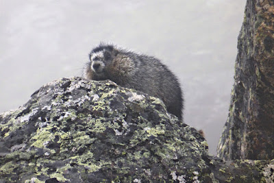
The beginning of the return was through mostly open terrain. We spotted a lazy marmot sunning off the trail.
As we passed, it turned to present only its rear end to us.
Joan and I continued hiking and re-entered the wooded section. The slope on either side of the path remained steep. Then, steady but unhurried, a mama grizzly and her yearling cub appeared on the path ahead. Coming towards us. Joan and I stepped off the path on the uphill side, and I pulled out my bear spray just in case. Mama came closer, glanced at us, and stepped off the path to the downhill side. She continued her rhythmic pace, but the youngster was curious. He looked at us. He took one step towards us. Joan wondered what mom would do if we had to spray her cub?
 
But mom had trained him well, and he joined her on the other side of the path. The duo passed behind some boulders across from us. The irrepressible youngster popped up again from behind the rocks, wishing he could check us out closer, but mom simply continued her stroll. Once well behind us, she crossed the path and began climbing up the slope, junior in tow. I holstered my bear spray.

Back at the lodge, we reported our adventure. "Oh," the guy at the desk said, "that's bear #142. She's well known around here." (In fact, she was spotted near Moraine Lake itself
the next day.) Moraine Lake has so many visitors, we realized, that any bear who prefers this high valley must be accustomed to humans. It's up to us to not panic and do something stupid.

Sunday, June 30, 2024

Hiking Canada 2023: Lake McArthur

Day 9
On July 19th, 2023, Joan and I agreed, "Let's get a good hike in, but also have a bit of a recovery day." To that end, we decided to visit Lake McArthur, taking the Big Larches trail (Route 2) for the first leg, hoping to see some pikas or marmots there.
First, we passed by the shores of Mary Lake.
The Big Larches trail climbs a stone-and-root staircase along the edge of a rubble field, the accumulation of material that's fallen off Mount Schaffer.
On this day, Joan and I didn't spot any pikas or marmots here. We reached Schaffer Lake and, bearing left, continued.
Out of curiosity, we visited the sign-up kiosk for the Odaray Grandview. The pass there is a wildlife corridor, and there are seasonal limits on the number of groups using the Odaray Highline trail. One group had already returned, and we chatted with them. The fourth and final group signed in ~10:30.
Joan and I returned to the McArthur Highline trail, and saw a marmot family -- yay! Here's a youngster:
And somebody's keeping an eye on him.
A little over half an hour later, we arrived at Lake McArthur, and found a spot to sit for lunch.
As we ate, we saw a family of ptarmigans foraging. Here's a better panorama of the scene. Today the air was clear.
Another group was down by the lakeshore. That water is cold, by the way. Glacier melt!
Photographers taking pictures of photographers.
In this panorama, we can see a trail at far right.
There's an intersection where a hiker can take the Low Level trail to return, rather than retracting their steps on the Highline, or go a short bit further around the lake.
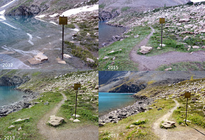
In a wet year, we've seen that sign with a couple of inches of water at its feet, and in a dry one, more shore exposed.
During our return, we spotted a pika either working diligently on its harvest, or on its lunch.
He paused for a moment.
The return from Lake McArthur first afforded us a view from above, rather than beside, Schaffer Lake.
At this point in the hike, there were too many critters to keep track of. Basking, playing marmots. Foraging pikas. One pika, not six feet away, issued a loud, high-pitched warning call when a bald eagle flew overhead. A mom golden-eye duck and her sole remaining chick sheltered on a rock in the middle of Schaffer.
From here, Joan and I took the trail down to the Elizabeth Parker hut. This route is boring at other times of the year, but today, it was full of flowers, ferns, butterflies, and moths. At the Le Relais camp store, we even bought O'Hara-themed T-shirts. Our hike today was less strenuous than yesterday's trek, but given the views and the wildlife, it was a winner.

Tuesday, October 27, 2020

Canada (2019) Part Four -- Views and Surprises

Sept. 12th began with cloudy skies. Today's goal was Lake McArthur, and having already done the Big Larches trail and its stone steps, we took the more utilitarian Schaeffer Lake trail via the Parker Hut.

The trail was enhanced by autumnal wildflowers.
A closeup of a paintbrush.

When we reached the meadow next to Schaeffer Lake we could see mountain goats over on Odaray mountain. This was an auspicious start! (Click on the image to enlarge.)

Out of curiosity we stopped at the sign-in kiosk for the Odaray Highline. From this point a trail to the left heads towards McArthur, and to the right a trail crosses the gap to the Highline. That section is restricted due to the pass's being a wildlife corridor, especially for bears. From August 15th to September 15th only two groups per day should cross to the Highline. Amazingly, although Joan and I aren't the swiftest hikers nobody had signed in yet, even though it was after 10:30. This was an opportunity not to miss. We waited to see if anyone else would show up, to form a single group for the crossing. No one did. We advanced as clouds and fog rolled into the pass.

There was a creature ahead, sitting atop a boulder.

That little bump on the right midway up.
We inched closer and I used my zoom to get a better look.

In fact, we spotted four marmots of the year. Not having seen any marmots this visit, and knowing that the odds of seeing one in September were lower, Joan and I were thrilled.

Not to be outdone, a pika showed up.

The Odaray Highline trail emerged from the rock piles and became a pleasant, gently rising stroll. The Lake O'Hara basin was often visible below; the mists had departed but it was overcast and breezy. Dress warmly.


The Highline ends at a bend in the mountain's profile. Long ago, in the 1970s, it continued on to the Odaray Prospect, but after a bear incident (they are fond of hunting goats there) the area became off-limits to hikers.

Here we adjusted our layers for a body-warming clamber up to the Grandview. The trail turned sharply left and began a steep climb, and soon we met three women coming down who hadn't signed into the kiosk. We later discovered that they'd signed in for the wrong day!

The path narrowed and clung to the face of the mountain, and during the final third a few places begged for my hands to grab something to ensure my equilibrium. But it was worth it. 

When we broke out onto the height there was a choice, to proceed left and continue a gentle scree-littered ascent, or straight ahead a short distance for another view. We went straight.

Linda Lake below center, O'Hara valley and access road far right.

After gawking here we continued up the slope to one of the favored spots for a stunning panorama in the other direction. Small cairns and a rock windscreen erected by previous hikers were scattered about.

Left to right: Lakes O'Hara, Schaeffer, and, up high, McArthur. Alpine routes visible in binos.

We drank it in and took photos, including the stratified glacier even higher up.

The wind was brutally cold up here on the flanks of the mountain, forcing us to reluctantly descend before having lunch. Just before reaching the Highline Joan and I happily sat on some rocks and munched.

We retraced the Highline and caught up with a group of five admiring a fearless young marmot; they had gone as far as the closed zone sign and then turned around. 

When Joan and I reached the pass we decided to continue past the sign-in kiosk and join the Lake McArthur route briefly for our return to Schaeffer Lake. The choice was a gift as we were treated to multiple pikas,

and a full-grown marmot.

I'm ready for my close-up.

 Today's wildlife was a highlight of this O'Hara visit.

Schaeffer Lake came into view.

Just beyond the shores of the lake the switchback descent to O'Hara would begin.

 Soon we were back at our cabin. After dinner we began the task of organizing all that had exploded out of our duffels over the last five days, for tomorrow afternoon we must say goodbye and take the bus 11 kilometers down to our car.

Wednesday, January 30, 2019

On the 15th Day of Hiking (Galatea Lakes)

The Galatea Lakes were one of our "goal" hikes this year. Joan and I had explored the lowest reaches of the trail last year, but that barely scratched the surface. We had a quick breakfast at the Market Café in the lodge and purchased sandwiches, cookies, and chocolate from Le Chocolatier for lunch and trail snacks.

The forecast called for showers by 3pm, but Mount Kidd glowed at the Galatea Trail parking area.
We're the only ones, shortly before 9:00
After a quick descent to the Kananaskis River the first and largest bridge of the journey appeared.
Soon there was another bridge, surrounded by the rubble from the 2013 flood.
On the far side, a trail map.
The sign says Lillian Lake, 5.5km / 3.4 miles, Galatea Lakes 6.6 km / 4.1 miles. Another source puts the Lillian Lake round trip at 14.3 km -- YMMV. The altitude gain estimates range up to 2850 feet (870 m) to Galatea so the distance feels greater.

The trail ascends the creek valley, sometimes with switchbacks, sometimes almost level. We passed at least one trailcam.
One of the many bridges in the first third of the trail. (The 2017 blog entry contains many more photos of this stretch.)
This image looks back to our origin, early in the hike. About this time the trail crossed a rocky avalanche path; there we were passed by four men, two young men that sounded Canadian and two older Asian men.
Periodically we stopped to take in the scale of the flood damage, immense even five years later.
As we continued to climb Joan and I passed above several slot canyons with narrow waterfalls. Steep, sketchy side trails led down to some of these and might have offered a better view, but we decided not to take the risk.

One oddity was plastic bags of dog poop abandoned by the side of the trail. Hey, if it's in a plastic bag, why not carry it out?

The bridges became more modest as we went up and up. Lingering snow appeared.
Smaller bridges for the narrowing stream.
What Joan saw:
Not going off-trail here!
Prior to the 2013 floods the Guinn's Pass trail departed from the Galatea Lake trail a couple of kilometers before Lillian Lake. It was a brutally steep climb, and prone to erosion. That route has now been moved, but I failed to photograph the closure sign for the old trail. In effect, the direct climb up was replaced with a huge switchback: proceed past Lillian Lake to not far from Galatea Lake, and there's the new Guinn's Pass trail.
We had seen Guinn's pass from Buller Pass two days ago.

Joan and I crossed a two-log, no-railing footbridge and reached Lillian Lake. We continued to the far side, next to the campground, where we sat on a bench and split half a chocolate bar.
The four hikers that had passed us earlier were a bit further along the shoreline, as seen above. We could hear one of them say, "So, Mr. Lee, do you have any children?" Aha. The two Canadian guys were acting as guides for visitors.

As Joan and I prepared to leave a loud buzzing noise burst the quiet, a sound of angry hornets. They were flying a drone! Which is illegal inside a national or provincial park without a permit, and we were suspicious that these men did not have one, but were taking advantage of a weekday in the off season.

We climbed through a series of switchbacks rising behind Lillian Lake until the trail emerged into a rocky zone,
Looking back at Lillian.
where it more or less went straight up. We followed a series of cairns through the scree, and discovered that the first bench wasn't the summit. We paused here to grab a quick lunch -- half a sandwich and a big cookie -- and pressed on.

It wasn't long before we reached the Guinn's Pass intersection.
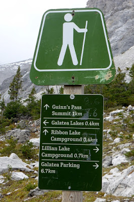
This sign is puzzling. It looks like it's been played with, and now makes no sense. Only 0.4km to the Ribbon Lake Campground? No way. Even as the crow flies it's a good 2.25 km to the campground! (Click on the image below to enlarge.)
And much further than that by trail!
Up here amidst the rocks we encountered two pikas. True to form, they made several warning eeep! calls.
Cute little critters, full of hustle.
Joan and I went a bit further to get a good look at Lower Galatea Lake.
The upper lake is beyond the rise at the far end.
There were clouds rising from the valley and occasional snow flurries. We decided there wasn't time, nor was it good weather, to press on to the upper lake. Soon after we began our return Joan took a photo of me, a rarity in this blog.
As we headed back down to Lillian the air warmed; the snow flurries intensified and mixed with drizzle.
At the lake we took advantage of a fabulous new biffy at the campground.
A solar powered composting toilet, with a triumphal arch, scalloped edges to the walkway, translucent roof, and best of all, separate ladies and gents rooms!
The pig and frog accompanying us on this hike went into our packs as we dressed for wet weather, which it was all the way down. Here's a photo of our hiking companions from earlier in the trip:
Dart, on the left, and Kristinn
Not so far below the lake we encountered fifteen young men and women headed to Lillian Lake to begin several days of back country camping. In the manner of youth they were carrying heavy loads, no two of which were the same, many with items exposed to the weather. They were full of enthusiasm but weary of the uphill slog, so we were happy to tell them "it's not far."

The rain intensified. Although downhill is faster than uphill, it seemed much longer. We passed two more backpackers headed to the lake. Then, at the end of one of the lower bridges, Ben slipped on the last step. His rain pants and pack cover were muddied, but no damage was done.

Back at the hotel we draped outerwear and accessories everywhere to dry; fortunately even in wet weather things indoors (and warm) dry rapidly.

Tomorrow, new road as well as new trail. What will the weather bring?