At breakfast Joan and I discovered a beneficial change to the morning routine at Mount Engadine Lodge. Since our first visit in 2004, the fixings for assemble-your-own lunches were brought out only after everybody finished breakfast and the breakfast fixings were cleared away. This meant that the lunches weren't ready as early as they might have been, and delayed the start of our hikes. Combined with the fact that for most hikes you'll need to drive to the trailhead, it made for a late start for long treks. In the new system, you fill out a lunch checklist at the start of breakfast, and the brown paper sack is ready to go when your breakfast is over. This change definitely rates a +1.
The afternoon weather forecast was uncertain, so Joan and I decided to postpone an attempt on Windtower until tomorrow, and hike today to the Sparrowhawk Tarns. (A tarn is a small mountain pool or lake.) This is a route we had tackled once before, several years ago, with mixed results. The middle section of the hike requires finding your way uphill over rock falls, and the guidebook we used had led us, either deliberately or through lack of clarity, into a series of exhausting clambers that weren't headed in quite the right direction. And we haven't been the only ones. This year we hoped, armed with better guidance, to reach the tarns.
The ascent starts through the woods. We quickly encountered preliminary work on the section of the Trans Canada Trail that will head south on the east side of the Spray Lakes.
We'll see more of this endeavor tomorrow.
There are fossils to be seen here if you keep your eyes open. Here's a coral, from when these mountains were sedimentary seabeds.
Nearby, a scattering of fragments.
As we ascended the woods continually thinned. In this photo, we're looking back towards the Spray Lakes.
A couple of minutes further on we passed this midden, cones and discards from squirrels, perhaps generations of squirrels.
And shortly thereafter we emerged from the woods and faced the extensive rockfalls. This photo captures the right-hand (southern) portion of the barrier, the direction we'll be heading. Notice the cairn at center bottom. The latter part of the trail could use more of these.
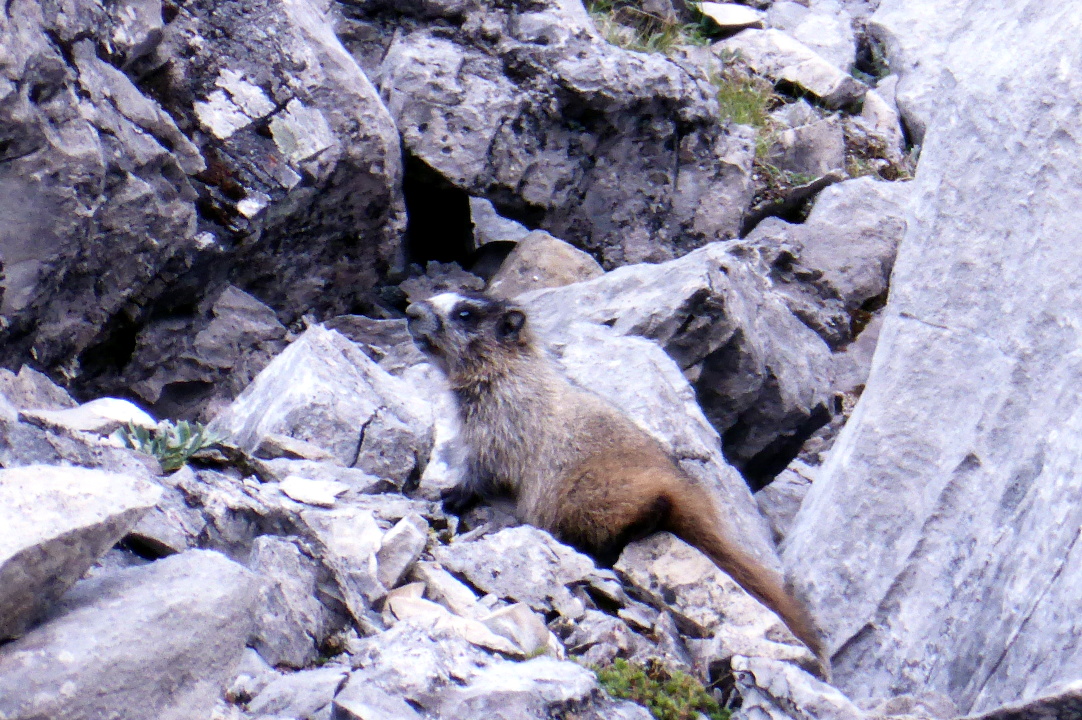
The trail leads us towards the southern side of the valley, and this young marmot.
Then we head up the valley. Immediately the trail divides, as hikers have beaten different routes through the boulders. Some routes have been marked as "no go" by other hikers placing dead branches or logs across the path. So far, however, the route finding is not difficult. We encountered a pika.
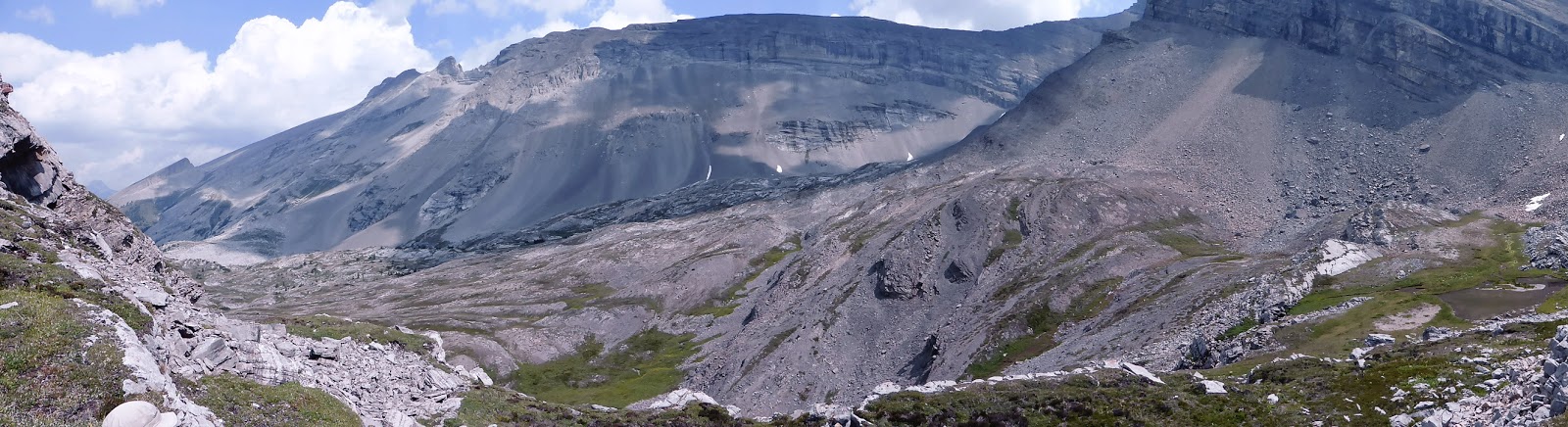
After the first 45 minutes of working through the rocks, we paused again looked back to the Spray Lakes.
The view directly up the valley is impressive, but that's not where we're going. The one tarn in this image is as far as Joan and I reached a decade ago, and it's not the main show.
Frequently consulting our guidebook, we veer to the right. After another 45 minutes, when we look back, the Spray Lakes are out of sight.
Next we must climb a series of short rock faces. It's lunchtime after the first rock face or two (it's easy to lose count!), and I'm running out of steam. When I find myself thinking, or even saying to Joan, "I don't care to go any further," that means I need a sit-down and a snack. We proceed to lunch on a bench above small tarn. It's August 4th, and by now there is no more snow melt feeding the tarns, which are shrinking.
One of our turkey lunches had no turkey in it, but we managed. A marmot kept an eye on us during our breather.
At one point we saw a swift bird zooming along the valley faces, perhaps a peregrine falcon.
With my blood sugar restored, I realized it was a modest stroll to the far tarns. Here Joan has gone out ahead.
Sometimes the tarns at the foot of the valley wall are full of sparkling blue water, sometimes not.
From where I stood taking the above photo, now looking the other way I snapped a photo of Joan inspecting the view.
Time to return. After descending most of the rock faces just climbed, we reach a small green meadow, and a stream.
Joan and I enter the glen, following a faint trail. In this sheltered location wildflowers are still blooming.
We work our way through the maze of stones, sometimes along the same trail we climbed, sometimes not. Eventually the Spray Lakes come into view again. It's getting cloudier ahead.
We continue our return, and spot another pika.
Near the end of the rockfall zone we admired this encrustation of fossilized corals.
Finally we're near the end. The wind has picked up, pushing whitecaps on the lake.
Joan and I arrived back at the lodge just before a band of rain showers passed through. After the rain, the view across the meadow beckoned to my camera.
The mud wallow just below the lodge called in a male moose. In the evenings and twilight there is almost always somebody visiting the mud. This gentlemoose showed up well in advance of darkness.
Then it was time for bed. Tomorrow is our Windtower day, if we are to have one at all this year.
Today was a transit day; Joan and I are flying out of Mistaya Lodge and driving to Mount Engadine Lodge. Our pigs, Knuckles and Pierre, were ready to go first thing in the morning. They like helicopter rides.
It promised to be another sunny day.
There's a hummingbird feeder on the south side of the lodge that is much less fought over than the east side feeder.
After carrying departing guests' gear out to the helipad, David and Sandra struck a well-practiced pose for the camera.
Our chariot arrives.
Joan and I, on the first group out, will be dropped off at a back-country landing point, and then driven the rest of the way back to Golden. The chopper will also drop off garbage and pick up supplies and incoming guests at the landing point. Only the last group in the changeover will fly all the way to Golden.
The latter half of the flight follows a valley with a braided glacial river.
Today I had the privilege of sitting in the jump seat, up front next to the pilot. Here's what the instrument panel looks like.
This video clip covers the first 90 seconds of our flight, and the last 90 seconds.
As you can see, the whirlybird kicks up a lot of dust. As a confirmed eyeglasses wearer and a camera-pointer, I hate dust, especially gritty outdoor chaff. While the others huddled behind an SUV while the heli took off, I hightailed it across the road.
The Mistaya Lodge folks drove us back to the heliport in Golden, where we retrieved our rental car. The remainder of the day would be spent driving to Mount Engadine Lodge. We could pick up some new road, and road we hadn't driven on in several years, by driving down to Radium and then back up Highway 93. It would be longer, but also avoids a chunk of driving on the Trans-Canada at the end of a holiday weekend.
The drive down to Radium had little traffic. The sharp northward jog on Highway 93 after leaving Radium hosts a viewpoint that looks up and down the Kootenay Valley. The haze in this photo was generated mostly by forest fires elsewhere.
While at this overlook we saw bicycle riders obviously participating in some event; there were support vehicles parked across the road from the viewpoint, they had numbers on their jerseys, and so forth. We chatted with one of the organizers, a guy originally from Chicago, and discovered that this ride was one of the ongoing activities of Sea-to-Sea, an anti-poverty organization.
On arriving at Mount Engadine Lodge we were told that the Moose suite, our favorite, was not available, even though we had reserved it nine months before. As we unpacked in the Elk suite, Joan and I discovered that two light bulbs were burned out. They were quickly replaced by the staff, but we knew the Lodge had changed ownership and management since last year, and this was not an auspicious start. That night's dinner was still excellent, however, and the major question seemed to be tomorrow's weather.
I put my camera into burst mode and tried to get some hummingbird pictures before we left on today's hike. The feeder on the east side of the lodge is visited by swarms of rufous hummingbirds, who will buzz each other and contest each other's presence at the feeder. We were told that when the birds are very young, they tolerate each other well, because they are typically raised more than one to a nest. Then suddenly they are territorial and there are waves of frantic, buzzing "dogfights" followed by brief truces at the feeder.
Another photo.
It was another handsome day, making four in a row since we left Lake O'Hara. Today most of the lodge guests are taking the guided Three Lakes Hike, vigorous but not as strenuous as yesterday's climb of West Peyto Peak. This map shows the key locations of this wide loop (click to enlarge).
We started climbing straightaway after leaving the lodge.
Our first major stop, not visible in the above map, is the Karst Hole, where the water leaving Stonebird Lake (bottom right corner of the map) disappears into the porous terrain.
It was a good spot to stop and switch from huff-and-puff to a moment of contemplation. Stonebird Lake is beyond the near horizon.
Over the rocks and up a draw we hiked.
Stonebird Lake hove into view below the peaks that define the continental divide and the boundary between Alberta and British Columbia.
We continued around the lake to the left; in the grassy slopes fireweed was blooming.
We climbed further, past the lake,
and here Sandra, our guide, pointed out the namesake bird image in the cliff face. It took me a few moments, but I finally spotted it. The degree of difficulty recognizing it varies with the lighting and the amount of water cascading down the cliff. This photo zooms in on the rocky avian, smack in the center and filling most of the space from top to bottom.
We quickly came up to Longshadow Lake, and decided it was a good place for first lunch.
The next photo looks back as we left the lake, post-dining.
Twenty minutes later we encountered young hoary marmot, full of curiosity about us.
We continued up to the top of the "Mista-Vista" knob, 8,300 ft. altitude, and stared at the panorama.
I walked over to the southern edge, and spotted the third of our three lakes, Leprechaun Lake, below. This lake has no visible outflow.
Our group came down from Mista Vista and walked along Heather Ridge, where we stopped for a snack, or, if you budgeted your food carefully, your second lunch. We learned from Sandra that fir trees have cones that point up, while spruce bear cones that point down. ("Fir fingers; spruce sag.") Descending from the ridge we entered the woods again, and saw some flowers that had recently boomed, including butterwort.
We arrived back at the lodge and settled our pigs back in the window.
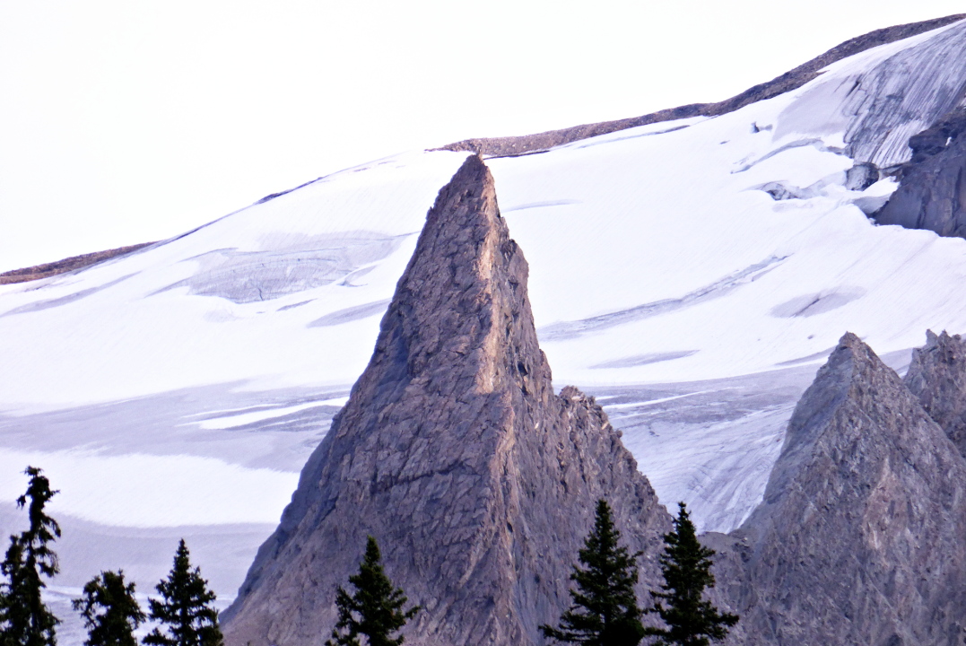
Dinner was early tonight, to give everybody time to pack for tomorrow's departure. Afterwards, Joan and I visited the helipad to check out the evening sun,
and one of the best images was looking south towards the Sceptre Spire.
Joan and I also took a few minutes to visit the greenhouse close by the lodge. Much of the lettuce, spinach, and other greens used by the lodge come from the greenhouse.
Then it was time to turn in, our last night at Mistaya Lodge.