
The forecast called for showers by 3pm, but Mount Kidd glowed at the Galatea Trail parking area.
 |
| We're the only ones, shortly before 9:00 |

Soon there was another bridge, surrounded by the rubble from the 2013 flood.

On the far side, a trail map.

The sign says Lillian Lake, 5.5km / 3.4 miles, Galatea Lakes 6.6 km / 4.1 miles. Another source puts the Lillian Lake round trip at 14.3 km -- YMMV. The altitude gain estimates range up to 2850 feet (870 m) to Galatea so the distance feels greater.
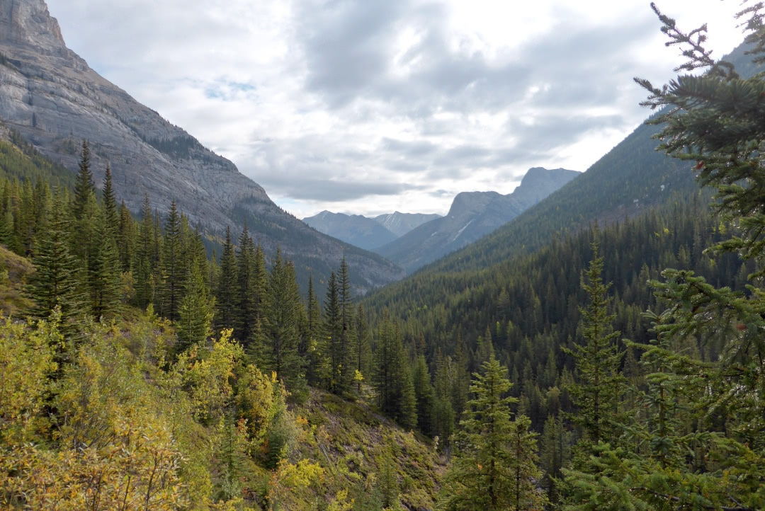
The trail ascends the creek valley, sometimes with switchbacks, sometimes almost level. We passed at least one trailcam.
 One of the many bridges in the first third of the trail. (The 2017 blog entry contains many more photos of this stretch.)
 This image looks back to our origin, early in the hike. About this time the trail crossed a rocky avalanche path; there we were passed by four men, two young men that sounded Canadian and two older Asian men.
 Periodically we stopped to take in the scale of the flood damage, immense even five years later.
 As we continued to climb Joan and I passed above several slot canyons with narrow waterfalls. Steep, sketchy side trails led down to some of these and might have offered a better view, but we decided not to take the risk.
One oddity was plastic bags of dog poop abandoned by the side of the trail. Hey, if it's in a plastic bag, why not carry it out?
The bridges became more modest as we went up and up. Lingering snow appeared.
 Smaller bridges for the narrowing stream.
 What Joan saw:
Prior to the 2013 floods the Guinn's Pass trail departed from the Galatea Lake trail a couple of kilometers before Lillian Lake. It was a brutally steep climb, and prone to erosion. That route has now been moved, but I failed to photograph the closure sign for the old trail. In effect, the direct climb up was replaced with a huge switchback: proceed past Lillian Lake to not far from Galatea Lake, and there's the new Guinn's Pass trail.
The trail ascends the creek valley, sometimes with switchbacks, sometimes almost level. We passed at least one trailcam.


One oddity was plastic bags of dog poop abandoned by the side of the trail. Hey, if it's in a plastic bag, why not carry it out?
The bridges became more modest as we went up and up. Lingering snow appeared.


 |
| Not going off-trail here! |

We had seen Guinn's pass from Buller Pass two days ago.
Joan and I crossed a two-log, no-railing footbridge and reached Lillian Lake. We continued to the far side, next to the campground, where we sat on a bench and split half a chocolate bar.
 The four hikers that had passed us earlier were a bit further along the shoreline, as seen above. We could hear one of them say, "So, Mr. Lee, do you have any children?" Aha. The two Canadian guys were acting as guides for visitors.
As Joan and I prepared to leave a loud buzzing noise burst the quiet, a sound of angry hornets. They were flying a drone! Which is illegal inside a national or provincial park without a permit, and we were suspicious that these men did not have one, but were taking advantage of a weekday in the off season.
We climbed through a series of switchbacks rising behind Lillian Lake until the trail emerged into a rocky zone,
where it more or less went straight up. We followed a series of cairns through the scree, and discovered that the first bench wasn't the summit. We paused here to grab a quick lunch -- half a sandwich and a big cookie -- and pressed on.
It wasn't long before we reached the Guinn's Pass intersection.
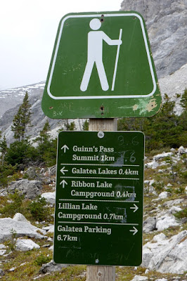 This sign is puzzling. It looks like it's been played with, and now makes no sense. Only 0.4km to the Ribbon Lake Campground? No way. Even as the crow flies it's a good 2.25 km to the campground! (Click on the image below to enlarge.)
Up here amidst the rocks we encountered two pikas. True to form, they made several warning eeep! calls.
Joan and I went a bit further to get a good look at Lower Galatea Lake.
There were clouds rising from the valley and occasional snow flurries. We decided there wasn't time, nor was it good weather, to press on to the upper lake. Soon after we began our return Joan took a photo of me, a rarity in this blog.
 As we headed back down to Lillian the air warmed; the snow flurries intensified and mixed with drizzle.
 At the lake we took advantage of a fabulous new biffy at the campground.
 A solar powered composting toilet, with a triumphal arch, scalloped edges to the walkway, translucent roof, and best of all, separate ladies and gents rooms!
 The pig and frog accompanying us on this hike went into our packs as we dressed for wet weather, which it was all the way down. Here's a photo of our hiking companions from earlier in the trip:
Not so far below the lake we encountered fifteen young men and women headed to Lillian Lake to begin several days of back country camping. In the manner of youth they were carrying heavy loads, no two of which were the same, many with items exposed to the weather. They were full of enthusiasm but weary of the uphill slog, so we were happy to tell them "it's not far."
The rain intensified. Although downhill is faster than uphill, it seemed much longer. We passed two more backpackers headed to the lake. Then, at the end of one of the lower bridges, Ben slipped on the last step. His rain pants and pack cover were muddied, but no damage was done.
Back at the hotel we draped outerwear and accessories everywhere to dry; fortunately even in wet weather things indoors (and warm) dry rapidly.
Tomorrow, new road as well as new trail. What will the weather bring?
Joan and I crossed a two-log, no-railing footbridge and reached Lillian Lake. We continued to the far side, next to the campground, where we sat on a bench and split half a chocolate bar.

As Joan and I prepared to leave a loud buzzing noise burst the quiet, a sound of angry hornets. They were flying a drone! Which is illegal inside a national or provincial park without a permit, and we were suspicious that these men did not have one, but were taking advantage of a weekday in the off season.
We climbed through a series of switchbacks rising behind Lillian Lake until the trail emerged into a rocky zone,
 |
| Looking back at Lillian. |
It wasn't long before we reached the Guinn's Pass intersection.

 |
| And much further than that by trail! |
 |
| Cute little critters, full of hustle. |
 |
| The upper lake is beyond the rise at the far end. |


 |
| Dart, on the left, and Kristinn |
The rain intensified. Although downhill is faster than uphill, it seemed much longer. We passed two more backpackers headed to the lake. Then, at the end of one of the lower bridges, Ben slipped on the last step. His rain pants and pack cover were muddied, but no damage was done.
Back at the hotel we draped outerwear and accessories everywhere to dry; fortunately even in wet weather things indoors (and warm) dry rapidly.
Tomorrow, new road as well as new trail. What will the weather bring?


