Wednesday, July 25, 2018

Metro 5-0: Witches Hollow

Thursday, May 12th, was sunny with the promise/threat of reaching the mid-80s. Joan and I drove down to Clear Creek Metro Park to participate in a "Metro 5-0" hike, a guided five-mile off-trail tramp for those over 50. Today our goal was Witches Hollow, a route and destination through areas of the preserve normally off-limits to the public.

We arrived neither first nor last; the parking area as shown here would end up hosting twice as many cars.

Our group included two Metro Parks employees and three volunteers, sufficient to prevent any losses to the herd as we strung out along the route. After an initial flat section we passed the last chance to turn back and began to climb.
Our first major stop for water and regrouping was at "the gorge." This feature looked familiar; Joan and I had visited it on another Metro 5-0 hike in some earlier year.
Marty, the manager of Clear Creek Metro Park, was one of our guides. He revealed that they'd recently gotten lost doing a "pre-hike" for this event, which amused everybody. But things seemed to be under control as we worked our way through underbrush, briars, and more open areas, navigating from blue tape to blue tape dangling from the vegetation. We noticed both spotted wintergreen and rattlesnake plantain and learned to distinguish between the two.

Several water and regrouping stops later we dropped into the upper reaches of a stream.
It soon became necessary for our guides, official volunteers, and unofficial path-finders to scout several crossings of this creek, necessitated by numerous fallen trees and, in spots, thick brush. Well, it was advertised as a rugged, off-trail hike!

We were rewarded in the downstream locations where the deepening hollow opened up, revealing sandstone formations.

We could explore the sides of the valley,
and poke around a bit,
as long as we came together for the next leg.
The name "Witches Hollow" might come from folks visiting it in the 1970s, before the park existed, for magical purposes. However, lingering evidence including empty bottles and an abandoned boom-box/radio/tape deck (I didn't get a good look at it) indicated that this could just as well have been a hidden party spot. Our guides carried the trash out.

With a mile to go it was time to cross Clear Creek itself. (Our route was a loop, not an out-and-back.) A rope was strung diagonally across the watercourse to a landing spot while Joan and I swapped our hiking boots for Tevas. The current wasn't an obstacle, although it varied from ankle- to knee-deep, and the cold water felt wonderful. On the far side we wiped our feet and put the boots back on.

For the last mile there was an option to ride in a ranger truck, but Joan and I hoofed it back to the parking area. You can see that there are impressive sandstone formations to be seen at Clear Creek even if you're not in the mood for a five-mile ramble.
Witches Hollow was an adventurous hike, but well worth the effort.

Monday, July 16, 2018

HIghlands and Islands: To Lewis and Harris

The last day of May saw our Natural Habitat Adventures group travel by van, ferry, and van again as we journeyed from Lochinver, our most recent base, to the island of Lewis and Harris, part of the Outer Hebrides.

The first leg of our road journey took us past Loch Assynt and the nearby Little Assynt.
It was atmospheric starting out.
The route looks like a large question-mark, because Jim avoided the single-track roads.
In Ullapool we had time to wander before the ferry departed. Several of us stopped in a bookstore for some fun browsing, and Joan picked up Scottish Wild Flowers (Michael Scott), Women of the Highlands (Katherine Stewart), and some cards.

Then Joan and I wandered along the breakwater, and encountered an enthusiastic, aquatic, ball-fetching labrador retriever and his man. This photo marks our turnaround point.
The ferry was in view the whole time, docked.
Our group assembled in front of the ferry office at the appointed time and boarded. Standing several decks higher than the water, we could appreciate the heights behind Ullapool.
As the ferry cleared the dock the entirety of the town was in view.
It was a sunny day with a chilly sea breeze, so Joan and I started the ride from the back deck.
The warmest seats were in the center, not port/starboard.
Below and behind the back deck was the vehicle level, with plenty of trucks on this voyage. I hadn't realize Scotland has trouble with baguette thieves.
We had a good time chatting in the sunshine until Jonathan offered an indoor snack, which included millionaire's shortbread.

As we approached Stornoway, the capital and main settlement of Lewis and Harris, Joan and I kept an eye out for the Beasts of Holm, the rocks upon which the overloaded HMY Iolaire foundered at 2:30am New Year's Day, 1919, one of the worst 20th Century British maritime disasters. When I Heard the Bell (John Macleod) is a detailed account of the wreck, what came before, and what came after. We had both read the book and found it engrossing.

Our Caledonian MacBrayne passed them by and safely pulled into Stornoway harbor.
Another ship was already there.
A block or two from the dockside we had a lunch at the Digby Chick, followed by a visit to the memorial to the Iolaire.
Now we resumed transport by van, driven by the ultra-capable Jim, and visited the historic Arnol Blackhouse. A traditional blackhouse was built with double dry-stone walls packed with earth and a thatched roof secured against Atlantic gales by stone-weighted ropes. The village of Arnol is known for its many ruined blackhouses, and the museum is adjacent to the restored #42.
Peat was the only available fuel, laboriously cut from boggy land and stacked to dry before burning. It's essentially compressed vegetation that's too young -- way too young -- to have been transformed into coal.
We stooped to enter the blackhouse; entrances were kept to a minimum size and number to keep the inside warmth inside. This sign includes a diagram of the layout (click on the image to enlarge).
This is the livestock section, a source of body heat to supplement the peat.
A smoky discourse from Jonathan.
This is handwoven rope. Whatever could be made locally was made locally.
The hearth was the center of the home. There was no chimney; the peat smoke escaped, mostly, through the blackened thatch. It was important to never, ever let the fire go out.
Sleeping quarters.
Nearby was a "new house," built by those who could afford it during the late 19th and early 20th centuries. It was drafty and cold compared to the double-walled and virtually windowless blackhouse, but it was modern.
An interior photo.
From Arnol our group then drove to the Standing Stones of Callanish, an archaeological site dating from the late Neolithic and Bronze Ages -- from 5,000 years ago. This is a popular spot for visitors, including cycling groups.
The arrangement of the stones includes a double row, or alley, three lines, and a central circle:
By Henry James derivative work: Pasicles [Public domain], via Wikimedia Commons.

The stones had been half-submerged in peat over the millennia, but in the mid-18th Century 1.5 meters (5 feet) of that peat was removed to restore the ground to its original appearance.

Looking down the long alley.
The central stones.
Louise was taking it all in.
A more modern phenomenon -- Callanish selfies.
The young girls on the edge of the photo asked Jonathan what they must do in order to "feel the magic of the stones." Jonathan replied that they needed to come at night and sit still for ten minutes; one answered immediately that they couldn't possibly sit still that long.

With the proper light, however, some daytime magic can be spotted.
From Callanish, which sits atop a small rise, other standing stone formations can be seen, including Callanish II and III. Binoculars are useful.

Callanish was our last big stop for the day, followed by a scenic drive down the spine of Lewis and Harris to the village of Tarbert, our home for the next two nights.
We checked into the Hotel Hebrides, and Joan and I immediately opened our windows; fortunately, our top-story room was not visited by the midges. After disassembling the obligatory duvet we were set for a comfortable night.

Tomorrow we would embark on a salt-water expedition. 

Thursday, July 5, 2018

Highlands and Islands: Isle of Handa

The next day, Wednesday May 30, Jim steered our NatHab van towards the town of Tarbet to spend the day at Handa Island, a wildlife reserve. At a brief rest stop I noticed this electric vehicle charger, seemingly out of place in the Scottish backcountry.
But then, the Scottish government is committed to renewable energy, largely wind power.

The roads grew narrower and narrower as we drew further away from Lochinver. Finally we were on a single-track path with frequent pullouts, called "passing places," and Jim maneuvered amongst them with great skill. Parking at the seasonal ferry was another challenge met. This photo shows the ferry dock, and Handa is the wide island in the background. The tide had left much of the jetty underwater.
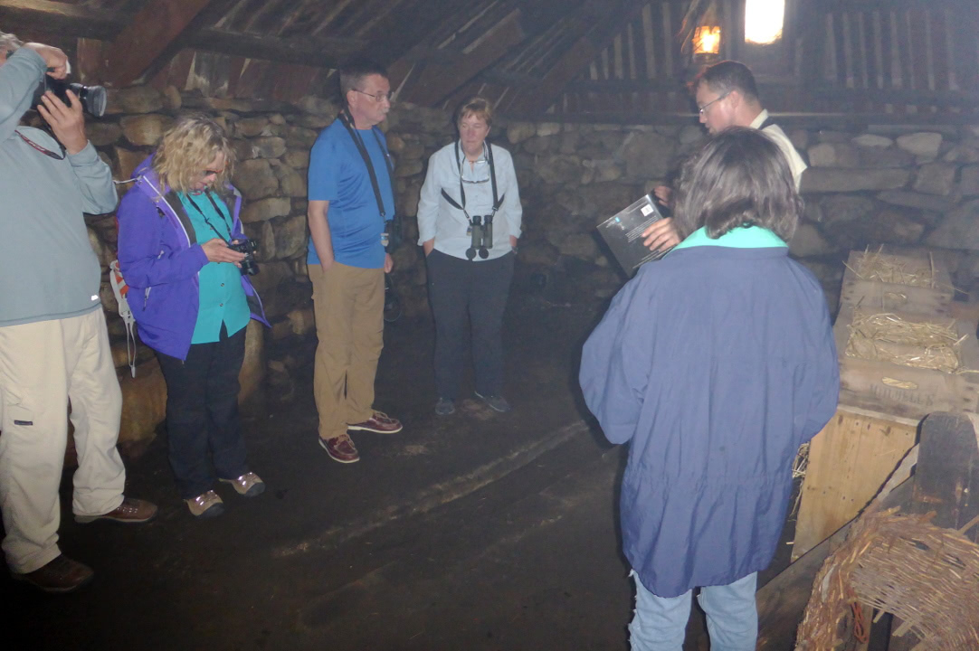
Our vessel was a semi-inflatable craft with room for twelve to fourteen people, comfortable enough for the short ride over. We climbed up the sandy dunes at the beach and arrived at the wardens and volunteers hut, and received an orientation briefing about what to do and not do. (You can also buy plush puffins and other knickknacks.)
Handa is owned by the Scourie Estate, primarily meaning Dr. Jean Balfour, but administered by the Scottish Wildlife Trust.

We set out in a counter-clockwise direction towards The Stacks on the north side.
We quickly came across a great skua, colloquially known as a bonxie, and then another and another.
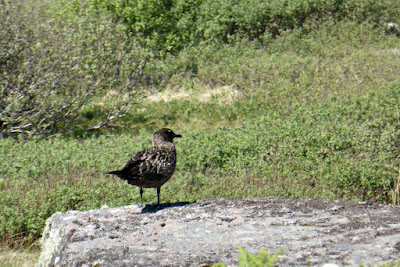
They also flew by often.
There was no shortage of orchids on this stretch of trail. This one is Heath spotted-orchid, likely subspecies ericetorum, which prefers acidic soils, such as peat.
We also spotted blooming butterwort, a "carnivorous" plant that uses sticky leaves to trap and digest insects as a supplement to its diet in poor soils. Some types prefer alkaline, others acidic soils.
Our group soon approached the ruins of crofters' houses.
Life on Handa was hard enough, but when the potato blight hit in the mid-18th Century, all the inhabitants emigrated to Canada. Here's a closer look at the stonework.
Of stones they had plenty. Soil not so much.
Handa also served as a cemetery for the surrounding area. Being on an island, the graves could not be disturbed by the wolves on the mainland.

We reached the rugged northern side of the island with its sea stacks, rock formations formed by the assaults of the North Atlantic.
Jonathan warned us not to creep too close to the edge.
Looking back the way we had come so far.
Any crevice or hollow in the cliffs was an opportunity for nesting seabirds.
A closeup.
On these cliffs the birds are safe from most predators, but the wardens and volunteers are monitoring a small rat population closely. According to this newsletter (a pdf), brown rats were extirpated from Handa in 1997 but fifteen years later they were back.

We staked out a lovely site for lunch and birdwatching.
We were all eager to see some of the charismatic puffins. It would be a pity to come to this island without binoculars.
They prefer burrows in the ground. Here's a
closeup, such as my camera could produce. Candace Andrews has pro level images here.
Even on a calm day the swells continued to batter away at the island.
As we continued counterclockwise we met Martin, a volunteer making stone steps on the heavily traveled trail, and marveled at his dedication and hard work.

A double rent in the island.

We lost what little altitude we'd gained as we approached the south side of the island, where various beaches lay.
Once back at the warden's hut there was time to explore the beaches, because other groups were ahead of us waiting for the ferry that constantly shuttled back and forth.
Our group returned in good cheer to the mainland, having enjoyed what Jonathan called the warmest and calmest day he'd ever experienced at Handa. The tide had fallen and left us a walk up the jetty. Jim pulled more drinks and biscuits/cookies out of our van, freshening us up for the return single-track ride.

We had a mandatory photo stop for Highland cows. These cattle are endowed with a double layer of hair, helping them survive the Scottish winter and giving them a unique appearance. One of our number, Nadia, is a big fan of the "highland coo," as it's pronounced, and this was an opportunity we couldn't pass up. Click on the image to enlarge.
Nice horns.
This was the landscape in which our coo was spotted. The fences demarcating the fields are made of stone.
If good fences make good neighbors, these should be great!
Then we were back at the Inver Lodge for dinner, and preparing to move on tomorrow to the Hebridean island of Lewis and Harris.