Thursday, November 29, 2018

On the 6th Day of Hiking (Opabin Plateau, Yukness Ledges)

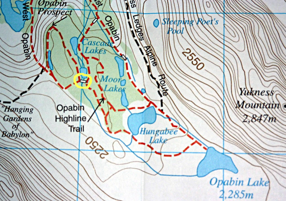
Who knows what the weather will bring? Sept. 11th started out OK if cloudy, with rare spots of blue. Joan and I finally shoved off at 10:00 and headed for the West Opabin Trail, much more interesting than the East trail. There were a couple of intersections before options other than West Opabin were left behind.
Looking back at the last intersection.
Interesting September foliage.
At first the trail was wide and low, passing Mary Lake, and then began to gently climb.
The route emerged from the forest and started scaling the edge of Opabin.
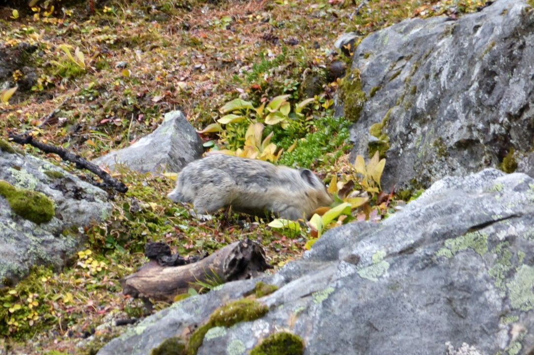
The view opened up immediately, an advantage the West Opabin trail holds over the East. We saw at least one pika on this climb, and heard others.
Looking back at Mary Lake.
Flagstones led the way after the trail crested, a short distance beyond the All Souls and Opabin Prospect intersections.
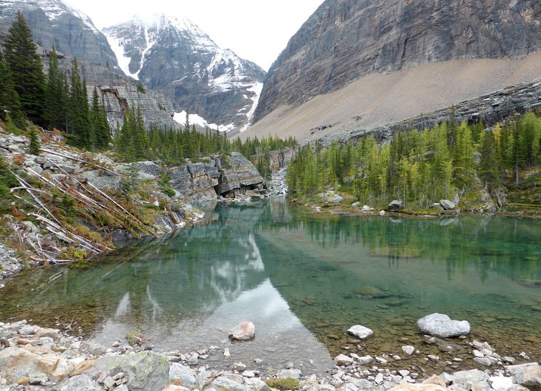
Following this trail, we reached the bridge at the head of the Cascade Lakes.
The view looking further south.
Ducks landed in the lakes and began diving and bobbing for food.
Through our binoculars we could see that hikers had reached All Souls Prospect.
Joan and I crossed the bridge and headed north, to catch the start of the Opabin Highline trail. Up on the Highline we had a close pika sighting.
The larches were yellower than down below.
We followed the trail past Hungabee Lake to the East Opabin trail,
not far from its junction with the Yukness Ledges route.

So far we had only one glimpse of anybody else! But three hikers were waiting at the Yukness Ledges intersection for something or somebody. Joan and I went up and up through the boulder field initiating Yukness, happy to traverse it headed up rather than down, and at the start of the ledges for a change. We paused at the foot of the less than unofficial route to Sleeping Poets Pool, but deferred to uncertain weather and left that for another visit. The view down to the Opabin Plateau was gratifying.
We sat on a suitable rock and ate lunch; now we were starting to meet hikers headed in the opposite direction. Lake O'Hara came into view as the trail bent around the slopes of Yukness mountain.
More hikers, including a Parks Canada ranger, came along headed the other way. Joan was excellent in dispensing advice and enthusiasm for O'Hara to those on the ledges for the first time.
She also spotted some intriguing seams and inclusions on one rock face.
Vigilance pays off. As the Huber Ledges came into view,
Joan spotted a mountain goat in the distance, our first of the visit. It settled down for a rest.
We reached the Victoria Lake cutoff and decided to keep going to Lake Oesa. Some of the hikers we now encountered seemed ill-equipped for the stony trail, wearing running shoes and such; at least, that was our opinion. Two guys posed us a difficult question: whether the Yukness Ledges are best described as carefully-picking-you-way, or a more even, if narrow, trail. The correct answer is "both!" We did tell them about the cutoff in case they decided early on that the ledges were not to their liking.

We stopped at Lake Oesa, but only to put on rain gear because weather was blowing in with disappearing views. Fortunately it never grew bad; a few ice pellets and some rain, just enough to force me to alternate keeping the hood of my rain jacket up versus down. We marveled at the turquoise color of Lake Lefroy under these conditions.

On reaching the O'Hara lakeshore Joan and I experienced a keyhole in the clouds that that sequentially allowed the sun to illuminate the Opabin bluffs,
Mount Yukness,
the Seven Veils waterfall at the far end of O'Hara,
and a stretch of cabins.

Today there was no bat in the cabin waiting for us. After another superb dinner at the lodge, Joan and I began mapping out alternatives for tomorrow, depending on the weather. We knew we could not predict it in advance.

Tuesday, November 20, 2018

On the 5th Day of Hiking (Lake McArthur)

The weather looked uncertain from the get-go on Sept. 10th, leading Joan and me to start out wearing our rainpants, as they are awkward to don at the last minute. They also provide a windbreaking layer over thin hiking pants.

We headed for Lake McArthur via the Big Larches trail, postponing any attempt at higher destinations such as Wiwaxy Gap or All Souls Prospect for better weather. The Big Larches trail soon climbed steeply along the flank of a boulder slope that cascades down from Mt. Schaffer.
In July this rock field is a likely place to spot hoary marmots and pikas; however, in September, most marmots have begun hibernating. The weather today may have also been a factor. Nonetheless we did see a couple of pikas busy with their foraging, adding tasty vegetation to their winter stores. In this photo, the pika's head is blurred because he/she is busy yanking out the goodies.
Pikas are workaholics, and for good reason.
The trail then passed into the woods for which the trail is named. The core of one old stump provided shelter to growing mosses.
The Big Larches trail took us to Schaffer Lake and then to the McArthur Pass trail. Along the way we saw some fresh scat that looked very bear-like, and we began calling out "Yo Bear!" every few minutes as long as we were in the woods.

On arriving at Schaffer Lake we saw clouds billowing up into valley from the far side, and the air became misty wet with light showers alternating with times of cessation. Not at all like last September! We took the High Level trail to McArthur, walking through clouds. Then we reached the cairn marking our arrival in the valley of the lake.
Joan and I found a good spot on a rocky promontory to sit and eat our packed lunches, which always include three fabulous O'Hara cookies. We could see the lake but not the peaks surrounding it. Sometimes the far end of the lake was clouded in; the scene's mood changed often with the variable light.
Occasionally we could see the glacier at the far end. This photo was taken from the edge of the water.
We finished lunch in a persistent light rain, and decided to return expeditiously by the Low Level trail followed by our less-favored route, the Alpine Meadow to the Elizabeth Parker hut. On the Low Level trail, before it dove into McArthur Pass, we saw four ptarmigans. Their plumage was beginning to turn white in preparation for winter. With the drizzle and fog, I didn't take any photos. Well, there was this one.
No ptarmigans in this picture.
The rain now changed into a rain/snow mix, but favoring rain. We marched back to the cabin, and closer to O'Hara, the decrease in altitude converted the remaining snowflakes to rain, which slacked off by the lakeshore.
The snow is sticking not far up.
Joan and I were shocked to find it was now only 2:30!

It was time to find places to hang things to dry. There are never enough hooks to hang stuff after hours in the wet, at any place we've been. We must be messy.

After much draping of gear Joan noticed something on the smoke detector over the door to the bathroom. Binoculars confirmed that it was a brown bat.
Warm, cozy, and dozing.
Joan went to the lodge to summon help, and two staff guys soon arrived. Their contraption to hold the bat -- a cloth sack without a handle but a square opening -- couldn't be deployed against a vertical surface near the peak of the ceiling. They used a few folds of sack material as insulation while plucking the bat by hand off the smoke alarm. This all appeared to be business as usual; we were told there's a group of bats nesting in the eaves of the cabin housing the two lodge chefs. Still, we were relieved that we'd spotted the bat before retiring for the night!

Fingers crossed for tomorrow's weather. While we've been told that September is the best month for weather in the Canadian Rockies, that's an average. September, over the years, has been the wettest, driest, coldest, and hottest month we've experienced.

Thursday, November 15, 2018

On the 4th Day of HIking (Lake Oesa)

Our fourth day of hiking in the Canadian Rockies began with a quick breakfast at Cathedral Mountain Lodge. As we ate, morning drizzles came and went, leading us to dither over what to pack and what to wear. After a drive back up Kicking Horse Pass to the parking area for Lake O'Hara, we waited with others at the shelter for the morning lodge bus.
Also waiting there was a couple we had met last September at O'Hara, Jeanette and Brian (spellings are approximate!). A parks ranger was greeting visitors and explaining the O'Hara system to walk-ins (11 km on the fire road). She told us that there were fewer walk-ins than the previous year, the year of free parks passes celebrating Canada's 150th year.

At the lodge we received trail lunches and our cabin assignment, #1, which would be available after 1:00; Joan and I planned to be on the trail well past that. We headed for Lake Oesa, but a few yards out we encountered a shower and returned the lodge porch to don rain paints and otherwise prepare for precipitation. By the time we'd done that the shower was over!

Soon we could look across O'Hara at the cabins; our #1 is the leftmost in this photo.
After several switchbacks we arrived at "lunch rock," as we call it, the top of a bluff overlooking the lake.
On the way we saw evidence of a rough winter, with avalanche tracks of downed or bent timber. Several trees had been turned into mere stubs at lunch rock.

As we hiked on Joan and I heard distant pikas and small birds, but no marmots. A faster, younger couple passed us, who held reservations for Abbot Hut tonight, now cancelled due to the closure of the hut for foundation repairs. Parks Canada does not want it to slide off the side of the mountain.

Our path wound through a couple of boulder fields before reaching the bottom of the Grassi Steps,
named for their builder, the coal miner and one-man trail crew, Lawrence Grassi. This plaque is at the top of the stairs:
I think of this waterfall as the "curve." Here the trail,
after climbing steeply, takes a sharp bend and levels out. Immediately after is Victoria Lake, and a cutoff trail in case you want to reach the Yukness Ledges without taking the loop past Lake Oesa.
After a bit more climbing and another small lake, one of the favorite moderate-hike destinations at O'Hara: Lake Oesa.
It wasn't crowded on this chilly and overcast September 9th. Joan and I found a very congenial rock to sit upon for lunch.

As we departed another shower began, mixed with ice pellets, so we pulled out our pack covers and decided to take the direct route back, not the Yukness Trail/Victoria Cutoff loop. A while later the shower stopped -- it was that kind of day. At the Yukness Pool we saw a pika!

Back at lunch rock, Joan posed for me.

Below, on Lake O'Hara, canoers.
The weather had improved, so we decided to reach our cabin by continuing around O'Hara. The foot of the lunch rock bluff had some kind of monitoring station.
The apex of our loop around O'Hara, the southern end, created a good photo framing.
We had plenty of time to unpack and clean up before dinner. Joan and I were seated at a table for six, including Jeanette and Brian. We were all looking forward to tomorrow.