Sunday, May 31, 2020

Boch Hollow, North Trailhead

Our next two local hikes, welcome chances for fresh air, exercise, and being surrounded by nature, took place at Boch Hollow State Nature Preserve.
The first outing was on May 13th. We intended to park at the West trailhead, but it had been obliterated by road construction: retaining walls, bulldozers, rollers. Joan drove back and over to the North trailhead, where we were the second car to arrive. The path south was an old road, from the time before the property was donated to the Ohio Department of Natural Resources.
The first leg of our visit was now towards the West trailhead as far as possible. Almost immediately we were treated to a scarlet tanager, a gloriously colored species we never see at home, and which usually favors being higher in the canopy.
The trail to the west left the roadway and began a gentle climb.
Along the way to the top of the next ridge, and then down the far side, we stopped constantly for flowers. Starting with bluets,
greek valerian/jacob's ladder,
wild blue phlox,
fire pink, whose deeply saturated red blew out the camera,
the orchid "showy orchis," buds not yet opened,
and wood sorrel.
Descending towards the West trailhead, we passed one of the several ponds in the preserve, another remnant of when the land was private property.
Joan and I reached the small creek beyond which the parking area abutting Route 664 was the site of heavy construction. The West trailhead is over there somewhere.
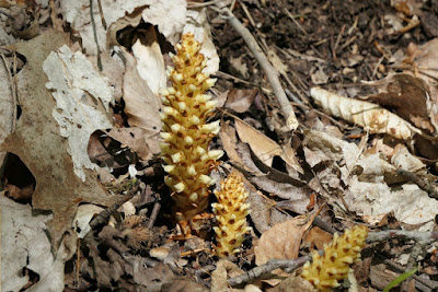
We turned around and began the climb out. Traveling a route in the opposite direction always results in new sights, such as this squaw root, a parasitic plant that feeds on the roots of oak and beech trees.
Our steps were retraced and we continued east, by passing picnickers in the grass, and took the path by the largest pond.
The birds we saw were not as easily photographed as the flowers, especially the warblers and gnat-catchers. The early scarlet tanager was an exception. Here's a photo, in the shade, of a Swainson's Thrush.
They were only migrating through, and therefore did not sing for us, unlike the melodious wood thrushes.

The trails are well maintained.
In the central part of the preserve there were deep ravines and sandstone rock formations, some an overhang,
and some impressive looming faces on the trail.
Joan and I returned to the North trailhead and our car after a bit more than four hours. We spent too much time looking to set a blistering pace, but enjoyed every minute. Visiting the eastern portion of the preserve, starting at the East trailhead, would wait for another day.

Monday, May 25, 2020

Fledgling Owls!

On the evening of May 21st or early morning of May 22nd two owlets fledged from their nest, located within a sycamore in the back yard between our house and the neighbors. (Owls are cavity nesters.) Joan spotted them and had to restrain herself from interrupting me on the bicycle rollers. As soon as I stopped, it was time to grab the camera and head outside.

The parent was observing from a small distance, less than the width of our yard from the youngsters.
One fledgling was larger than the other, but had chosen a slender tree and was barely 15 feet above the ground.
A more zoomed-in look.
Its smaller sibling had managed to climb a much larger ash tree, and was resting at least 3x higher.
A nice shot of it looking up.
Early the next morning Joan was excited to see the two parents engaged in grooming each other. By the time I got my camera they had taken a step apart, as if to say, "Nothing happening here."
With each successive morning the fledglings were higher/deeper in the woods. On the 25th we spotted a parent taking food to the large chick; we couldn't identify the prey item because the exchange was taking place on the far side of the tree.

It's been three years since we observed very young owlets, and even earlier one time the nest was predated in the middle of the night. What a howl we heard then! It makes this year's success all the more exciting.

Sunday, May 17, 2020

Iceland: The Svalvogar Circle, a Wild Finish

July 28, 2019 was our last day in Iceland with Natural Habitat Adventures, and it was a wild one. Our group would be traveling with Iceland Back Country Tours in two SUVs   capable of handling the narrow dirt tracks on the Svalvogar Circle Tour.
After breakfast in Ísafjörður we boarded the vehicles, and at the south end of the fjord plunged into Vestfjarðagöng, the longest tunnel in Iceland. This tunnel has a Y shape, and at the split the two arms change from a two-lane road to one lane regulated by traffic signals and pullouts. Driving past the fjord of Flateyri, we crossed another peninsula and took our first stop -- at least the first where I took photos -- at Þingeyri, population approximately 250, for a break at the local park,
just outside the town. Þingeyri was the first trading post established in the Westfjords.
Out in the fjord there was a fish farm.
Some folks just can't resist throwing rocks.
After Þingeyri we began our  counter-clockwise journey around the peninsula, and our stops became more frequent. (Click on the image to enlarge.)
A low spot in the Haukadalur valley
harbors marshlands. We spotted a red-throated diver with a chick in tow.
The throat color is clearer in this shot, but the chick is partially hidden.
At the same stop we glimpsed the "French Cemetery." Fleets of French fishing ships roamed the waters west of Iceland in the days of sail, so much so that the British put pressure on the Danes, who ruled Iceland at the time, to prevent a French settlement there.

The road shrank as we left Haukadalur. The track we followed was built when Elís Kjaran Friðfinnsson (1928-2008), a bulldozer driver from Kjaransstaðir farm, took it upon himself in 1973 to carve a road in the craggy mountainside, using a small bulldozer called Teskeiðin or Teaspoon! It's passable only two or three months of the year.

Sheep are a road hazard in rural Iceland, although the total number of sheep in the country recently hit a 40-year low.
It doesn't help if all they do is trot in ahead of you.
The ocean was below our little parade.
Finally the sheep found some better greenery and we left them behind.
A summer cottage.
Then we had a long stop for bird watching and scenic photography.
In this zoom-in picture there's a guillemot, cormorant, and a couple of kittiwakes.
Left middle, bottom, upper right.
Crashing waves.
Many observers.
Looking ahead from our stop. We had a nice leg stretch up to where the SUVs were parked.
After driving around the bend, we reached the lighthouse of Svalvogar, built circa 1920.
Yes, it's time for lunch at the foot of the automated lighthouse.
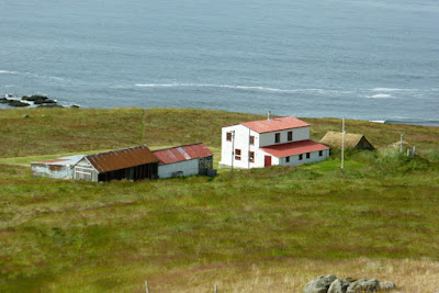
After a refreshing meal, it was time to cruise down the far side of the peninsula. A stone's throw down the road was an old farmhouse, formerly the home of the lighthouse keeper.

We stopped to admire the layers in this cliff face, the result of repeated lava flows over the eons. The Westfjords are the oldest part of Iceland, geologically speaking, are now slowly eroding while other parts of Iceland are still being built up.
Up in the cleft there's a seasonal watercourse.
Next, we reached a large side valley.
There's an active farmstead here. Social distance is measured in kilometers.
Further along we reached the low point of the tour, so to speak; traversing it is recommended only at low tide.
Our guides told us of a U.S. tourist who took a rental sedan on this route and became stuck here. He abandoned the vehicle, made his way to Reykjavik, and flew home. The rental company called when he didn't return the vehicle on time, and he told them where he'd left it. But the tides had taken it.

Kittiwakes and other seabirds nest on the far side of this block.
But we had to walk gingerly over stone and seaweed to the far side.
Rocks and seaweed.
The kittiwakes don't mind being in close quarters.
Nor were they disturbed by our presence.
This is my best side.
Just beyond, flowers thrived with a source of fresh water.
Driving on, we soon reached Route 60 and turned inland, to cross the peninsula's spine back towards Þingeyri. At the pass we took a break to admire the view.
There were hikers high up, visible through binoculars but only a handful of pixels in my camera.
We clambered back into the SUVs to take the switchbacks down into the valley.
Katherine, our NatHab guide, had a surprise in store. As we approached Þingeyri we took a turn and began to climb Sandafell Mountain, which rises 362 meters, or 1188 feet, above the town. We joined the communication towers.
It's a great view,
and we could see the small airstrip.
Looking down on the town.
We shared toasts with sparkling beverages, and congratulated Katherine on such a fine NatHab adventure.
The day was far from over. We drove back to Ísafjörður, picked up our luggage, and dashed to the airport: we were to spend the night in Reykjavik and take early flights out the next morning. At the airport I took a photo of our aircraft, through a window, after it arrived.
It didn't take long to fly to Reykjavik, about 40 minutes. Our dinner was at a restaurant that had the virtue of being near the hotel, but the drawback of being crowded and noisy. Our group managed to return to the hotel for a few hours sleep before checking out.

We were organized into two groups for the transfer to the airport, the early group and the really early group. Joan and I were in the merely early group. I had intended to claim the VAT (Value Added Tax) refund for the rain jacket I had purchased in Vik, but the line at the refund station in the airport snaked for, it seemed, miles. As it was, after going through check-in, including a brief security interview and queueing for the security inspection, Joan and I had about 20 minutes to catch our breath before boarding started. 

Fortunately, the flight home was uneventful, unlike our trip out, and we found ourselves home with our Icelandic objectives, to see the interior and the Westfjords, well met.