Our first landmark in the new van was to pass the continental plate divide, crossing from the North American plate to the Eurasian plate. The route on the Ring Road, Highway 1, took us through the small town of Selfoss, where the chess champion Bobby Fischer lived in seclusion for the last years of his life. There's a small museum about Fischer here, but we didn't have time to stop.
We continued on to the Lava Center in the small town of Hvolsvöllur. Our group had time to take in the introductory movie, and walk through the interactive exhibits, which are atmospheric and absolutely first rate. Then some of us dashed up to the observation deck atop the center.
From the roof we could see the volcano Hekla in the distance,
 |
| In July it's without its snow cap. |
Katla lies beneath a glacier, so whenever it erupts, glacial floods called jökulhlaup may burst across the surrounding countryside.
Time to move on! Farms and volcanic cones passed by our van windows.
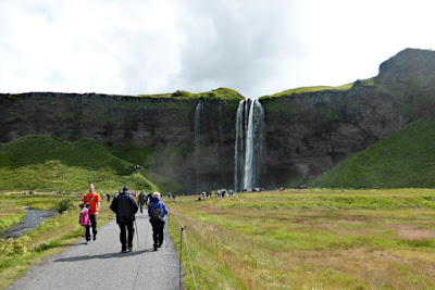
The next destination was Seljalandsfoss. ("Foss" is Icelandic for "waterfall.") This popular destination is known for approachability; you can even walk behind it.
Rain gear is recommended, but after I searched through my daypack several times I realized I must have left my rain jacket behind at the hotel in Reykjavik.
I'm going under, regardless.
I merely became damp, not soaked. The climb back out demands attention to your footing.
The next stop was Skogafoss. This thunderous waterfall
 |
| This front-on photo is from 2006. |
The view from that platform stretches out as far as the sea.
A path continues beyond the falls, becoming the Fimmvörðuháls hiking trail, 24 - 30 km. If you go far enough, you'll traverse some of the new lava flows from the famous 2010 eruption of Eyjafjallajökull.
There was no time to travel even one kilometer, as it was time for lunch down below. By this time Katherine had called the Reykjavik hotel, and there was no knowledge of my rain jacket. Fortunately, today was the last day for buying gear, and I wouldn't be alone.Next we drove to the Reynisdrangar Cliffs and the black sand beaches flanking them on either side.
The parking at the first beach was crowded.
The sands are indeed black -- and treacherous. Even in calm weather a large wave can smash in here, and people have been killed.
The spires rising out of the sea in the far left of the above photo are part of a famous cluster of rocks; folk legend says there were two trolls pulling a three-masted ship towards the shore, unsuccessfully: they were caught by the dawn sunlight and turned into stone.
Basaltic columns are exposed on the cliffs.
 |
| And people like to climb them. |
 |
| Puffins! Puffins! |
Unfortunately, the tourist fad of piling stones to mark your presence continues. Visitor poop, if you will, marring the landscape.
Some contemplated.
Barely a month after our visit a portion of the cliff fell onto the beach. Even after the debris was cleared, the east end of the beach is off-limits over concern for the stability of the remaining blocks.
Then it was a short ride to the town of Vík, the southernmost village in Iceland and an important staging area. Those of us in need had an opportunity to shop, and I picked up a red rain jacket to replace the one I'd left behind. It weighed twice as much as the old one, perhaps to better withstand Icelandic gales.
In Vík our group also took in the Icelandic Lava Show. Here harvested lava is reheated in what was originally a smelting furnace,
 |
| A behind-the-scenes tour with the owner. |
The room grew quite warm.
The presenter placed some ice in the lava's path, so we could see the difference in texture between rapidly and slowly cooled flow. (Rapid cooling produces a glassy texture, such as obsidian.)
At the end we all had a chance to smash the lava with a metal bar, and take a shard home as a souvenir.
Joan and I kept a piece, but later decided it was awkward to carry around such a sharp edged object. It's still in Iceland somewhere.
It took just a few minutes to reach the black sand beach on this side.
This beach was much less crowded, virtually empty, even though it presented the trolls and their ship at a much better angle.
After a very busy day it was time to check into our hotel. Behind us we could see the village church on a hill.
Vík lies in the path of glacial floods that occur when Katla erupts under the Mýrdalsjökull glacier. Katla last erupted in 1918, and has been showing signs of unrest since 1999. All the residents are trained to dash to the church at the first sign of an eruption. It should be high enough to survive the flood.
I did manage to fall asleep that night, Katla notwithstanding.


No comments:
Post a Comment
Comments may not appear immediately as they are moderated by the author to eliminate spam. Please, no commercial links!