Saturday (Sept. 16) was our day to hike the Iceline along with a bevy of weekenders and other hikers. Joan and I had hiked it twice in earlier years, but not documented in this blog. The initial section of our first Iceline hike was in rain, and then much of the time passed in a dense fog that thinned into nothingness by the time we reached our turnaround point. Glaciers? Valleys? It was all a slow reveal that time, a moonscape, an atmosphere of mystery, one hike we'll never forget. Today we were happy to have plenty of sunshine. Joan and I had pre-ordered trail lunches at Cathedral Mountain Lodge for 7:15, but after we finished breakfast at 7:25, the lunches weren't ready; the "breakfast chef was busy." They finally came out at 7:40. A warning: Joan ordered the vegetarian sandwich, but we later discovered that it was just the choice-of-meat sandwich without the meat, mostly bread and garnishes. We were very glad to have a hefty chocolate bar! We drove our rental car up the seasonal highway to Takakkaw Falls. That road includes two tight switchbacks that preclude long vehicles or those with trailers from making the trip; RVs of modest dimensions can manage it if they're willing to drive in reverse between the switchbacks.
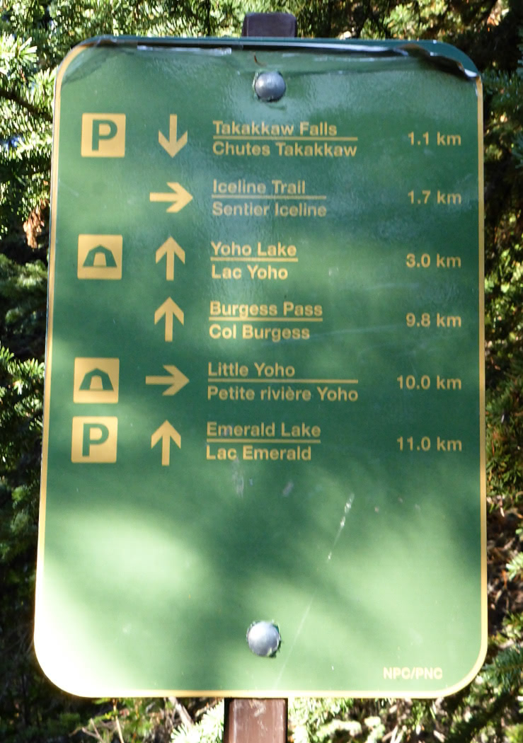
At the parking area Joan and I stepped out into bitter cold. All the signs were frost-covered and the privy seats had a coating of ice, which was quite a shock. We didn't linger to view the falls, but marched briskly towards and across the road and past the Whisky Jack hostel. We would be climbing the side of the valley opposite the falls.
Despite gloves my fingers tingled with the cold and I continually flexed them, even while holding my hiking poles, to warm the muscles and to see if they still obeyed me. I wondered if I had made a mistake by bringing my medium-weight gloves instead of the cumbersome but warmer ones. Fortunately the trail soon began to climb, with frequent switchbacks and steep segments, and the exercise brought my fingers back from the brink of numbness. There were several trail intersections,
but the Iceline was always the right-hand choice.
The trail climbed to the edge of the forested zone, and we were surrounded by mixed vegetation and rocks.
Another trail entered from the left ...
which could carry traffic to or from Yoho Lake or Emerald Lake.
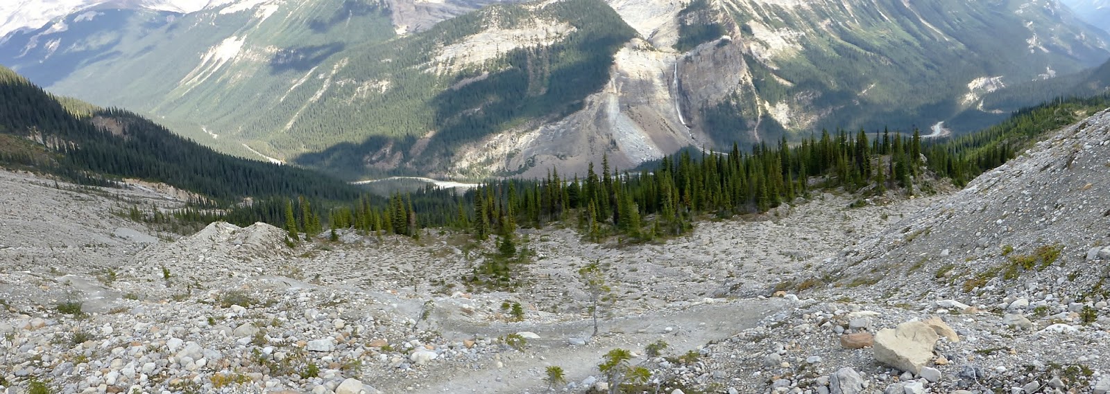
Joan and I headed north, walking deliberately up a rocky trail that rose relentlessly through the lower slopes towards the upper moraines.
This was the view back to the valley of the Trans-Canada Highway, Canadian Pacific Railway, and Kicking Horse River.
Then we were high enough to see the glacier that feeds Takakkaw Falls, which is tucked into the shadows just right of center. Click on the image to enlarge.
The trail climbed some more, and Joan and I reached the first view of a glacier on this side of the valley.
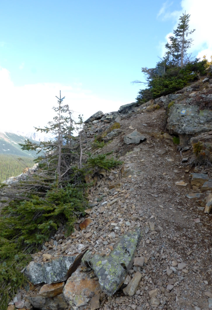
Many hikers had come out on this sun-drenched Saturday, and most were faster than we were. A few were returning from an overnight at the Stanley Mitchell hut, but most were headed in our same direction. Some were on a day trip, a few were heading up to the hut, and there were adventurous souls who had no idea what was ahead. They had simply seen the trail and set out. In this picture hikers are climbing one of the many moraines left behind by the retreating glaciers. Note the switchback, the lower hikers are headed to the left and the higher ones are headed to the right.
This shot looks back the way we've come. Note the exposed rock slabs. In places they glistened so much that they looked like flooded rice paddies.
Did I mention that most hikers were faster than we were? In the original, full-size version of this photo I can identify 17 hikers; in the smaller web version it might be tough to do! Fourteen or fifteen, perhaps?
Many photographs were taken today.
Glacial remnants and melt pools.
Joan and I crested the final moraine before the Celeste Lake cutoff and called it our turnaround point, having lunched shortly before. If you prefer a loop, the trail past Celeste Lake descends into the valley, and it's a flat (boring) walk back to the parking area. We much preferred to stay up here with the views, returning the way we had come.
Mr. Frumble concurred.
The sun had ambled over to its afternoon post, changing the light for photos on our way back.
Hikers peeked over the edge.
Joan and I had time to socialize with various people on our way back. One fellow was visiting and YouTube-ing his visits to 26 national parks in the U.S. and Canada since college graduation. A woman with a friendly dog had worked for Parks Canada until she retired, and now works in the post office in Golden. At one point we could see all the way down to the river.
A good view to a lower ridge.
Joan and I descended into the woods again.
Takakkaw Falls was now fully illuminated.
Flat, slippery pebbles and small stones embedded in mud gave us some trouble in the last mile of switchbacks. Our feet skidded more than once, but we didn't take a tumble. That's another reason for hiking poles! It seemed to take forever to our tired feet, but we neared the end of the Iceline.
We lingered for several minutes at a viewing area for the falls. With binoculars we could see two people above the top of the falls -- how did they get there? (Rock climbing is not for us!)
There was a hint of a rainbow near the bottom.
On the drive back to the lodge we saw an RV doing the backward drive on the middle switchback. They managed, although their cautious pace backed up traffic for a few minutes. Joan and I were pleased to have visited the Iceline again, even though her knee and my feet had neared their limit. I'm sure we'll do the Iceline again in a few years. The views are that good. Tomorrow will be a transit day to Kananaskis Country, with a hike to Baldy Pass.
September 15th, our last day at Lake O'Hara, had the best weather of the last three days.
Where to hike? We needed to be back in time for the 4:00 bus, so Joan and I chose All Souls Prospect and on to Opabin Plateau, rather than Wiwaxy Gap and on to Lake Oesa. We started by repeating Big Larches, but with a side trip to Mary Lake. All Souls Prospect is the triangular promontory in front of the line of peaks.
The waters of Mary Lake were reflective, green-tinted glass.
When climbing Big Larches we were favored with a pika viewing.
When not keeping lookout, the pikas were busy foraging, accumulating "haystacks" of fodder beneath the rocks for the winter months.
The All Souls alpine route branched off just before the Big Larches trail reached Schaeffer Lake.
After a few easy switchbacks the route became steep and rocky.
Sometimes it was necessary to look for the alpine blazes, two vertical yellow bars on a blue square, while at other times the path was obvious. But always up; our hiking poles were essential today.
At least the exertion kept Joan and me warm, for in the shade or at a breezy spot, with which All Souls is well endowed, it was very cold. The muddy patches bristled with long ice needles. We continued to climb.
Partway up there was a natural terrace, handy for catching the breath, adjusting boots,
and taking in the view.
Continuing on, Joan and I encountered a trail volunteer repainting alpine blazes. She was chilled, sitting on the ground with just her jacket and cap against the wind. We chatted briefly before she resumed administering fresh blue and yellow paint over faded markings. We were first to the cairn atop the Prospect, despite our deliberate pace.
Perhaps this was because we were headed counter-clockwise on the Alpine Circuit. If a hiker traverses the entire circle of alpine routes around Lake O'Hara in a day, with photographic proof at key locations including Wiwaxy Gap and All Souls, he/she can sign a register at the lodge and be awarded a pin. Most often this challenge is taken up in a clockwise direction to avoid going down from Wiwaxy Gap, making All Souls the final leg before descending to O'Hara. Looking over to Odaray Mountain.
Lake O'Hara, Wiwaxy Gap, Huber and part of Yukness Ledges.
Our solitude was brief. Peter arrived up from the Opabin Plateau, having come down from the (now defunct) Abbot Hut and across the Yukness Ledges. We marveled at his strength, and we took turns portrait-taking.
Four more arrived by the way we had come, and Joan and I had a "first lunch." It was much too cold -- my fingers were freezing -- to eat it all there. We hiked down the All Souls route towards the Opabin Plateau.
A closer look at Opabin Prospect across the way.
We stopped at the Rock Garden, a zone of tall slabs and boulders near Opabin, to finish our lunch, including the all-important Lake O'Hara cookies. A pika was sunning nearby.
The All Souls route reaches the West Opabin trail via a tall boulder waterfall from the Garden. In this photo Joan and I were partway down, and a trio at the junction were discussing. (Click on the image to enlarge.) Again the hiking poles were handy.
Looking back up from the junction.
As we started down the West Opabin trail, headed for the lodge and bus, we spotted a mountain goat browsing on a ledge below the All Souls route we'd just finished. The distance demanded binoculars.
We passed this duck on the shore of Lake O'Hara, perhaps a female, or non-breeding-plumage male, Barrow's Goldeneye.
Joan and I reached the lodge in time for a pit stop and the afternoon tea. We had greatly enjoyed our time at O'Hara, as always, despite some weather challenges. At 4:00 the bus took us 11 km to the parking area, and we drove down Kicking Horse Pass to Cathedral Mountain Lodge. Tomorrow would be our final day of hiking in Yoho National Park before shifting our activity to Kananaskis Country. Our goal: the Iceline.
The morning of September 14th was bright and cheerful -- and the landscape frosty/snowy.
The photogs loved it.
Joan and I decided to hike up to and around the Opabin Plateau today,
and leave a more alpine hike for tomorrow, when those high trails might be less snowy. This photo shows snow up at Wiwaxy Gap and the Huber Ledges,
and the snow is more widespread in the shady areas. Clouds began to form as moisture rose from the sunlit slopes.
The West Opabin trail started out through the woods.
Then it began to climb the west flank of the plateau, and Mary Lake came into view.
After traversing rocky steps and switchbacks, Joan and I neared the crest of the trail. But wait -- was that a mountain goat ahead? (Click on the image to enlarge and check the center.)
Bring up the binoculars! It sure was.
This male mountain goat was so happy to lie on the grass and chew cud in the sunshine that as long as we remained on the trail, he was unconcerned about us, even when I raised my camera. This was a great privilege he granted.
Those are horns, not antlers, meaning they are part of the animal's skull, even if covered in a sheath that darkens the color. We left him to his meal, and took the short loop out to Opabin Prospect.
It's a great view out there.
Look down from the edge and get a great view of the lakes.
Joan and I continued around the Prospect, reaching the point where the trail dips down to the Cascade Lakes.
At the edge of the water we caught sight of an American Dipper, a bird that catches all its food by striding about underwater.
After crossing the footbridge I looked back the way we had just come.
A left turn took us to the Opabin Highline trail, which meanders deeper into the plateau along a ridge. We stopped for lunch at a viewpoint that looked back at the lakes and bluff.
This stretch of trail was deserted, but across the way we spotted hikers on the Yukness Ledges trail.
Before reaching the end of the Highline we encountered two gents who told us that there were ptarmigans on the last section of the East Opabin trail, where it climbs to its namesake lake. Joan and I reached the south shore of Hungabee Lake. (That's pronounced Hun-GAH-bee, not HUNG-a-bee.) Opabin Lake is beyond the moraine that rises from the far shore, and can be reached from either side.
We encountered a pair of guys navigating, barely, by a map on their phone that had no topographic lines or lake names. They asked if this was Hungabee, and we assured them it was. Ascending the East Opabin trail, we indeed encountered ptarmigans. Seven of them, in the dry creekbed just left of the footpath. They were fluffed up against the cold,
and changing into their winter plumage.
Some would venture out of the creekbed from time to time,
and one, seemingly cast out from the group, gave us quite a stare. Was it curious, or on alert?
We, and others, approached Opabin Lake.
The water levels were low here too, similar to our visit to Lake McArthur.
To make a loop Joan and I crossed to the west side of the moraine, where another trail ascends/descends, and looked down on Hungabee Lake. The West Opabin trail is visible on the left.
We noticed a group that was traveling "cross-country" towards the All Souls trail, rather than taking the West Opabin down to the far end of the plateau, where the two intersect. Technically this may be the shorter distance but I don't think they could have saved much time. Joan and I returned to our cabin, and I caught this sunset photo on our return from dinner.
What a day, with ptarmigans and a mountain goat closeup! Tomorrow, our last day at Lake O'Hara.