Showing posts with label Mary Lake. Show all posts

Thursday, September 3, 2020

Canada (2019) Part Two -- and Post #500

Now it's time to resume reporting on our September 2019 trip to the Canadian Rockies. This is the second post and will cover the first part of our five days at Lake O'Hara; the first post is here. There was, of course, no 2020 trip.

This is also post #500, yes, the five-hundredth of this blog; the first post was in June of 2009. That's roughly one post every eight days. Who would have thought I'd stick with it so long?

Lake Oesa ...

Joan and I drove up Kicking Horse Pass and reached the parking area for Lake O'Hara in good time. A warden, Lorraine, was there to explain maps, options, the lodge bus vs the campground bus, and the 11km walk uphill to the lake if you hadn't already booked a spot -- with no guarantee of a bus ride back. No bicycles. Even so, Lorraine informed us, during the long summer weekends there were up to 140 walk-ins a day!
Joan and I had a lakeside cabin, which wouldn't be available until 1pm. We picked up a bag lunch at the lodge and took what is a traditional first-day hike for us, up to Lake Oesa. We hoped to see mountain goats at some point during our visit, but to our gleeful amazement they were visible on the Yukness Ledges from the Oesa trail.
With binos the sight was even better.
We pointed the goats out to other hikers and we all had a good look, passing binoculars around.
Along the way we admired the late-blooming flowers, including harebells, and various fungi. In September the birds were silent and the marmots were hiding, maybe hibernating already, but the autumn has its own charms. The larches turning yellow are the counterpart of the autumn colors back east.

Lake Oesa spread out before us. The weather graciously permitted us to eat our lunches perched on a flat rock, a treasured spot up here; today wasn't crowded.
Joan and I decided to return via the initial stretch of the Yukness Ledges alpine trail and the Victoria cutoff. This photo looks back at the Oesa outflow after descending to the alpine trail.
We met several people on the trail, including a German couple who got separated when she went ahead while he took photos and chatted with us. When she couldn't find him on the Yukness Ledges, she decided to pursue the Victoria Cutoff, where we also went. Then he backtracked, she spotted and called to him, and I wish I understood German ... but they went on to complete the Ledges after having hiked in from the parking area and up Wiwaxy Pass and along the Huber Ledges to reach Oesa. Whew! Young, strong, and well-trained they were.

Not far from Victoria Lake the outflow transforms into a tumbling cascade.
From here we spotted our 9th mountain goat, a solitary male.

We finished our hike by completing the loop around Lake O'Hara itself. This photo looks up from that path to the Seven Veils falls.

Then we reached cabin #4 and began unpacking. That evening at dinner we swapped stories with our table-mates about hiking glaciers, biking, and so forth, plus Lake O'Hara tales.

Opabin Prospect ...

The next day (September 9th) began with rain showers teasing us, off and on, during breakfast.

Joan and I decided to hike to the Opabin Plateau and see how the weather developed; Opabin is lower than other destinations, and it's usually easier to bail out from there. Because of the precip the kids decided to stay behind.
"We'll be fine, thanks!"
We started for the west trail, which skirts Mary Lake by just a few feet. Mount Schaffer had its head in the clouds.
This is a look at the lower part of the west trail, which hugs the bluffs of the plateau. Click on the image to enlarge, and you may spot the path, starting about 1/3 of the way up the left-hand side.
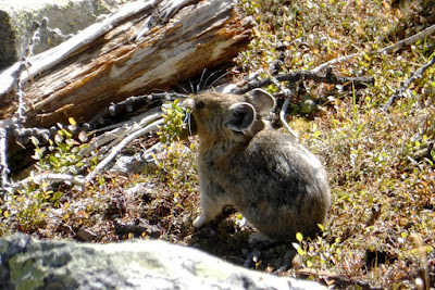
The marmots may be dozing, but the pikas were still out harvesting. They are so fast, though, that getting a sharp picture isn't easy when they are dashing back to add to their larder.
From the west trail we went across to the Opabin Prospect, which usually offers a spectacular view, but not today. The Prospect consists of large blocks with cracks and gaps in between and a sheer drop at the edge. Joan slipped on wet lichen on one slab, banging her shin, but didn't fall into a crevice or suffer any serious harm. We began walking up the plateau. This photo looks back towards O'Hara, but you can't see anything beyond our surroundings.
From above the Moor Lakes we spotted a couple of american dippers, hurrah! This bird feeds on various invertebrates by walking and swimming underwater.
Joan and I crossed the lakes
Pop down from here to cross to the central ridge.
on a footbridge and headed up the plateau on the Highline trail. Showers came and went, light and sparse, and then grew heavier and steadier. Joan and I reached our favorite rainy-day lunch spot up here, a small clump of trees split by the path, only to discover that it was already occupied. We continued past the Yukness Ledges terminus and reached Lake Opabin in a steady rain.

We paused momentarily to absorb the view, then returned and found the lunch spot open. Two of our table-mates from last night, Greg and Nancy, trod by as we ate. Joan and I were astonished to learn that they were attempting the entire Alpine Circuit today, Lake O'Hara > All Souls Prospect > Opabin Plateau > Yukness Ledges > Lake Oesa > Huber Ledges > Wiwaxy Gap > Lake O'Hara. Bad weather for it, we thought, but perhaps this was their last chance.

We returned to Lake O'Hara by the east trail, boring compared to the west but only a stone's throw away, and hence the quicker choice. Back at the cabin we spread things out to dry -- there are never enough hooks -- and at dinner had a new set of table-mates. At O'Hara your dinner partners are changed by the management nightly, unless you have a request otherwise. Joan calls it speed dating.

We'll see what tomorrow's weather brings. 

Wednesday, February 14, 2018

Smoke and Snow: All Souls Prospect

September 15th, our last day at Lake O'Hara, had the best weather of the last three days.
Where to hike? We needed to be back in time for the 4:00 bus, so Joan and I chose All Souls Prospect and on to Opabin Plateau, rather than Wiwaxy Gap and on to Lake Oesa.

We started by repeating Big Larches, but with a side trip to Mary Lake. All Souls Prospect is the triangular promontory in front of the line of peaks.
The waters of Mary Lake were reflective, green-tinted glass.
When climbing Big Larches we were favored with a pika viewing.
When not keeping lookout, the pikas were busy foraging, accumulating "haystacks" of fodder beneath the rocks for the winter months.
The All Souls alpine route branched off just before the Big Larches trail reached Schaeffer Lake.
After a few easy switchbacks the route became steep and rocky.
Sometimes it was necessary to look for the alpine blazes, two vertical yellow bars on a blue square, while at other times the path was obvious. But always up; our hiking poles were essential today. 
At least the exertion kept Joan and me warm, for in the shade or at a breezy spot, with which All Souls is well endowed, it was very cold. The muddy patches bristled with long ice needles. We continued to climb.
Partway up there was a natural terrace, handy for catching the breath, adjusting boots,
 and taking in the view.
Continuing on, Joan and I encountered a trail volunteer repainting alpine blazes. She was chilled, sitting on the ground with just her jacket and cap against the wind. We chatted briefly before she resumed administering fresh blue and yellow paint over faded markings.

We were first to the cairn atop the Prospect, despite our deliberate pace.
Perhaps this was because we were headed counter-clockwise on the Alpine Circuit. If a hiker traverses the entire circle of alpine routes around Lake O'Hara in a day, with photographic proof at key locations including Wiwaxy Gap and All Souls, he/she can sign a register at the lodge and be awarded a pin. Most often this challenge is taken up in a clockwise direction to avoid going down from Wiwaxy Gap, making All Souls the final leg before descending to O'Hara.

 Looking over to Odaray Mountain.
 Lake O'Hara, Wiwaxy Gap, Huber and part of Yukness Ledges.
Our solitude was brief. Peter arrived up from the Opabin Plateau, having come down from the (now defunct) Abbot Hut and across the Yukness Ledges. We marveled at his strength, and we took turns portrait-taking.
Four more arrived by the way we had come, and Joan and I had a "first lunch." It was much too cold -- my fingers were freezing -- to eat it all there. We hiked down the All Souls route towards the Opabin Plateau.
A closer look at Opabin Prospect across the way.
We stopped at the Rock Garden, a zone of tall slabs and boulders near Opabin, to finish our lunch, including the all-important Lake O'Hara cookies. A pika was sunning nearby.
The All Souls route reaches the West Opabin trail via a tall boulder waterfall from the Garden. In this photo Joan and I were partway down, and a trio at the junction were discussing. (Click on the image to enlarge.) Again the hiking poles were handy.
Looking back up from the junction.
As we started down the West Opabin trail, headed for the lodge and bus, we spotted a mountain goat browsing on a ledge below the All Souls route we'd just finished. The distance demanded binoculars.
We passed this duck on the shore of Lake O'Hara, perhaps a female, or non-breeding-plumage male, Barrow's Goldeneye.
Joan and I reached the lodge in time for a pit stop and the afternoon tea. We had greatly enjoyed our time at O'Hara, as always, despite some weather challenges.

At 4:00 the bus took us 11 km to the parking area, and we drove down Kicking Horse Pass to Cathedral Mountain Lodge. Tomorrow would be our final day of hiking in Yoho National Park before shifting our activity to Kananaskis Country. Our goal: the Iceline.

Tuesday, January 20, 2015

CR2014: Big Larches and Odaray Grandview

On July 23rd Joan and I decided to hike to Lake McArthur by our favorite route, the Big Larches Trail. We find this trail more scenic than the eroded, switchbacked trail that leaves from the Elizabeth Parker Hut. To help you follow today's meanderings, here is a map courtesy of Parks Canada (click to enlarge).

The Big Larches trail emerges from the woods surrounding Lake O'Hara and Mary Lake and skirts the edge of a vast rockfall, where it begins to climb.
Eventually it turns to the right and dives deeper into the larches for which the trail is named.
We passed the trail to All Souls Prospect on our left, then soon, at the outlet from Schäffer Lake, merged with the trail arriving from the Elizabeth Parker Hut. From here, Joan and I took the route to Lake McArthur that passes near the sign-in for the Odaray Highline Trail, established for the benefit of wildlife passing through the choke point of McArthur Pass. To quote Parks Canada,
Adjacent to McArthur Valley and contributing to the corridor is the Odaray Plateau. Habitat here is used seasonally by several species, including grizzly bears and mountain goats. The plateau is closed in summer to protect habitat and to limit disturbance in the wildlife corridor.
The Odaray Highline Trail cuts across the pass, skirting the closed zone. There is a voluntary program to limit the number of groups that use this trail; when we were there, the check-in station requested no more than four groups per day until August 15th, and no more than two after that. This makes grabbing an Odaray Grandview slot difficult, because hikers in the campground can get started earlier then hikers from the lodge. Note: this Parks Canada web page, updated September 2nd, 2014, now requests only two groups until August 15th, and zero after that.

Because the program is only voluntary, we've seen lots of people violating it, but we do not. The bears were here first. This means that we haven't been able to visit Odaray Grandview for several years. (Many wonder at the efficacy of a voluntary program: how much does it really accomplish?)

This year we were lucky. After passing the guard marmot
we checked the sign-in book, and there was an open slot for us! Lake McArthur could wait for another day.

Wanting to do the right thing, we waited to see if any other hikers wishing to take the Highline would show up. We could form a single group, you see, and all could go. And not long afterwards, a group of two moms and four kids arrived.
They decided they would join us. The Highline, after crossing the pass, makes a right turn, wanders through some rocks, and then begins a gentle climb on the lower slopes of Odaray. The view begins to open up.
Then the trail arrives at the point where the Odaray Plateau is closed. The only way to go is up, to the Grandview, on a steep trail that occasionally demands a handhold. However, it's not exceptionally long, and the view at the top is rewarding. Joan and I pulled ahead of the family group, but for some reason I didn't take any photos until we got to the top.

There, the view is a jaw-dropper.
The valley on the left holds the fire road down to the TransCanada Highway. In the middle is Lake O'Hara, surrounded by peaks. A bit further right is Schäffer Lake and a meadow. Visible at far right, in its bowl, is Lake McArthur. Zooming in, my camera can even pick out hikers atop All Souls Prospect!
There are plenty of loose stones of all sizes on the Grandview's bench. Rock piles created by hikers and climbers have gone far beyond simple cairns in the last decade.
Joan provides scale for this stone windbreak, useful for staying warm and keeping sandwiches in hand when winds come howling up the pass.
We ate our lunch up here, and never saw the family group. On our way back along the bench, before the trail starts seriously descending, we saw them arriving at the descent point from the other direction along the bench. Hmm. We had never been over to the other side. Perhaps something was there?

Yes indeed, a spectacular look into the Duchesnay Basin. How could we have overlooked this?!
In the foreground, there's the best view of the Morning Glory Lakes that I've ever had. Beyond a rise, you can see much of Linda Lakes. On the far side of the basin rises Cathedral Mountain, and below it the mixed rock faces and trees of the Cathedral Prospect, which we've hiked before.

On our return descent we caught up to the family group, and we all stopped for a snack. Then we spotted ptarmigans, at least one parent,
and one chick.
We continued retracing our steps to our cabin, and enjoyed another fine dinner at the lodge. On an evening lakeside stroll, I took several photos of the Sufi Bench,
which I've discussed in detail at the end of this post. My photos of the bench allow Bob to keep an eye on its condition.