Saturday, January 25, 2020

Iceland: Birds, Sculptures, Songs, and Stones

The next day, July 22nd, began with a drive to Höfn, a fishing port on the Hornafjörður fjord and the second largest town in southeastern Iceland. We tourists noticed that many of the bridges on Highway 1, the Ring Road, in this part of Iceland are single lane (one way at a time) structures. The Transportation Department estimates that with its current budget all will be replaced with double lane bridges ... by 2050!

Solveig drove us to an observation point near the mouth of the harbor.
 The town lay behind us.
Our gaze was directed at a beach carpeted with red knots in breeding plumage, a shorebird of the High Arctic that has been experiencing a population decline.
For a closeup, a shot of the handbook:
A related shorebird, the dunlin, was also visible here.

The observation circle included a memorial to those from this fishing town that have been lost at sea over the centuries.
The next segment of the Ring Road took us near the shore, past deep valleys, and across high bluffs. Here are photos from two of the observation stops.
A pullout to observe birds and landscape.
 I have no good bird pics from here, but will sheep do?
On to the second stop.
I hope that slope holds.
The tiny white specs nesting along the shore, near the right edge, nestled large black-and-white eider ducks. Click on the image to enlarge.
Then we visited Djúpivogur, a small harbor town traditionally dependent on fishing.
Our first stop was near the Langabúð, one of the oldest commercial buildings in Iceland.
We had a chance for a rest stop and a brief leg stretch, and then a local guide joined us to lead a walking tour.
 
Across the harbor was a pyramid mountain, Búlandstindur, 1069 m high, dominating the fjord (Berufjörður).
Our group walked to Steinasafn Auðuns/Audunn's mineral collection.
The owner was there to give us a tour; he didn't speak English but our guide (left below) translated for us.
A three-part photo of what you can find when cracking open and polishing an ordinary looking stone.
Adunn is known for disappearing into the mountains and evaluating rocks. Here is some of his polishing equipment for smaller pieces.
Hare bells on the next phase of our walk.
We arrived at the famous egg sculptures.
When the fishing industry packed up and left Djúpivogur a long pipeline that transported the catch to a rendering station was torn up for scrap metal. However, the concrete plinths, or stands, that supported the pipeline remained. What to do with them? Noted local artist Sigurður Guðmundsson designed a series of 34 large granite eggs, each reflecting the shape of the egg of a bird species that nests here. They're all the same size, except for that of the red-throated diver, the official bird of Djúpivogur, which is larger. More info here.
Unveiled in August 2009
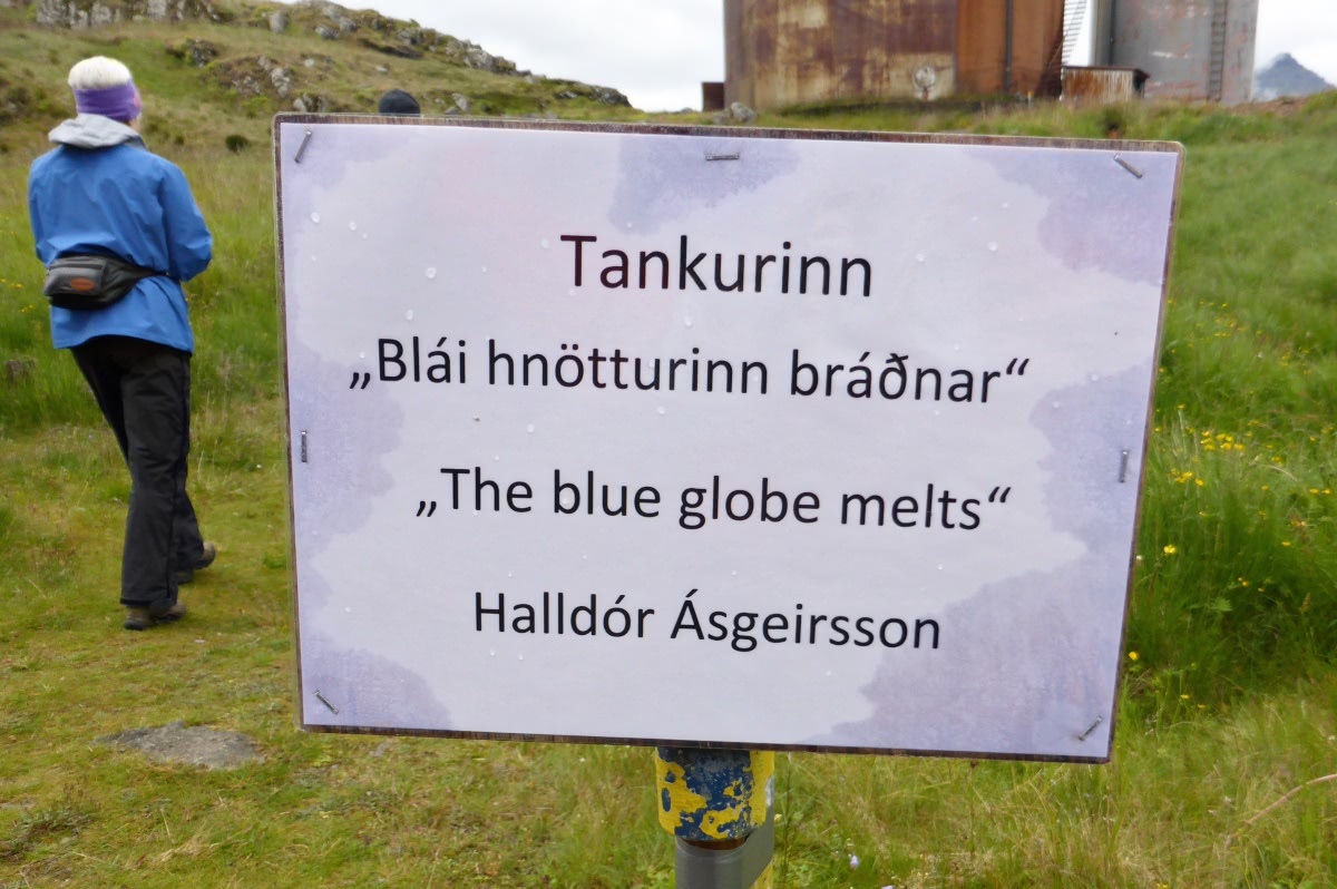
At the old rendering station one of the storage tanks for fish oil has been cleaned up, and we attended a concert there.
 Our performance hall.
On the inside, after the concert.
The door is open to let light in!
The soloist's voice took full advantage of the enclosed acoustics here as she sang traditional Icelandic songs. During the recital the only illumination was from the candles you see in the above photo, plus a small globe of the earth lit from within. Afterwards she received a reverberating round of applause.

For such a small town there has been a flurry of activity in Djúpivogur. Our guide told us that it's the only small town in Iceland that has seen population growth lately, due to young people returning to start enterprises here.

It was about time for lunch and the afternoon journey. In the next post! 


Sunday, January 19, 2020

Iceland: Lava, Glaciers, and Lagoons

On Sunday, July 7th, our NatHab group headed east from Vik. Our first stop was the Eldhraun lava flow, created by a 1783 planet-cloaking volcanic eruption, old enough to be carpeted with moss and other low-growing foliage. You can find it on Google Maps by specifying "Scenic Green Lava Walk, Iceland."
BIG -- 565 km²!
A trail led to the viewpoint. Watch your footing; there are few sturdy fences or guardrails. In Iceland it's generally assumed you're intelligent enough to stay on the path and read the signs. Yesterday's walk behind the Seljalandsfoss waterfall might not have been allowed in many other developed countries.
From the top, looking inland.
Looking the other way.
Solveig drove our trusty van on,
and we passed from South Iceland into East Iceland before we reached our next destination, a glacier walk. Those who preferred went on a hike to a lovely waterfall while the rest, including Joan and me, went for the glacier.

The massive Vatnajökull icecap covers 7,000 km² (3100 mi²), and we had stopped where several glacial tongues descend towards the low country. This summer only the Falljökull glacier was open for business; the others were either blocked by lagoons created as the glaciers retreated in the face of climate change, or because climbers are threatened by instabilities in the rock faces.

We were introduced to our crampons and glacier suits by the climbing guides, then climbed aboard a van for a short drive to the parking area. We were soon walking past a lagoon that hadn't been there twenty years ago. Glacier scouring marks were visible on the bare rock portions of the valley.
We drew closer to the glacier,
but put our crampons on only after we'd passed the lagoon and crossed to the other side of the outflow.
We gained altitude with frequent stops and explanations from our guide. Soon the view to the south opened up.
There were several groups on the glacier, kept separate by the guides. In this photo we're pausing before the transition from dirty ice to clean ice.
We're near our high point now. Given that none of us were experienced ice climbers, and our day had a packed schedule, we didn't tackle the wall ahead.
No close approach to the seracs, which was fine by us.
Our guide took photos, and in this one Joan and I make a rare appearance.
We retraced our steps down the ice, across the moraine and stream, along the lagoon, and finally reached the glacier van. It dropped us off at the lunch restaurant, where we were reunited with the waterfall hikers.

Time to move on! We paused when we reached the Hofskirkja Church,
the most recent church on this site, built in 1884. It is the last church constructed in the old Icelandic style, with stone walls and a stone slab roof, all covered in turf. There are six traditional churches preserved in Iceland as national monuments and this is one.
The adjacent graveyard features raised resting places.
You can see it is starting to rain a bit.
This packed day of adventure with NatHab wasn't over yet. Down the road was Fjallsárlón Iceberg Boat Tours. Despite the light rain, everyone in our group was ready to go, once we wriggled into life vests and sturdy rain jackets and otherwise got ready for a damp and chilly ride.
The guests are responsible for their own rain paints.
From the headquarters there was a walk down to the beach and the zodiacs.
Note the low ceiling.
Plenty of icebergs floated on the downwind side of the lagoon,
orphan bits of glacier.
Two zodiacs were required for our group. My boat, of course, was the leader.
When the air bubbles have been squeezed out of the ice, small quantities lose their blue tint and become transparent.
The zodiacs cruised by the glacier face at a respectful distance. I saw, and all heard, a small block splash into the lagoon. The driver told us of a group of horsemen who in the last century were crossing the glacier, but were caught in a storm. One of them became lost and did not make it home; long distance travel was risky in Iceland! Years later that rider and horse became visible as the section of glacier that had entombed them reached the lagoon. We also had a surprise at the far side of the lagoon -- if you don't mind a spoiler, click here.

From here it was a short drive to our digs for the night, the Fosshotel Glacier Lagoon.
The view from our window.

We were ready for dinner and a good rest after a very busy very outdoors day.

Monday, January 6, 2020

Iceland: Waterfalls and Volcanos

Katherine and Solveig managed the inaugural loading of our  NatHab group into the van with aplomb. We began our departure from Reykjavik, but soon the van's microphone or its related equipment began to malfunction, making it difficult to hear Solveig's narrative. So we parked at a location for a van swap, and as you can see in this photo, the suburbs of Reykjavik are being built practically non-stop.
Our first landmark in the new van was to pass the continental plate divide, crossing from the North American plate to the Eurasian plate. The route on the Ring Road, Highway 1, took us through the small town of Selfoss, where the chess champion Bobby Fischer lived in seclusion for the last years of his life. There's a small museum about Fischer here, but we didn't have time to stop.

We continued on to the Lava Center in the small town of Hvolsvöllur. Our group had time to take in the introductory movie, and walk through the interactive exhibits, which are atmospheric and absolutely first rate. Then some of us dashed up to the observation deck atop the center.
From the roof we could see the volcano Hekla in the distance,
In July it's without its snow cap.
And closer was Katla.
Katla lies beneath a glacier, so whenever it erupts, glacial floods called jökulhlaup may burst across the surrounding countryside.

Time to move on! Farms and volcanic cones passed by our van windows.
The next destination was Seljalandsfoss. ("Foss" is Icelandic for "waterfall.") This popular destination is known for approachability; you can even walk behind it.
Rain gear is recommended, but after I searched through my daypack several times I realized I must have left my rain jacket behind at the hotel in Reykjavik.

I'm going under, regardless.
I merely became damp, not soaked. The climb back out demands attention to your footing.
The next stop was Skogafoss. This thunderous waterfall
This front-on photo is from 2006.
is flanked by steps that snake up to an observation deck.
The view from that platform stretches out as far as the sea.
A path continues beyond the falls, becoming the Fimmvörðuháls hiking trail, 24 - 30 km. If you go far enough, you'll traverse some of the new lava flows from the famous 2010 eruption of Eyjafjallajökull.
There was no time to travel even one kilometer, as it was time for lunch down below. By this time Katherine had called the Reykjavik hotel, and there was no knowledge of my rain jacket. Fortunately, today was the last day for buying gear, and I wouldn't be alone.

Next we drove to the Reynisdrangar Cliffs and the black sand beaches flanking them on either side.
The parking at the first beach was crowded.
The sands are indeed black -- and treacherous. Even in calm weather a large wave can smash in here, and people have been killed.
The spires rising out of the sea in the far left of the above photo are part of a famous cluster of rocks; folk legend says there were two trolls pulling a three-masted ship towards the shore, unsuccessfully: they were caught by the dawn sunlight and turned into stone.

Basaltic columns are exposed on the cliffs.
And people like to climb them.
Seabirds were everywhere in this nesting season, floating on the water, burrowing into the greenery on the cliffs,
Puffins! Puffins!
 and on the rocky promontories. (Click on the image to enlarge.)
Unfortunately, the tourist fad of piling stones to mark your presence continues. Visitor poop, if you will, marring the landscape.
Some contemplated.
Barely a month after our visit a portion of the cliff fell onto the beach. Even after the debris was cleared, the east end of the beach is off-limits over concern for the stability of the remaining blocks.

Then it was a short ride to the town of Vík, the southernmost village in Iceland and an important staging area. Those of us in need had an opportunity to shop, and I picked up a red rain jacket to replace the one I'd left behind. It weighed twice as much as the old one, perhaps to better withstand Icelandic gales.

In Vík our group also took in the Icelandic Lava Show. Here harvested lava is reheated in what was originally a smelting furnace,
A behind-the-scenes tour with the owner.
and after an introductory talk about lava, it was released in our direction.
The room grew quite warm.
The presenter placed some ice in the lava's path, so we could see the difference in texture between rapidly and slowly cooled flow. (Rapid cooling produces a glassy texture, such as obsidian.)
At the end we all had a chance to smash the lava with a metal bar, and take a shard home as a souvenir.
Joan and I kept a piece, but later decided it was awkward to carry around such a sharp edged object. It's still in Iceland somewhere.

It took just a few minutes to reach the black sand beach on this side.
This beach was much less crowded, virtually empty, even though it presented the trolls and their ship at a much better angle.
After a very busy day it was time to check into our hotel. Behind us we could see the village church on a hill.
Vík lies in the path of glacial floods that occur when Katla erupts under the Mýrdalsjökull glacier. Katla last erupted in 1918, and has been showing signs of unrest since 1999. All the residents are trained to dash to the church at the first sign of an eruption. It should be high enough to survive the flood.

I did manage to fall asleep that night, Katla notwithstanding.