Overnight the Explorer edged westward, towards the area of the lost Franklin Expedition (1845), but ice began to clog the channel of Lancaster Sound, so we reversed course and spent August 3rd cruising off Devon Island, on the north side of the Sound.
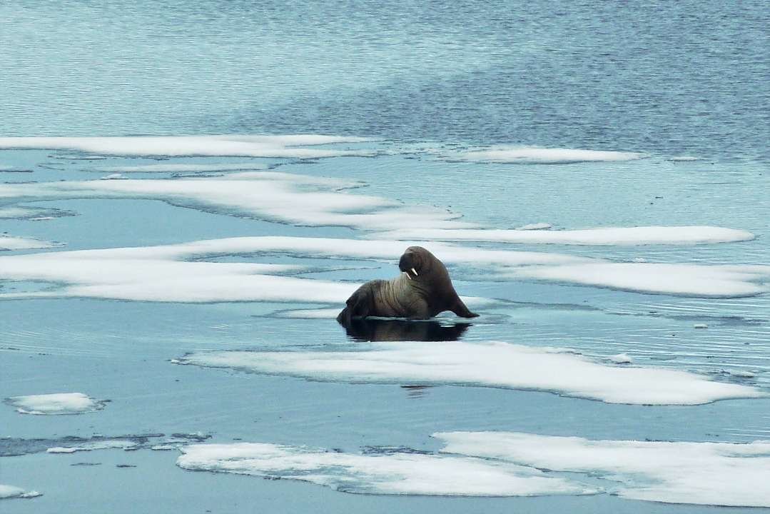
Lancaster Sound is one of the Arctic's most biologically productive marine areas. Our first sighting began about 7:30, when the bridge spotted walrus on the ice. The Explorer crept along slowly, not disturbing the animals. Although we could chatter away on the bridge, especially to guide newcomers' focus towards the walrus, those outside on the bow communicated in whispers alongside the clickity-click of cameras in burst mode. With binoculars we were able to discern that it was a pair of walrus on the little chunk of ice.
At 8:15 I was able to take this picture.
When the camera zooms in, you can see that the walrus facing us has only one tusk (click on the photo to enlarge). Walrus use their tusks for foraging on the sea floor and to haul out onto the ice, so they are prone to damage.
This was a perfect wildlife spotting in the Lindblad tradition: excellent viewing for the guests, staff, and crew without disturbing the animals.
Captain Kreuss gradually backed the Explorer away from the walrus and we then began working our way through thicker ice.
Roughly two hours later, we encountered another walrus, this time with two tusks.
The ice on which he rested was gradually sinking below the surface under the weight of his frame. Male Atlantic walrus average 2,000 pounds; the females about two-thirds of that.
This walrus saw an opportunity for lying on his back in the water.
About 1:00 pm we encountered an unconcerned bearded seal. I guess we didn't look like a polar bear. After three days of Thanksgiving turkey, I wonder if I don't look like the seal.
Half an hour later, we were visiting another walrus. At least, we thought it was only one walrus.
I missed the shot, but another guest captured the revelation that this was a mother and baby walrus.
Soon after they slid into the water and were gone from sight.
By now we were deep enough into Maxwell Bay to see the headlands. We were also a stone's throw from 75° N, and this would be the northernmost point of our journey.
The Explorer pivoted so that we could survey the action taking place on a broad sheet of ice between the bluffs of Maxwell Bay and the open water. We eagerly followed the progress of a mother polar bear and her two cubs, through binoculars. This is how it looked to my camera (click to enlarge).
Further to the left, a male was hunting along the edge of the ice. There were seals here, but they could easily see this guy coming.
He took a jump from one patch of ice to the next and missed. I didn't capture the leap, but here he is stretched out ignominiously afterwards.
We didn't leave the ship today, but we saw a lot. Lectures (The Franklin Expedition: The Boys on Beechy, The Evolution of the Arctic Submarine) were offered too, but frequently interrupted by wildlife announcements from the bridge.
August 2nd began with a "face check" -- a face for every passport and a passport for every face -- by Canadian immigration officials, required before landing at Pond Inlet, or, in Inuktitut, Mittimatalik, which means "the place where Mitima is buried." Pond Inlet is on northern Baffin Island, at 72.7° N.
There was one other boat in the harbor when we arrived.
The dry lander gave us an elegant disembarkation.
Nearby, these sleds were stacked neatly for the summer.
Every photographer took a picture of the stop sign in Inuktitut lettering.
There were two guided options for the morning, a natural history/hiking option and a cultural tour. Joan and I joined the natural history group. As we started out of town I took this photo looking back, which reveals one cultural difference -- the buildings are much less colorful than the ones in Greenland.
Soon after leaving town our route descended onto the beach.
Just off the beach was a group of sled dogs, furloughed for the summer.
Summertime is pretty boring, and even we were as long as we didn't get too close.
Our group began to spread out almost immediately.
At one point we passed some whale vertebrae.
Our guide, Rebecca, was cheerful and knowledgeable about life in Pond Inlet, but not an archaeologist. She is from Pond Inlet but now spends only summers there; the rest of the year she lives in Ottawa.
We reached Salmon Creek, and the remains of Thule culture dwellings.
Just upstream on the creek there was camping going on, for hunting/fishing/just getting away.
A small bus arrived to take us back into Pond Inlet, after a brief wait that allowed me to photograph some arctic wildflowers.
On arrival in Pond Inlet we first stopped at the library/cultural center, named Nattinnak from the Inuit word for the tabular icebergs of Eclipse Sound. The building was constructed to resemble these icebergs.
Nattinnak offers computer access, a library, a small performance space, and a modest but well-executed museum. Unfortunately, I have no photos from the inside.
On our way back to the landing, we passed by a building of the Nunavut Arctic College. Founded in 1968 as a vocational training school, it's a Crown corporation (a state-owned enterprise) funded by the Government of Nunavut, with three campuses and 24 learning centers.
Then our morning in Pond Inlet was over, and we sailed into Eclipse Sound.
We passed several nattinnak,
and the boat from early this morning.
Afternoon tea was served on the back deck instead of in the dining room. A special halibut-based snack was on offer.
Behind us several glaciers were flowing into the sea.
On the starboard side, a dry land.
At 7:00 pm, on this desiccated, rocky shore, we saw our first polar bear of the trip, fifteen days in. Binoculars were necessary. This photo was taken with maximum zoom and cropped.
Given that polar bears prefer to hunt on sea ice, a bear on land is a hungry bear. Later on we thought we were seeing a small herd of musk ox near the shore, but when we drew closer we saw that they were "polar barrels" -- abandoned 55-gallon drums. Oops.
After dinner we reached Bylot Island, Canada's 17th largest island, and part of the Sirmilik National Park. Much of the island is also a migratory bird sanctuary, and Cape Hay, at the northwestern tip, is one of its three IBAs (Important Bird Areas), hosting large populations of thick-billed murres and black-legged kittiwakes. We approach Cape Hay.
The murres and kittiwakes nest on the cliffs, avoiding predators. Here is a cluster of murres (click on the photo to enlarge).
My pictures of swarms of birds in flight are almost invariably out of focus. The sun was low and there was a high haze. The next photo has one kittiwake in the lower right.
In this shot, birds are both on the cliffs and flying in front of them. Note one of many small waterfalls on the cape, embedded in the dark area.
The camera, with the lighter sky background, was able to freeze the birds in this picture.
This is my best closeup of the murres.
By now it was almost 10:30, and although the sun refused to set, it was time for me to retire for the night.
Wednesday, July 31st. Sunrise: already up. Sunset: never went down. So stated the daily program. We had crossed 70ºN, heading for the archaeological site of Qilakitsoq, famous for the 1972 discovery of the Greenland mummies. It sits on the Nuussuaq Peninsula, the south shore of Uummannaq Fjord.
Soon after the the dining room opened for breakfast the bridge spotted a group of four fin whales.
The camera and binocular brigades were soon out on the bow, the bridge, or the deck atop the bridge.
This was the best photo I took.
The daily program described Qilakitsoq as a wet landing (stepping into water), but after a reconnaissance by zodiac the dry lander was pressed into service. (This photo was taken later while departing).
Joan and I attached ourselves to the small group to be led by Ian Bullock.
This spot was a small cove with grasses and brushy greenery, backed by tall stone walls.
Those who didn't wish to challenge the terrain were treated to zodiac rides.
Hidden in the brush were flowers, including this large-flowered wintergreen.
Ian spotted an arctic fox den and described its contents, including the remains of seabirds.
This location must have offered good hunting, for there were the remains of Inuit winter houses. Also, some of the plants offered a source of vitamin C.
There were several graves, built from piled stones.
Skulls and large bones were easily visible.
While we were exploring this lower ground, other groups were coming and going to the site where the Greenland mummies were discovered, up among the cliffs.
As you can see in the above photo, the climb up is along open, easily traversed stretches of rock, requiring only footgear with good gripping soles. Once you reach the top there is more clambering amongst rocks to reach the actual gravesite.
After one or two final squeezes between boulders, followed by a rock hop, the gravesite where the mummies were discovered is reached. Vincent "Vinnie" Butler, an Irish archaeologist, had joined the Explorer in Kangerlussuaq, and was on hand to assist and explain. He's the one in the red cap.
This is a good view of one of the graves. The gloved figure in the corner is Vinnie.
There were other gravesites along the route.
It was a life of extremes here: extremely dependent upon the sea, extremely cold, extremely unforgiving of weakness, sickness, or accident. But human beings can be extremely tough, too.
We returned to the warmth of the Explorer for lunch, after which we were to visit the town of Uummannaq on Uummannaq Island, a very short sail away in Uummannaq Fjord. We did get close ...
but the wind had been picking up all morning, and the floating docks on the island were heaving; the zodiac ride would have been very rough. We watched through binoculars as we sailed on by.
While prowling among the bulletin boards on the ship I took this photo of a list of terms in Greenlandic (click to enlarge).
That evening at dinner my susceptibility to seasickness began to kick in. At first everything was OK, but the dining room is towards the bow and pitches more than midships. By the end of the meal I was feeling unsettled and decided to skip dessert (a Manjari chocolate torte, sigh!) to return to the cabin, take a seasickness pill, and lie down. By morning everything was better ... both me and the ocean.
August 1st was spent entirely at sea, traversing Baffin Bay headed towards Baffin Island in arctic Canada. We were traveling a bit north of west, so the sun continued to be up twenty-four hours a day. Joan and I spent a lot of time visiting the bridge, of course, but there were also a host of lectures:
- Plate Tectonics and the Geology of Greenland and Baffin Island
- Exploration of Extreme Underwater Environments (Captain Fred McLaren)
- Arctic Wildlife: From Midge to Muskox
- Arctic Landings Briefing
- Aboriginal Arctic People: The Amazing Inuit
- The Polar Explorer: How Melting Sea Ice in the Polar Regions Will Affect Us All
By the time dinner was finished, we were sailing along the coast of Baffin Island, heading towards its northwestern tip.
Tomorrow we would visit Pond Inlet, but for now, we admired the view.