Showing posts with label national geographic explorer. Show all posts

Saturday, January 25, 2014

Arctic Journey: Iqaluit, Ottawa, and Home

After three weeks and a few days aboard the Explorer, beginning in Reykjavík, it was time to leave. The ship had anchored well off from Iqaluit, the capital of the Canadian province of Nunavut; from Google Earth you can see that the bottom shelves and narrows rapidly.
My adrenaline level zoomed when I saw our luggage zooming for shore at full speed, piled high on zodiacs. Fortunately the weather was benign today, and everything and everyone made it to dry land.
We had some time in Iqaluit before our charter flight to Ottawa. The Unikkaarvik Visitor has many displays of Arctic life and artifacts; this polar bear is in a diorama.
These walrus carvings are made of whalebone.

A walrus.

The dancing polar bear sports this explanatory legend.
The bear himself was difficult to photograph because of the multiple reflections bouncing around his display box. But I had to include this anyway.
And I love seeing the world-view encapsulated in this Inuit seasonal calendar (click to enlarge).
The raven came first.
Joan and I then visited the Nunatta Sunakkutaangit Museum next door, but we were running out of time. Joan purchased a pair of earrings, beluga whales carved out of musk ox horn, at the museum gift shop.
The bus was preparing to leave for the airport, so we were fortunate that the attendant allowed us to throw cash on the counter and run.

At the airport the guests identified their luggage outside the bus, and made certain that all their luggage was there. Then it was time to amuse ourselves in the small airport, waiting for the charter flight of arriving guests to land, and be serviced and refueled before we could board for Ottawa. We would fly over the entire length of Quebec from north to south:
Ottawa, whose location was vague to us before this trip, straddles on the border between Ontario and Quebec.

Our plane taxied to the charter corner of the Ottawa airport, where we boarded buses to take us to our hotel, the Fairmont Chateau Laurier. This elegant limestone structure, opened in 1912, is located in the center of downtown, close to the National Gallery, riverside paths, the Canadian History Museum, the Library of Parliament, and the Parliament Building. After dinner, Joan and I took an extended stroll exploring a section of the riverfront, past the Peace Monument and around the Parliament. A crowd was gathering for a light-and-sound show to be projected onto the front of Parliament, but it wasn't going to start until later, and Joan and I needed to be up early the next day for our flight to Toronto and then home. We were impressed by Ottawa, even though we saw very little of it, and decided it would be a worthwhile destination in the future.

In the morning the bus to take the early round of guests to the airport became lost on its way to the hotel, but we were bundled into taxis and made it to the airport in good time. The transfer in Toronto to our Columbus flight was interesting; the Ottawa-Toronto leg was a domestic Canadian flight, so we passed through U.S. customs, passport control, and security in Toronto. The luggage transfer was absolutely painless: picking up and then dropping off the luggage again wasn't necessary. There was a large waiting hall in front of the U.S. security lines, with large monitors. You simply waited for your name to appear on the monitor, and when it did you did you were free to enter the line. We never had to touch our luggage in Toronto. Wonderful!

We arrived back in Columbus on time, after three and a half weeks of exploration. The Arctic Journey had been stunning in its beauty, full of history, and packed with wildlife. Now being back home was wonderful too.


Sunday, January 19, 2014

Arctic Journey: Butterfly Bay, Monumental Island, Lower Savage Islands

Butterfly Bay
August 9th began with a sunny visit to Butterfly Bay, on the Hall Peninsula of Baffin Island.
Soon after landing I took this photo, which covers only a small portion of the view. Numerous small streams, originating in the melting snow, cross a rocky plain.
After our group had worked its way forward across streams and rocky humps, this was the view looking back towards the ship.
As we tramped further away, the ship grew smaller, and the stone hillocks grew taller.

We reached a high point and gazed around.
In this video from the top, you'll see that arctic bugs were out today. These didn't bite but they could end up in your ears, eyes, or nose. I wore a net over my hat.

Just outside the bay, there were plenty of icebergs to admire.
We returned to the shore, and both staff and guests worked to clear the beach of several sacks' worth of man-made debris, including plastic shards, plastic fishing floats, plastic fishing nets, and such.

On our return to the ship I took this photo of a map showing our course from the start of this second leg of our journey at Kangerlussuaq to here, at Butterfly Bay (click to enlarge).

Monumental Island
Then the Explorer sailed for Monumental Island, named indirectly for Sir John Franklin, leader of a famous doomed 1845 expedition. Just north is Lady Franklin Island, named for Sir John's wife, Jane Griffin, who sponsored seven expeditions to find her husband, her husband's remains, or, in the final 1875 expedition, any documentation that may have been left behind.
The Explorer was here particularly because walrus sometimes haul out in the area. Joan and I were in the second shift of zodiac tours around Monumental Island -- there are sufficient zodiacs to take half of a full ship. The island was still well illuminated when the first shift set out.
Mist was settling over the island when we set out.
This photo looks back at the ship, and it's rapidly disappearing.
The first shift had spotted a polar bear, a notion substantiated by photographs, but at the reported position, he had either moved on or was cloaked by mist:
Our zodiac became the unofficial leader of a flotilla.
As we continued the circumnavigation we reached a sunnier spot with an intriguing channel.
We were still being followed.
When we emerged from the channel the Explorer was playing peek-a-boo with us.
By now we had at least four following zodiacs, if you assume that each person standing up is a zodiac driver.
We nosed into a small cleft in the rock face, and each of us had a chance to touch Monumental Island.
This zodiac found its own spot to investigate.
The water was exquisitely clear, and sometimes, in this narrow channel, shallow.
There were no walrus, but it was still an enjoyable outing. As we waited our turn to reboard the Explorer, we circled this fabulous iceberg. Chunks have broken off this face.
The far side is entirely different, and has two distinct components; clearly this berg has flipped its orientation several times.
Our return to the Explorer was followed by a late dinner.

Lower Savage Islands
The Lower Savage Islands, just off the southeastern tip of Baffin Island, were our first destination the next day, August 10th.
In the morning we had zodiac cruises around the island in a cold drizzle. Dressed properly, with warm layers covered by waterproof layers, I found that an hour's ride was in the zone in-between "comfortable" and "bearable." I didn't, however, try to sneak aboard a zodiac for a repeat ride. Due to the rain and wind I didn't take any photos. My point-and-shoot, capable as it is, doesn't have a protective lens hood, while my fingers are the body part that suffers most from the cold. And the trigger button is difficult to press completely with a gloved hand.

The first zodiac saw a polar bear, but we didn't. For me, the geology of the island was its main attraction. To quote from Tom Ritchie's Daily Expedition Report,
The islands appear to be either granitic or gneissitic in nature. They may actually be a combination of both, meaning some areas are simply exposed intrusive igneous material, i.e. granite, and other areas are exposed metamorphosed material, perhaps granite that has been changed into gneiss through the effects of intense heat and pressure. There is some obvious banding or foliation typical of metamorphism, but there is also much evidence of exfoliation, a process by which relatively thin layers of rock peel off from granite surfaces that occur from pressure release when the overlying burden is eroded away and the surface expands. 
Hydrothermal vents must have been active here in the distant past, judging by the impressive coatings of rust and sulfur compounds that seem to have emanated from many of the cracks. The geology has also been affected by glacial carving, judging from the smooth, rounded surfaces in the lower areas. Jagged, angular rocks in the upper regions give evidence of having been severely fractured and broken up by freeze-thaw effects.

On returning to the ship, I took this picture of the bridge.
On the bridge a whiteboard keeps a count of polar bear spottings, breaking them down by whether the initial spotter was ship's crew, staff, or passenger. All spottings, however, must be confirmed by a passenger. Polar bear cubs are a special subcategory.
In the afternoon the Explorer turned into Frobisher Bay, heading towards Iqaluit, where we would disembark tomorrow. It was time to pack, but once that was done, Joan and I were back on the bridge. Occasional glaciers drooped down the mountainous edges of the bay.
As if to bid us goodbye, a pod of bowhead whales appeared.
Then it was time to dress for the Captain's Farewell Cocktail Party, and dinner.

Wednesday, January 15, 2014

Arctic Journey: Polar Bears Galore, Cumberland Peninsula

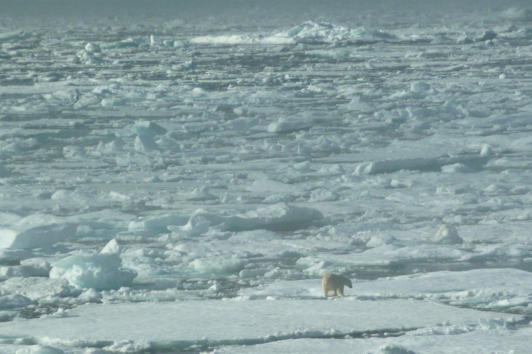
Sea ice gathers at the eastern end of Baffin Island in summer, carried down the Davis Strait by the Labrador Current. It lingers here for a long time, and therefore, so do polar bears. By 7:12 AM today, August 8th, I was up on the bridge taking photos.

I took this photo with the sun behind me. There is still plenty of haze above the water/ice.
This one, through a bridge window, looks more into the sun, with a completely different result.
Why are we up before breakfast? Bears, of course. Here, a swimming bear.
After a few minutes he reached the denser ice and hauled out.
He began to walk away from us, and eventually faded into the haze.
The beginning of this video shows how difficult it can be to pick out a polar bear amongst all the ice, especially with haze.  Also intriguing is how the ice tilts and lifts up and down on the ocean swells. The polar bear is perhaps a quarter down from the top and just a bit left of center. When zooming in I almost lost him more than once, because it was impossible to see the bear on the LCD screen of my point-and-shoot camera. At full zoom I finally locate him and center the image.


This next photo is not of the same bear; it was taken 50 minutes later. This bear is approaching us.
Within five minutes he's considerably closer.
Then he reaches the edge of his comfort zone and pauses, not knowing what we are. My, what big feet you have!
Can you guess which side of the ship the bear is on?
Summoning more courage, this bear draws even closer.
After a few minutes more, he's within a few yards of the bow. He's further away vertically, because of the height of the Explorer, than he is horizontally.
Here's another look, from a slightly different angle. Love those feet.
Eventually, he decided to leave, gradually. He would meander away, then turn and look at us yet again and sniff the air, then meander further away. Look at the long neck ... all the better to swim and to grab seals from their breathing holes.
After this first flurry of polar bears, the spotting scope was deserted for a moment.
Our next discovery this morning was a polar bear lounging on a small chunk of ice. We drifted slowly towards him, but I'll spare you the approach shots.
Nearby, among all the common gulls, was a seldom-seen ivory gull. These birds rarely travel beyond the pack ice; this one is the little guy on the left. This is another case where binoculars are essential to appreciation of what you're seeing.
An Environment Canada ice chart depicts many kinds of information, through colors and by the Egg Code. It includes the percentage of sea surface covered by ice, the age of the ice (first year? multi-year?), the size of the ice, and more.
Before 11:00 another polar bear, intensely curious, swam very close to the ship, keeping an eye on us. In this video, you can see that the bears swim with only their front legs; the hind legs simply trail behind.
 
This bear lost interest in us in stages. As he swam away he would periodically take advantage of an ice floe to pop up and check us out one more time.
I hope you're not tired of polar bear photos yet.  I have hundreds ... but just one more, from the afternoon.
A long-standing tradition on both the Explorer and its predecessor, the Endeavour, is to cut a notch on the bridge railing for each polar bear spotted. The spotter has the privilege of making the cut. If the bear is on a kill, the notch is then colored red. If it's a deceased polar bear, the notch is black.
Our afternoon sailing was taking us towards  Saxe-Coburg Island, off the tip of Cape Mercy. During the journey we had the option of attending Tom Ritchie's talk, Surviving Cold Environments: How Wildlife has adapted to the Polar Regions.
What is the first thing we find during our late-afternoon zodiac cruise at Saxe-Coburg? Yet another polar bear!
Needless to say, he attracts a lot of attention. In this age of digital photography, hundreds of photos may be taken in just a few moments.
The zodiac ride, while enjoyable, was also chilly, so the Lindblad staff motored around to each boat in the glögg zodiac. (Glögg is a Nordic version of mulled wine).
The Viking helmets are a humorous touch, especially because we learned early in the trip that Viking helmets never had horns. Check out the guy in the bow; he has improvised a unicorn helmet. As soon as we all had a cup of glögg in hand our providers zoomed off to the next zodiac.
As we toured the island we met several flocks of black guillemot. Click to enlarge -- the red feet are striking.
Our route included the passage between the two islands of Saxe-Coburg.
Steer clear of the ice.
Then it was time for our shift to return to the Explorer. Here, our inbound zodiacs are accumulating.
Somebody has to go in first, but it's not us.
We'll wait our turn out here, among the ice forms.
We had time to change out of our cold-weather gear before dinner. In the evening the National Geographic video Masters of the Arctic Ice was shown, and then Joan and I began our night's sleep, before tomorrow morning's hike.