Sunday, October 23, 2011

Washington Odyssey: Mount Saint Helens

July 3
We started our first Mount St. Helens day at the nearby Silver Lake Visitors Center. It has a number of good exhibits, of which I took no pictures. The most memorable part of the visit was the local artists' show in one of their rooms. Elisabeth was particularly taken with a painting of Mt. Hood, of which she has many memories, but there was a technical glitch. The credit card reader had been set up in online, rather than offline, mode. Because it was now unconnected (no phone line), there was no way to convince it to process the transaction, despite repeated attempts. The written instructions left for the artist staffing the exhibit this morning were of no help. Digging into our pockets, we four managed to collectively solve this problem by paying cash. Now Elisabeth had the painting, which we would painstakingly pack into the car trunk three times: this day, the day we drove to Mt. Rainier, and the day we drove back to Richland.

Then we continued east towards the mountain. Unless you obtain the necessary permit, you are not allowed climb Mount St. Helens (some people do), so the approaches are limited to the west and east sides. Here's a roadside map that focuses on our approach:
The eastern sections, including the Windy Ridge Viewpoint at the terminus of Forest Road 99, were still closed for snow. Today we would explore areas before the mountain on State Route 504, and dedicate tomorrow to the mountain.

Our first stop after the visitors center was the Forest Learning Center, which is not part of the National Monument, but a cooperative effort of Weyerhaeuser Company, Washington State Department of Transportation and the Rocky Mountain Elk Foundation. Weyerhaeuser has extensive timber holdings in the area, many of which were affected by the blast. We didn't have the time to explore the exhibits, but ate our lunch outdoors and pondered the North Fork of the Toutle River, which was inundated by the ash and mudflows of the volcanic eruption. After 31 years, the vegetation has made a comeback.
Looking east, you can see the stream emerging from the wastelands at the foot of Mount St. Helens.
With binoculars there is a wealth of detail to be seen. Here is zoom photo from the same spot, revealing the extreme sinuosity of the watercourse.
From the center we drove on, past the now-shuttered Coldwater Ridge Visitors Center, to hike the Hummocks Trail. This is an opportunity to walk among the mounds and ravines of mud, stone, and ash and see the varying responses of the flora and fauna, which are returning faster than originally predicted. In places there are tall hummocks ...
where the sides are too steep to resist erosion. There are also partially exposed remnants of the forest that was here before May 18, 1980.
Sometimes the trail takes a turn to frame the mountain.
The water, especially during storms and spring melt, carves and slices the loosely packed terrain, creating slopes, wrinkles, and folds, while the plant life strives to anchor the ground.
Some of the cuts expose the stratigraphy of the flows, and how thin the green layer is.
Harry Glicken earned his doctorate mapping these flows, which resulted from three distinct collapse blocks of Mount St. Helens (click to enlarge, but you still may not be able to read the fine print).
Harry died in a pyroclastic flow at Mount Unzen, Japan, in 1991 that killed 43 people. He would have been killed by the Mount St. Helens eruption, but he was away on an interview; his replacement observer, David Johnston, lost his life instead. Johnston Ridge is named for David.

I'm thinking that life insurance for vulcanologists must be very expensive.

The story of the Hummocks Trail is also one of renewal. Several sheltered pockets of forest have sprung up, for example.
At one location there is a beaver dam and lodge. It must have been an arduous journey for the pioneer beavers, but that's what nature does. It relentlessly explores niches.
Every time we talked with someone and mentioned taking the Hummocks Trail, they asked "Did you see the beaver lodge?"

Dinner this evening was at Patty's Place (now closed), at the 19-mile marker on our road. The fruit cobblers were outstanding, and we resolved to return for tomorrow's supper.

We arrived back at the Blue Heron in time for sunset.
The snows on the mountain picked up the colors of the sky.

July 4
Today was dedicated to Mount St. Helens itself. Our first driving stop was the Loowit Lookout, a scant mile from the Johnston Ridge Observatory. The parking lot was not crowded.
The view towards Mount St. Helens was striking. Of course, everywhere on Johnston Ridge the view would be striking, but slightly different as you continued east. I took several dozens of pictures of the mountain this day.
From the Loowit Lookout, there is a trail that winds down the ridge, and after 3½-4 miles deposits you at the parking area for the Hummocks Trail. The Forest Service describes it hiking in the uphill direction. The next photo looks along the ridge in the downhill direction, although the slope isn't apparent yet.
In the other direction, uphill, you would arrive at the Johnston Ridge Observatory in less than a mile. You can see this trail in the earlier parking lot photo. The Monument has volunteers who help explain and recommend features to visitors, and we met our first one here. She recommended hiking up to the Observatory, but we had a different trail in mind.

We spent two hours at the observatory, taking in its exhibits and a marvelous video presentation which ends with the theater curtains drawing back to reveal the mountain looming in front of you. On cloudy or foggy days it would only be a blank gray wall of glass, but we were, as you can see from these photos, very lucky with the weather. We needed plenty of sunscreen.

The observatory is largely built into the ridge, and in the colors of the ridge. There is no imposing building to take a photo of, rather, it is impressive how well the observatory blends into the landscape. It is in the upper right of this photo.
After exploring the observatory and consuming our brown-bag lunches, we set off on the Boundary Trail, which winds eastward and then turns north around a shoulder of the ridge. The next image is two Google Maps views of the trail stitched together, with red dot "bread crumbs" showing where we went along the trail. You can see the Observatory parking area in the upper left, but for anything else, you'll need to click to enlarge! Mount St. Helens is off the bottom of the map.
 The views of the mountain are continuous along the trail.
We later learned that the trail had been opened up only two days before, again because of lingering snow. The rangers must have waited until every inch of the path was clear!

As we continued to the east, the view into the caldera opened up, and the lava dome appeared, evidence even to the casual observer that the mountain is still alive.
Here is a maximum-zoom photo of the dome.
By cropping severely, I can zoom in further, and if you click on the image to enlarge it, you can see steam rising from the rocks near the center. Through binoculars, the plume reminded me of steam pouring up from a hot teakettle.
After heading east for while, the trail jogs south before coming around a corner and heading north. This is the narrowest part of the path.
At the switchback, both Mt. Adams and Spirit Lake come into view, along with the still-inaccessible Windy Ridge on the far side of the lake.
Zooming in on Mt. Adams, we can also see the straight line of the road on Windy Ridge, with snowbanks.
Where the trail swings back to the north is the closest approach to Mount St. Helens. Here's what it looked like:
Near our turnaround point, we observed a female horned lark, who had been misled -- with the trail closed until two days before, she had chosen to build her nest by the side of the quiet way, but now there were frequent interlopers walking by.
On our return we encountered this fearless chipmunk. He's seen people before.
Back at the observatory we took the brief paved trail to the official observation point, where we met another Monument volunteer and had an engaging conversation. Then, down on the main viewing deck in front of the Observatory entrance,
a ranger gave a brief presentation on the 1980 eruption. A concise timeline of the eruption is available here.

Also on the grounds is a memorial to those who died in the eruption.
On our way back down route 504 we stopped at a parking area to admire the Hoffstadt Creek bridge, the largest of the 14 new bridges built post-eruption.
This spot was at the edge of the blast zone, as described in the Weyerhaeuser sign at the viewpoint.
Then it was time for dinner at Patty's Place, for which we were barely in time; they were closing early for the 4th of July holiday. It had been a long day, but a satisfying one. Afterwards at the Blue Heron we packed for our next day's journey, to Mt. Rainier.

Monday, October 17, 2011

Washington Odyssey: North Cascades and Onwards

July 1
This day we took a long and scenic drive through the North Cascades National Park along the North Cascades Highway (State Route 20), and hiked along the Thunder Creek and Fourth of July trails.

We drove west from the Freestone Inn, and immediately began climbing. After several miles we passed through a hairpin turn and stopped at a pullout.
You can see the snow; the air was bracing and the scene was brilliantly illuminated. We were, it turned out, only a couple of minutes from the Washington Pass Overlook (5638 feet).

View Larger Map

The overlook has a short loop trail with views that beg you to linger, such as this one where, near the center, you can see a part of the hairpin curve. As always, you can click to enlarge the photo.
The trail is paved, and there are handrails in the important spots. Here, even on July 1, there were small areas where a snowbank covered the trail. The parking area had obviously been cleared by plows.
The Rainy Lake trail was at the top of our list, but at 4855 feet, the parking area was still filled with snow, and also the woods beyond. We continued driving the long, straight downhill and arrived at the Diablo Dam overlook, well above Diablo Lake itself, which is 891 feet above sea level. Having lost thousands of feet in altitude, we found the air much warmer and the snow gone. The dam, in the center of the next photo, began generating electricity for Seattle in 1936.
Zooming in on the Thunder Arm, just to the left of the above photo, we see canoeists enjoying the sunshine (click to enlarge).
We drove on to the visitors center for the national park. This spacious center had several engaging audiovisual exhibits, a bookstore/gift-shop, and an stuffed banana slug mascot.
It was also a good spot for our brown-bag lunch! We afterwards walked a nature trail looping from the visitors center, and at the main overlook, an enthusiastic Bostonian offered to take our picture. We couldn't turn him down, even if the lighting was less than ideal. I hope he continued to enjoy the rest of his trip as much as he was enjoying this day.
From left, it is Joan, Ben, Lyn, and Elisabeth.

We drove back a few miles to Diablo Lake and then to the Colonial Creek campground, to begin hiking on the Thunder Creek trail. No, I can't explain the difference in the names. Perhaps Colonial Creek is a tributary of Thunder Creek that enters somewhere near the campground.

The trail, friendly and wide, begins where Thunder Creek is also broad and slow. The creek narrows as we gently rise walking up the valley.
 

View Larger Map
The forest here has an open, unobscured feeling. The generous moisture -- we are on the wet side of the Cascades -- allows the trees to grow on top of rocks.
Many of the trees in the next photo, rooted in graveled soil where the creek floods every spring, appear to have succumbed to some event.
Further on the creek has narrowed, and is still high from the prolonged snowmelt.
At this point the trail crosses the creek.
Shortly after crossing the bridge the trail forks, with the Fourth of July trail (heading up to Fourth of July Pass at 3507 feet) leaving to the left. We decided to climb up towards Fourth of July for a short while before turning around. There were downed trees from the heavy snowfall, and I thought the growth rings and chainsaw ripples on this cross-section worth a picture.
On the way back down to the junction, we were all in favor of a pit stop, inspired by a sign at the beginning of a short spur that said "Pit Toilet". We were unanimous in calling it the best view from a toilet that we had ever seen.
Then we were in fine shape to hike back to the car and take the long drive back to Washington Pass, the Freestone Inn and dinner. 

July 2
This day was a travel day, starting with a hearty breakfast at the Mazama General Store. I took a picture of this beauty in their courtyard.
Then it was time to retrace our drive of yesterday through the Cascades, and more, but we had time to stop for a walk at the Gorge Creek Falls and Gorge Dam, which, along with Ross Dam and Diablo Dam, is part of the Upper Skagit River Hydroelectric Project. As you can see from this Google Maps view, there is both an interesting gorge where the creek joins Gorge Lake, and a parking area for the short hike to view the dam.


View Larger Map

To view the side gorge, you cross the bridge.
You can look straight down as well as sideways, for the bridge and its walkway are made of metal grating.
The best views were still obtained by leaning on the railing and looking out and down.
The walk to view the Gorge Dam was a pleasant leg-stretch, but tree growth narrowed the view.
We had hours yet to go, but leaving the Cascades area we came across the perfect place for a snack, for "elevenses," or more precisely, "twelvsies."
Cookies and ice cream, berries and other good things were welcome; the day was warming up, and steady stream of traffic arrived and departed. From the side, the farm shop exhibited an interesting swayback, almost a Thai architectural note.
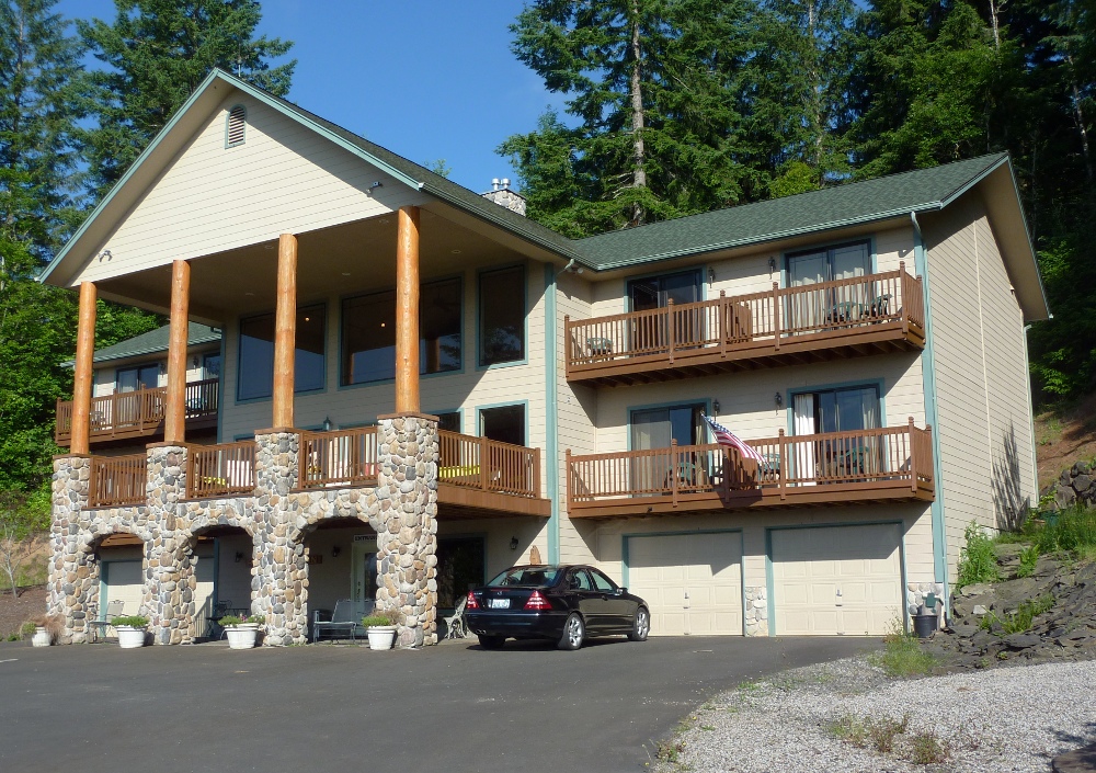
Then it was time to drive on, through Seattle and down to the Blue Heron Chateau, a bed and breakfast (and event center) just a stone's throw from the Mount St. Helens National Volcanic Monument Visitor's Center at Silver Lake. According to Google Maps, today's drive totaled 357 miles.
The ground story, between the garages, is a wine-tasting room run in cooperation with Mt. St. Helens Cellars. The top two stories have guest rooms and spacious common areas.

When we arrived, the manager on duty was overjoyed, for she was anxious about whether the Neely party really existed (Lyn had made the reservations). Two years ago the founder and original owner of the inn had sold it, but the new owner had let it run down and eventually stopped making any payments on it. The original owner went to court to have the property returned, but while the issue was being decided, the new owner milked the situation, abandoning all maintenance yet continuing to take people's deposits up until the day he was evicted. 

The only evidence that a party of four named Neely had booked two rooms for the Fourth of July weekend was a single line scribbled in pencil in a random notebook page. There was no address, no phone number, no contact information whatsoever recorded for the elusive Neely. The original owner, reviewing the ghastly situation after retaking possession, considered dropping this most mysterious reservation of many mysterious reservations, but the manager decided to retain it. What if a family of four showed up on the Fourth of July weekend and were told they had no rooms? Still, the thought of having two empty rooms on the long holiday weekend was worrisome. When we walked in, excitement reigned and the owner was phoned to let her know that the Neelys had arrived!

Because the deposit had been sent to the delinquent ex-owner, it didn't exist for the current and restored owner. We would have to pay the entire amount, and Lyn would need to recover her deposit from the ex-owner, who had a lawyer who was handling reimbursements. There was a form detailing what information to mail to the lawyer.

We felt fortunate to have our rooms, and the reinstated staff had done a great job on short notice to repair or paint over the damage and neglect of the ex-owner. (Repossession had happened only two months before.) We were happy with our rooms, and with the extensive hot breakfast feasts at a long community table. And the fresh cookies each afternoon.

The famous volcano and object of our stop here, Mount Saint Helens, is visible from the inn. It's about 46 miles away by car, slightly less as the crow flies.
The mountain presents itself well through binoculars; here is a zoom photo.
Our next two days would be spent exploring the Mount St. Helens National Volcanic Monument, and, in a spoiler, I'll tell you that the weather co-operated.