Sunday, January 24, 2021

Great Seal State Park (Part 3)

In October and November of 2020 Joan and I made four trips to Great Seal State Park, to hike and thus explore this park for the first time, getting outdoors during the pandemic. This post is part three of three about Great Seal, covering the fourth hike, on November 20th. Part one of the series is here, and part two is here.

The park is named "Great Seal" because the hills of the park are a feature of the State Seal of Ohio. They are part of the view from Adena Mansion, the home of Thomas Worthington, Ohio's sixth governor.

Here is an overall map of the trail systems, which curl around and up and down the terrain. Click on the image to enlarge. As you can see from the map, the park is much taller, north-to-south, than wide.

Many of the trails are multi-purpose, with foot, horse, and off-road bicycle traffic allowed. In addition, there is a spider-web of narrow bike trails that are unsuitable for horses and lack the signage of the multi-purpose routes.

Joan and I drove to the southernmost parking area, off Lick Run, where we'd parked twice before.

There is a bench here dedicated to Annie Rooney, the guiding light and spark plug for the creation of the bike trails here; she was killed by a drunk driver in 2013.
The parking area is at location V on this map. We began by taking the Lick Run trail to intersection M, then up the Mt. Ives trail to W. (Click on the image to enlarge.)

On this day we spotted a great many pear-shaped puffball mushrooms, Lycoperdon pyriforme or, since 2017, Apioperdon.

Joan enjoys assisting their spore dispersal, as you can see in this short video.


 At W, another Annie Rooney bench.

As we continued on to intersection N Joan spotted some crane-fly orchid (Tipularia discolor) leaves, easily identified by their green upper surface and purple underside. A single leaf emerges in September and disappears in the spring, the opposite of what you'd expect.
When we reached Y, at a park boundary, we encountered this sign.
Unexploded ammunition? It likely rocketed here from Camp Sherman, now the National Guard Camp Sherman Training Center. Camp Sherman was hastily erected in 1917, just a mile or less away,
when the United States entered the First World War. By the time it was decommissioned in 1921, over 120,000 men had passed through for training -- including the 324th Field Artillery. We were not tempted to enter the forbidden zone. Instead, Joan and I looped around to intersection P, and visited the Bunker Hill ridge top again.
A panoramic view from the swing bench at the tip of the ridge.
Since our last visit to this spot someone had installed some solar powered lights.
I wonder what it looked like at night from the houses below.

Joan and I continued clockwise on the outer loop, the section of Bunker Hill we hadn't walked through before. Wavy trees stood like kelp in salt water.

Not all were still upright.
We also passed an old stone structure, long disused.
The trail lost altitude, and with the leaves fallen from the trees, we could see that were were close to some houses at the edge of the park.

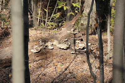
More fungi along the way.

Joan and I continued through point Q and towards R,

and we reached a surprise, a "Trail Pod" with a McLeod tool and a sign. (Click on the image to enlarge.)
Volunteers can scan the QR codes to sign in, review the trail guidelines, use the McLeod to improve the trail, and sign back out. This was designed for individual effort, given that there was only one tool. Intriguing!

We dropped down to the trail next to the road on what might have been a bike trail, or just a well-trodden shortcut. (It was an unmarked, unexpected intersection). Then heading north we crossed the road at intersection J and continued through S and then K to reach the Bonus Hill trail.

At the right spot for the intersection, which has no designation, we saw just a small sign on a tree, as if for a bike trail, and the name was not "Bonus Hill." However, it being in the anticipated location, we took it. The trail curved and turned and crossed the Rocky Knob trail, which we took to L. To finish our return we headed right on the Mt. Ives trail, aiming to cross the road to hit M. But partway back -- well past the unmarked green trail departure to the right --  the trail forked and confused us. Which was the true path and which was an unmarked alternate, another pesky bike path? We went partway on the straight-ahead fork, then returned to take the left fork, then gave up on that when we saw a huge tree trunk across the trail, retraced our steps and regained the straight fork. Of course, that turned out to be wrong choice, a bike trail, which wiggled and wound until it hit the Lick Run trail, which we descended to cross the road directly across from the parking area. You can't get lost in Great Seal, but you can easily take the longer way when coping with unmarked intersections!

Great Seal State Park has been a great find, and it will be fun to visit it in different seasons. (One advantage of winter workdays is the scarcity of other visitors.)

Sunday, January 17, 2021

Great Seal State Park (Part 2)

In October and November of 2020 Joan and I made four trips to Great Seal State Park, to hike and thus explore this park for the first time, getting outdoors during the pandemic. This post is part two of three about Great Seal, covering the third hike, on November 13th. Part one of the series is here.

The park is named "Great Seal" because the hills of the park are a feature of the State Seal of Ohio. They are part of the view from Adena Mansion, the home of Thomas Worthington, Ohio's sixth governor.

Here is an overall map of the trail systems, which curl around and up and down the terrain. Click on the image to enlarge. As you can see from the map, the park is much taller, north-to-south, than wide.

Many of the trails are multi-purpose, with foot, horse, and off-road bicycle traffic allowed. In addition, there is a spider-web of narrow bike trails that are unsuitable for horses and lack the signage of the multi-purpose routes.

For our third visit Joan and I parked not off Lick Run road, our starting point for the first two hikes, but at the campground area at the northern end of the park. We started out on the Shawnee trail, in blue, at the top of this map.

Note how Shawnee skirts the Disc Golf trail.

Our first goal was Sugarloaf Mountain, so at intersection A in the above map we turned left, onto the yellow route, only to descend before the steep climb up Sugarloaf. It's one of the steepest sections in the whole park, straight up the side and gaining 500' in a quarter mile. Joan and I were glad we brought hiking poles; I'd hate to go down that trail in wet weather.

Gaining the top.
Looking to the west.
Then it was down the far side, passing stately trees.
The trail plunged down Sugarloaf to intersection B, and then wound towards the base of Bald Hill before climbing again.
Joan and I continued to intersection C,
and then took the left-hand path to visit the ridge of Bald Mountain. The climb wasn't at all bad, not like Sugarloaf.
A hornet nest seen along the way.
Hikers and bikers had been on the ridge before us.
The descent from the ridge line to intersection E, a gap between hills, was steep at first, but we managed to stay upright. Just before reaching E we saw the skeleton of an old car off to the left, a reminder that this land was not pristine when it was incorporated into a park. Not long after engaging with the switchbacks up to Sand Hill, there was another reminder. (Click on the image to enlarge.)
Another visit to Sand Hill, an excellent snack stop.
More photos at Sand Hill, from the previous hike's visit, are here. From Sand Hill we continued south to the closed road.
Joan and I were curious to see why the road was closed, walked around the barriers, and headed downhill. The answer was soon obvious.
The road had been eaten away for the next half mile. Joan suggested that an early farm road, meant for wagons and such, had been paved over without proper consideration of the heavy loads that would then traverse it. The soils underneath couldn't support them indefinitely.

On the road we reached the point where the Grouse Rock trail passes close by, also near the middle parking area, near the top of this map.

A short connector from the road to Grouse Rock exists and is signed, although it doesn't appear on the map. We headed east, rejoined the Shawnee trail, and began our return. Joan and I chose to take the Sand Hill trail between H and G, avoiding the steep descent on Shawnee after H.
We hiked down the pleasant switchbacks to E, and turned left to intercept the Shawnee again, passing just below the Bald Hill ridge.
Joan and I continued on Shawnee, retracing our steps of the morning, except between B and A, the segment not taken on the way out because of our Sugarloaf excursion.

We could not see what was special about this tree or location, but it caught our eye.

We heard voices on our return; the disc golf course had players taking advantage of the sunny afternoon. The course does pass through the woods, so it must be a challenging one. Joan and I passed close enough to the players to glance at them, but we didn't speak; the Shawnee and Disc Golf trails come close but do not intersect.
This day covered a lot of ground!

Thursday, January 14, 2021

Great Seal State Park (Part 1)

In October and November of 2020 Joan and I made four trips to Great Seal State Park, to hike and thus explore this park for the first time, getting outdoors during the pandemic. This post is the first of three, covering the first two hikes.

The park is named "Great Seal" because the hills of the park are a feature of the State Seal of Ohio. They are part of the view from Adena Mansion, the home of Thomas Worthington, Ohio's sixth governor.

Here is an overall map of the trail systems, which curl around and up and down the terrain. Click on the image to enlarge. As you can see from the map, the park is much taller, north-to-south, than wide.
Many of the trails are multi-purpose, with foot, horse, and off-road bicycle traffic allowed. In addition, there is a spider-web of narrow bike trails that are unsuitable for horses and lack the signage of the multi-purpose routes.

October 28
For our first visit Joan and I parked at the southernmost access point, off Lick Run road.

We set off to the right, to begin our exploration with Bunker Hill. The trail signs are maps, each covering a relevant section. This sign shows our starting point today (point "V"), although I actually took the photo at point "I" on our second hike.
Being novices here, we were confused by a bike trail, marked with a small wooden sign nailed to a tree and bearing only a name, and took that route
until it crossed the regular trail again and we recognized where we were.

We quickly noticed that while many of the trees had shed their leaves (sometimes obscuring the lesser trails), the pawpaws were still golden or even green. They will never grow tall enough to form a canopy, preferring the partial shade of other trees, and tend to grow in groves. They reach six to eight feet tall in Great Seal; with a bit more light in our back yard, our two pawpaws are easily twice that. My only photos, however, are of distant or young, short ones:

It's been a wet year, and fungi were common. These were imitating a pair of white gloves.

The Bunker Hill trail, shown in green on the trail sign, has a lower loop around the hill, and from that rises a loop up to and around the ridge top. At the end of the ridge we were not surprised to find a good viewing spot, but Joan and I did not expect a table, chairs, swing, and, on the table, a weather vane.

This was a great place to pause and have a snack. Then Joan and I pushed on, working our way towards the Mt. Ives trails. I should have taken more photos; we were frequently consulting our paper maps and cross-checking them with the trail signs. We passed more than one bike route, and may have been on one for a while reaching the top of Mt. Ives, at or near point"X."

Then we descended to point "W," where there was a long stretch of barbed wire -- note that W is at a park boundary. White plastic flags were attached to the barbed wire every so often to warn the barnstorming bikers. There was also a bench dedicated to Annie Rooney, the guiding light and spark plug for the creation of the bike trails here; she was killed by a drunk driver in 2013.

I don't know why it says '2100'

Across from the bench there was a "bicycle Jesus."

From there it was downhill to point M, and we decided to cross the road and explore the Rocky Knob trail. This route ascends a watershed, but above it along the west side. The trail wiggled because each time it encountered a tributary ravine it would swing away from the main watershed until the obstacle was shallow enough to cross, and then return. Joan and I didn't find a particular knob on the Rocky Knob Trail, but the route was unknown to us and hence intriguing; all sights were new, and we met a congenial mountain biker. Unfortunately I didn't take any photos!

November 4
On our second visit we parked in the same spot, but crossed the road and took two loops on the way north, Annie's Trail and the Rock Garden Loop. The trail early on:

Rock outcrops began to appear.

At the intersection with the Annie's Trail loop.
After Annie's Trail, we picked up the Rock Garden Loop (sorry, no photos) and continued north to intersection I.
Continuing beyod "I," Joan and I came to an obvious high point: two transmitter towers.
As you can see, branches and trunks had fallen on the chain-link fence surrounding the installation. Maintenance is apparently not a high priority.

Beyond the towers was a short descent and the Rocky Road crossing; the way is open to the east but closed to the west.

Joan and I continued north to "H."

There we plunged downhill on Shawnee towards F.

Just before the steep drop.

 Looking back the way we had come.

We stayed on the Shawnee as it cut back and forth, and passed through D, aiming for the un-lettered black trail that takes off from the right -- can you see why we kept checking our map? We encountered two equestrians coming the other way, one riding a horse and one a mule. I had never seen a mule up close before; it was more horse-like than I expected, a bit smaller but of a very different temperament. The horse was quite placid and content to wait while we talked, but the mule was impatient. The riders were looking for the trail to Bald Hill. Not having found it yet ourselves, we couldn't help them. They continued on. In retrospect, to follow the ridge line, they should have picked up the black trail back at C. We soon found the side trail, though not in time to run back and inform the riders. Our trail, we discovered, stayed on the flank of the hill, not the crest, and gained little altitude. The top of Bald Hill would have to wait for another day.

Joan and I passed through E, at a gap in the hills, and then G, to reach Sand Hill, the highest point in the park at 1,296 feet. The numerous switchbacks on the north side made the climb from E an easy if lengthy tromp. We decided to pause here, three hours plus after setting out.
Old foundations still lay near the apex.
A panoramic view.
Other visitors had left a cairn. It seems unnecessary ...
A golden tree and blue sky.
A steep but rapid descent took us back to Rocky Road, and then the antennas. More fungi were along the route.
When we reached intersection I, rather than return the way we came, Joan and I took the Grouse Run Trail, which at one point swings close to the other side of the closed road. There we encountered our equestrians again, and had a pleasant chat, although the mule was watching us closely and would toss his head, eager to move on.

We crossed Lick Road Run at J, and returned to the parking area after a long but rewarding day. Joan and I would be back, for there were still plenty of trails to explore.