Showing posts with label morning glory lakes. Show all posts

Tuesday, January 20, 2015

CR2014: Big Larches and Odaray Grandview

On July 23rd Joan and I decided to hike to Lake McArthur by our favorite route, the Big Larches Trail. We find this trail more scenic than the eroded, switchbacked trail that leaves from the Elizabeth Parker Hut. To help you follow today's meanderings, here is a map courtesy of Parks Canada (click to enlarge).

The Big Larches trail emerges from the woods surrounding Lake O'Hara and Mary Lake and skirts the edge of a vast rockfall, where it begins to climb.
Eventually it turns to the right and dives deeper into the larches for which the trail is named.
We passed the trail to All Souls Prospect on our left, then soon, at the outlet from Schäffer Lake, merged with the trail arriving from the Elizabeth Parker Hut. From here, Joan and I took the route to Lake McArthur that passes near the sign-in for the Odaray Highline Trail, established for the benefit of wildlife passing through the choke point of McArthur Pass. To quote Parks Canada,
Adjacent to McArthur Valley and contributing to the corridor is the Odaray Plateau. Habitat here is used seasonally by several species, including grizzly bears and mountain goats. The plateau is closed in summer to protect habitat and to limit disturbance in the wildlife corridor.
The Odaray Highline Trail cuts across the pass, skirting the closed zone. There is a voluntary program to limit the number of groups that use this trail; when we were there, the check-in station requested no more than four groups per day until August 15th, and no more than two after that. This makes grabbing an Odaray Grandview slot difficult, because hikers in the campground can get started earlier then hikers from the lodge. Note: this Parks Canada web page, updated September 2nd, 2014, now requests only two groups until August 15th, and zero after that.

Because the program is only voluntary, we've seen lots of people violating it, but we do not. The bears were here first. This means that we haven't been able to visit Odaray Grandview for several years. (Many wonder at the efficacy of a voluntary program: how much does it really accomplish?)

This year we were lucky. After passing the guard marmot
we checked the sign-in book, and there was an open slot for us! Lake McArthur could wait for another day.

Wanting to do the right thing, we waited to see if any other hikers wishing to take the Highline would show up. We could form a single group, you see, and all could go. And not long afterwards, a group of two moms and four kids arrived.
They decided they would join us. The Highline, after crossing the pass, makes a right turn, wanders through some rocks, and then begins a gentle climb on the lower slopes of Odaray. The view begins to open up.
Then the trail arrives at the point where the Odaray Plateau is closed. The only way to go is up, to the Grandview, on a steep trail that occasionally demands a handhold. However, it's not exceptionally long, and the view at the top is rewarding. Joan and I pulled ahead of the family group, but for some reason I didn't take any photos until we got to the top.

There, the view is a jaw-dropper.
The valley on the left holds the fire road down to the TransCanada Highway. In the middle is Lake O'Hara, surrounded by peaks. A bit further right is Schäffer Lake and a meadow. Visible at far right, in its bowl, is Lake McArthur. Zooming in, my camera can even pick out hikers atop All Souls Prospect!
There are plenty of loose stones of all sizes on the Grandview's bench. Rock piles created by hikers and climbers have gone far beyond simple cairns in the last decade.
Joan provides scale for this stone windbreak, useful for staying warm and keeping sandwiches in hand when winds come howling up the pass.
We ate our lunch up here, and never saw the family group. On our way back along the bench, before the trail starts seriously descending, we saw them arriving at the descent point from the other direction along the bench. Hmm. We had never been over to the other side. Perhaps something was there?

Yes indeed, a spectacular look into the Duchesnay Basin. How could we have overlooked this?!
In the foreground, there's the best view of the Morning Glory Lakes that I've ever had. Beyond a rise, you can see much of Linda Lakes. On the far side of the basin rises Cathedral Mountain, and below it the mixed rock faces and trees of the Cathedral Prospect, which we've hiked before.

On our return descent we caught up to the family group, and we all stopped for a snack. Then we spotted ptarmigans, at least one parent,
and one chick.
We continued retracing our steps to our cabin, and enjoyed another fine dinner at the lodge. On an evening lakeside stroll, I took several photos of the Sufi Bench,
which I've discussed in detail at the end of this post. My photos of the bench allow Bob to keep an eye on its condition.


Saturday, February 22, 2014

CR2013: Last Larch Prospect

Today's plan is to hike to Last Larch Prospect, which we had not done since 2009. The first portion of this trip visits Linda Lake and Cathedral Lakes, which we have hiked to several times, most recently in 2011 and in 2012. Given the distance to Last Larch Prospect, we opted to hitch a ride on the morning lodge bus as far as the Linda Lake trail, which saves a couple of uninteresting kilometers on the way out.

Here we see the Parks Canada bus, not the lodge bus, but the photo illustrates the early post-breakfast light.
Looking in the other direction, towards Wiwaxy Peaks, there's a wonderful reflection.

This map section shows the Linda Lake trail near center top. Just remember to tell the bus driver that you want a drop-off there!

Less than half an hour after leaving the bus Joan and I crossed a footbridge, and every time I see this view, I am compelled to take a photo.
Here's a closer look at Odaray Mountain.
As you can see from the above map, after passing the Four Way Junction you soon arrive at the northeastern end of Linda Lake. Let's pull in another section of the map, covering the ground between Linda Lake and Last Larch Prospect.
We wind around the far side of Linda Lake and continue on the Duchesnay Basin trail, walking through a mixture of meadow and woods.
The trail crosses a footbridge at the head of Cathedral Lakes.
After a couple of meadows and woods the trail splits, ahead for Duchesnay Basin and right for Cathedral Basin/Prospect.
Joan and I head straight, and shortly thereafter we arrive at a long meadow. Here it is in 2013 ... an easy stroll ...
and here it was when we first visited in 2009. The guidebook claimed it was almost always dry, but it wasn't back then! This year we didn't have to bash along the shoreline.
The trail gradually climbs, with an occasional short but steep pitch over a hillock or moraine.
The last section is all uphill; this view is looking back.
The cairn in the center of this photo kept us on track until it was time to climb the slight ridge on the left. We're almost there!
The prospect is marked by a black-and-white striped pole. We ate our lunches here, and I discovered that I had picked up the wrong lunch bag part-way through the self-serve lunch-fixings line. Fortunately my sack had the famous Lake O'Hara cookies that I'd picked out, the most important part of the meal.

This video scans from the prospect, taking in the passes and peaks lining the Duchesnay Basin, plus the view back towards Lake O'Hara. At the end it zooms in on the black-and-white pole.

Joan and I decided to repeat our adventurous return route from 2009. Rather than retrace our steps, we headed further out and down to the left, in order to cross the creek at the foot of the mountains while it was still small. This off-trail option was described to us by Bruce, at Lake O'Hara lodge, back in 2009 as a possibility if time and energy permitted.

Here's our farewell glimpse of Last Larch Prospect.
As soon as we left the heights the land was cut by gullies curving down towards the creek. We picked one -- further up the basin than in 2009, when we had difficulty crossing the creek with dry feet -- and began working our way downhill. The sides of the gully rose.
We switched from side to side of the gully, sometimes abandoning one gully for another, through low spots. Lower down we also maneuvered along stream banks. Here is a photo from 2009.
We arrived at Duchesnay Creek and crossed it. After following the stream for a while I looked back towards the head of the basin.
This initial stretch, labelled Odaray Lakes Flat, is fine for walking, but the other side of the creek is choked with brush and mud. After we reached the Odaray Lakes the margin between the mountain's edge and the water disappeared. We were to begin rock-hopping.
For a while we could still follow Duchesnay Creek. 
The best way forward was to hop from rock to rock; otherwise you are smashing through dense woods or climbing the mountain's flanks. Sometimes the rocks are flat and cooperative, but most often you must calculate a path of small leaps on rocks of many shapes: ridges, indented tops, flat surfaces sloping the wrong way. Losing your footing could mean a nasty sprain or worse, miles from the road, so progress was slow. 

After the creek veered away we were left to traverse the Rutherford Moraines. Here is one section. More rocks.
After the first hundred meters rock-hopping became tiresome, for the feet as well as the mind. This route wasn't as exciting the second time around, somehow, and it seemed to go on forever. With each new turn hope rose in my heart that it would reveal Linda Lake, but it failed to do so time after time. When would the lake show up?

Finally Linda Lake appeared on the left, reachable by a short downhill stretch blissfully free of rocks. We were back on a trail! Linda Lake, beautiful as ever, demanded a pause.
The walk back to Lake O'Hara lay ahead of us. First, switchbacks down the Linda Lake Beeline trail, reaching the Morning Glory Lakes. Then, regaining the lost altitude on the Lower Morning Glory trail, with a couple of last opportunities to scan for marmots and pikas in modest rockfalls, followed by a 120º turn and a long trudge through the viewless woods, which we had avoided in the morning with the bus drop-off. If hiking earlier in the year there is the possibility of at least hearing hermit or varied thrushes, but not today (September 4th). Joan and I felt great relief when we reached the Alpine Meadow pond and Elizabeth Parker Hut. Almost done!
Our cabin was a welcome sight. We were both footsore, and while glad to have visited the Last Larch Prospect again,  we find the off-trail return to Linda Lake has lost its charm. We are unlikely to repeat it.

Saturday, September 1, 2012

CR2012: Morning Glory, Linda, and Cathedral Lakes

Our training goal for the next day, compared to the preceding days, was a longer hike with fewer steep sections. We decided on going to Linda and Cathedral Lakes, but, because we were not going as far as Monica Lake, which we did the previous year, we started the hike from our cabin instead of taking the bus to the Linda Lake junction.

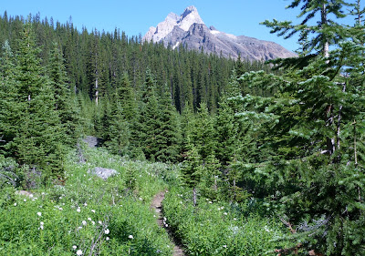
The first trail segment is called the Morning Glory Lakes trail, and it winds for a long, long time (especially on the return) through the forest on the outskirts of Odaray Mountain.
After a while the path goes around a shoulder and begins to descend to the Morning Glory Lakes. Here is a picture taken as we drew closer to the middle lake.
We continued down and around the left side of the lake, encountering a rich grove of flowers in that sunny, moist environment.
The trail was briefly in the open. Cathedral Mountain ruled the horizon.
We soon faced a choice between the Linda Lakes Beeline trail, which switchbacks directly over the moraine in the photo above, and a more circuitous route via the Morning Glory Valley.
We intended to resolve a mystery, so we knew we were taking the Morning Glory Valley connector. There is a Linda Lake Circuit, a way to circumambulate the lake. This explanation may be clearer if I first provide a map:
The link on the east side of the lake, connecting the northern and southern arms of the Linda Lake trail, had apparently disappeared in our earlier visits. We felt this way because the trail sign where the southern arm and the eastern link should join points only down the southern arm, and a log or two crosses the unlabeled, faint link trail heading north, as if that path is considered 'discontinued.' But we thought we had seen a different indication, last year, at the sign at the junction of the eastern link and the northern arm. We were going to revisit that spot and take any trail south, no matter how tenuous, to discover what now existed.

Arriving at the northeast junction, we inspected this sign. It shows the Linda Lake Circuit heading both west and south.
We headed south. On that narrow trail we had to brush past tree limbs a few times.
We were definitely making our way down the east side of a lake.
As you can see from Google Maps, the main body of Linda Lake is connected to this long, skinny arm.

View Larger Map

We paused at a good place for a rest stop. I found the clarity, aquamarine color, and hypnotic waves of the lake here worth a short video.

Clarity, Color, and Waves on the East Side of the Linda Lake Circuit from Ben Branch on Vimeo.

The arm of the lake then disappeared, except for perhaps in wetter seasons. We walked through a flowered meadow, and soon arrived at the trail sign for the southeast corner of the circuit.
As you can see, the sign indicates only a passage to the west on the Linda Lake Circuit, with no mention of the east link. A log still blocked the lightly-traveled link. We had resolved the question of whether the east link still existed -- it does -- but not the question of why it seems to have been wiped off the books at this intersection.

After a short walk to the west, we arrived at the shores of Linda Lake. This point gives a wide view of the main body of the lake.
As we made our way along the south shore, I saw this patch of moss, a sapling, and a paintbrush just offshore, and something in its existence in an environment of rock and water appealed to me. It's almost an aquatic bonsai.
The trail passes near the edge of the lake, which can make the ground soft, and then starts to climb a small, rocky moraine. The view of Linda Lake from its southwest corner is one of the best you can get without climbing a mountain.
The structure of the rock pile here -- not too large, not too small -- makes it a favorite of pikas.
We decided to lunch here, and saw a wonderful floor show, including this golden-mantled ground squirrel. He has stuffed his cheeks to overflowing.
Our pika friend stayed busy harvesting as well.
OK, one more pika picture. When they emit their clear, carrying, high-pitched "eeeeep!", they put their whole body into it:
After lunch we marched on, taking the Cathedral Lakes trail, which continues up the Duchesnay Basin.
We paused at the outflow of the largest of the Cathedral Lakes; I took this picture on a footbridge over Duchesnay Creek.
Then it was time to turn around and begin the long walk back to Lake O'Hara. At the moraine where we had eaten, this time there was a pair of hoary marmots to greet us.
The previous winter's deposits were melting in the late July sun, and pouring off Odaray Mountain/Glacier.
Then it was time for the long slog back along the Morning Glory Trail. It was good training; our feet were sore by the time we reached our cabin, but we had been privileged to see gorgeous lakes, flowers, and animals today, under perfect skies.