Showing posts with label last larch prospect. Show all posts

Saturday, January 14, 2023

Back to Canada: Last Larch and a Slanted Bridge

 It's been a while since I posted: things have been in the way. Travel, house maintenance, and other projects. But now, let's pick up again with our July 18, 2022, hike at Lake O'Hara. To set the scene: spring had arrived late this year, so maintenance was behind on repairing the winter's damage.

Joan and I decided to tackle the Last Larch Prospect, which we last hiked in 2013. A message on the lodge chalkboard told us that a bridge on our route had yet to be fixed, but we were unfazed. To make the mileage less daunting, we hitched a ride on the morning lodge bus to the Linda Lake dropoff. (Click on the image to enlarge.)
The yellow circle marks the spot.
Another couple, Sarah and Ross, also took advantage of the dropoff; we would leapfrog each other for the next several miles. Early on, we saw trail damage (primarily downed trees) that still needed to be cleared. All the creeks and outlets, such as this one from Linda Lake, were full and onrushing.
Linda Lake from the north shore. A single photo can't cover the whole lake.
We tromped down the west side to the southwest corner.
That rock pile is a great lunch spot.
Marmots and pikas consider the rock pile prime habitat.
The trail to Cathedral Mountain leaves from here, winding gently through woods and open, grassy areas. At the right time of the season -- not now -- the meadows are an fantastic wildflower quilt.
Nearing Cathedral Lake.
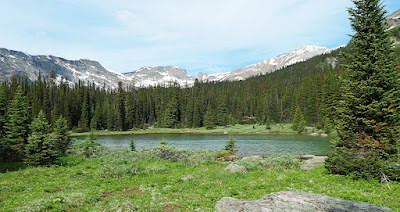
The bridge across the outlet stream was there, but part of it was akimbo.
This bridge is a choke point for heading further up the valley.
The bridge is at the yellow circle.
Joan and I were perplexed, trying to evaluate our options. Then Susan and Ross appeared and demonstrated two ways to cross the bridge.
Joan and I opted for Susan's approach, bumping a few inches along with each flex of the arms. The bridge's angle feels much steeper than it looks!
We caught up to the pair at the trail split, the magenta circle in the prior map. They opted to climb to the Cathedral Prospect, a "regular" trail, while Joan and I headed up the Duchesnay Basin on an unmaintained track.
In 2013 the above pond was dry, but not this July. A duck took advantage.
The trail grew sketchier and sketchier. In 2013, the route up this draw had been clear.
Now the creek bed was filled with fallen trees. More than once we were forced to cast about for route hints. It was slow, tiring work, but Joan and I made it to the last pond before the final uphill push. Stacked rings of pollen had collected on the rocks as the pond dried.
We snacked and debated how much further to go. Dark clouds were piling up, and it was hours of hiking to get back to our cabin, so we decided to eat part of our lunch and turn around. Brief showers peppered the journey back to Linda Lake; they had us donning and doffing our rain gear. Without the need for route finding, our hike back to the slanty bridge went quickly. The angled portion seemed much longer the second time!
Joan and I stopped at Linda Lake's south-end rock pile to snack again, keep an eye out for critters, and enjoy the view.
I admired the color transitions as the water deepened.
We spotted four marmots -- mom, two kits, and pa taking a break further away. Here's one of 'em.
As we left Linda Lake, we encountered our first hikers since leaving Susan and Ross. Then, Joan and I descended an interminable series of downhill switchbacks on the Beeline trail to the Morning Glory Lakes. From there we could see meltwater falling off the mountains.
Next? Regaining the altitude on the other side, and a foot-numbing slog on the Lower Morning Glory trail. Once a fallen tree forced us to doff our backpacks and crawl underneath it to continue. The best parts were hearing varied thrushes several times, chatting with an O'Hara newbie, and the rain staying in suspension. When we reached the Elizabeth Parker Alpine Hut and its pond,
we rejoiced at being almost home. Just enough time remained to clean up before dinner! A tiring day, but instructive and brimming with surprises.

Saturday, February 22, 2014

CR2013: Last Larch Prospect

Today's plan is to hike to Last Larch Prospect, which we had not done since 2009. The first portion of this trip visits Linda Lake and Cathedral Lakes, which we have hiked to several times, most recently in 2011 and in 2012. Given the distance to Last Larch Prospect, we opted to hitch a ride on the morning lodge bus as far as the Linda Lake trail, which saves a couple of uninteresting kilometers on the way out.

Here we see the Parks Canada bus, not the lodge bus, but the photo illustrates the early post-breakfast light.
Looking in the other direction, towards Wiwaxy Peaks, there's a wonderful reflection.

This map section shows the Linda Lake trail near center top. Just remember to tell the bus driver that you want a drop-off there!

Less than half an hour after leaving the bus Joan and I crossed a footbridge, and every time I see this view, I am compelled to take a photo.
Here's a closer look at Odaray Mountain.
As you can see from the above map, after passing the Four Way Junction you soon arrive at the northeastern end of Linda Lake. Let's pull in another section of the map, covering the ground between Linda Lake and Last Larch Prospect.
We wind around the far side of Linda Lake and continue on the Duchesnay Basin trail, walking through a mixture of meadow and woods.
The trail crosses a footbridge at the head of Cathedral Lakes.
After a couple of meadows and woods the trail splits, ahead for Duchesnay Basin and right for Cathedral Basin/Prospect.
Joan and I head straight, and shortly thereafter we arrive at a long meadow. Here it is in 2013 ... an easy stroll ...
and here it was when we first visited in 2009. The guidebook claimed it was almost always dry, but it wasn't back then! This year we didn't have to bash along the shoreline.
The trail gradually climbs, with an occasional short but steep pitch over a hillock or moraine.
The last section is all uphill; this view is looking back.
The cairn in the center of this photo kept us on track until it was time to climb the slight ridge on the left. We're almost there!
The prospect is marked by a black-and-white striped pole. We ate our lunches here, and I discovered that I had picked up the wrong lunch bag part-way through the self-serve lunch-fixings line. Fortunately my sack had the famous Lake O'Hara cookies that I'd picked out, the most important part of the meal.

This video scans from the prospect, taking in the passes and peaks lining the Duchesnay Basin, plus the view back towards Lake O'Hara. At the end it zooms in on the black-and-white pole.

Joan and I decided to repeat our adventurous return route from 2009. Rather than retrace our steps, we headed further out and down to the left, in order to cross the creek at the foot of the mountains while it was still small. This off-trail option was described to us by Bruce, at Lake O'Hara lodge, back in 2009 as a possibility if time and energy permitted.

Here's our farewell glimpse of Last Larch Prospect.
As soon as we left the heights the land was cut by gullies curving down towards the creek. We picked one -- further up the basin than in 2009, when we had difficulty crossing the creek with dry feet -- and began working our way downhill. The sides of the gully rose.
We switched from side to side of the gully, sometimes abandoning one gully for another, through low spots. Lower down we also maneuvered along stream banks. Here is a photo from 2009.
We arrived at Duchesnay Creek and crossed it. After following the stream for a while I looked back towards the head of the basin.
This initial stretch, labelled Odaray Lakes Flat, is fine for walking, but the other side of the creek is choked with brush and mud. After we reached the Odaray Lakes the margin between the mountain's edge and the water disappeared. We were to begin rock-hopping.
For a while we could still follow Duchesnay Creek. 
The best way forward was to hop from rock to rock; otherwise you are smashing through dense woods or climbing the mountain's flanks. Sometimes the rocks are flat and cooperative, but most often you must calculate a path of small leaps on rocks of many shapes: ridges, indented tops, flat surfaces sloping the wrong way. Losing your footing could mean a nasty sprain or worse, miles from the road, so progress was slow. 

After the creek veered away we were left to traverse the Rutherford Moraines. Here is one section. More rocks.
After the first hundred meters rock-hopping became tiresome, for the feet as well as the mind. This route wasn't as exciting the second time around, somehow, and it seemed to go on forever. With each new turn hope rose in my heart that it would reveal Linda Lake, but it failed to do so time after time. When would the lake show up?

Finally Linda Lake appeared on the left, reachable by a short downhill stretch blissfully free of rocks. We were back on a trail! Linda Lake, beautiful as ever, demanded a pause.
The walk back to Lake O'Hara lay ahead of us. First, switchbacks down the Linda Lake Beeline trail, reaching the Morning Glory Lakes. Then, regaining the lost altitude on the Lower Morning Glory trail, with a couple of last opportunities to scan for marmots and pikas in modest rockfalls, followed by a 120º turn and a long trudge through the viewless woods, which we had avoided in the morning with the bus drop-off. If hiking earlier in the year there is the possibility of at least hearing hermit or varied thrushes, but not today (September 4th). Joan and I felt great relief when we reached the Alpine Meadow pond and Elizabeth Parker Hut. Almost done!
Our cabin was a welcome sight. We were both footsore, and while glad to have visited the Last Larch Prospect again,  we find the off-trail return to Linda Lake has lost its charm. We are unlikely to repeat it.