Showing posts with label american dipper. Show all posts

Saturday, December 29, 2018

On the 9th day of hiking (Opabin Plateau)

September 14, the last day of our visit to Lake O'Hara, was gray but calm, with mists and low clouds.
Joan and I had signed up for the late (4:00 pm) bus, snaring us another hiking day. We took the East Opabin trail up to the Opabin Plateau, a change from our other hike there. On the way we saw some birds on the O'Hara lakeshore.
Before embarking on the east trail we looked back to the bluff formation we've nicknamed "lunch rock."
After the forested switchbacks of the east trail we took a staircased connector to the Cascade Lakes. We were breaking trail through the snow, except for animal tracks.
At the lakes we saw ducks and an american dipper, adapted and oblivious to the frigid water.
Another shot of mountains, lakes, and ice.
We continued on the West Opabin trail and headed towards Opabin Lake, skirting the edge of Hungabee Lake.
Looking east towards the Yukness Ledges.
There was a group of five photographers strung out along the plateau; we encountered them individually. In this image one of the photogs is scoping out a scene.
Hungabee Lake -- almost a black and white photo!
Soon Joan and I reached Opabin Lake, at the foot of the Opabin Glacier.
We descended to the other side of Hungabee, 
The track at right is the East Opabin trail.
and picked up the Highline trail. This gave us a fresh look down to the Cascade Lakes.
Out to the Opabin Prospect, where Lake O'Hara played peek-a-boo.
After our crisscrossing  of the plateau we headed down the West Opabin trail, and some precipitation began. It picked up as we chatted with a Parks Canada warden on the O'Hara lakeshore. It was time to go into the lodge and warm up with the fire and afternoon tea, followed by the bus ride down to the parking area, where I brushed snow off our rental car by hand.

We were on our way to Moraine Lake Lodge, which wasn't far, and where we would spend the next three nights. However, the explosive popularity of Lake Louise and Moraine Lake presented obstacles.
 
In particular, a left turn from the Lake Louise road to enter the Moraine Lake road was forbidden. Signs and barriers were up, and a guy was waving people on. We guessed that drivers were expected to drive to the Lake Louise parking and make a U-turn to approach Moraine Lake as a right hand turn.

But according to the literature/e-mail from Moraine Lake Lodge, as lodge guests with proof via printout, we should have been allowed to make the left hand turn. The barrier dude explained that his supervisor told him that nobody turned left, but he thought it was a stupid rule and since Joan and I had already turned in that direction to talk to him, we might as well go ahead. What about next time? we asked. "Give it a go," he said, shrugging.

We squeezed the Corolla into the last parking space at the lodge. We were staying in one of the cabins -- outlying structures fancier than the term "cabin" implies -- and ours was at the far end.

After dinner we chewed over our options for tomorrow's hiking; the weather forecast was not enticing. Joan and I decided on Paradise Valley and then we collapsed into bed. 

Wednesday, February 7, 2018

Smoke and Snow: Opabin Plateau

The morning of September 14th was bright and cheerful -- and the landscape frosty/snowy.
The photogs loved it.
Joan and I decided to hike up to and around the Opabin Plateau today,
and leave a more alpine hike for tomorrow, when those high trails might be less snowy. This photo shows snow up at Wiwaxy Gap and the Huber Ledges,
and the snow is more widespread in the shady areas. Clouds began to form as moisture rose from the sunlit slopes.
The West Opabin trail started out through the woods.
Then it began to climb the west flank of the plateau, and Mary Lake came into view.
After traversing rocky steps and switchbacks, Joan and I neared the crest of the trail. But wait -- was that a mountain goat ahead? (Click on the image to enlarge and check the center.)
Bring up the binoculars! It sure was.
This male mountain goat was so happy to lie on the grass and chew cud in the sunshine that as long as we remained on the trail, he was unconcerned about us, even when I raised my camera. This was a great privilege he granted.
Those are horns, not antlers, meaning they are part of the animal's skull, even if covered in a sheath that darkens the color.

We left him to his meal, and took the short loop out to Opabin Prospect.
It's a great view out there.
Look down from the edge and get a great view of the lakes.
Joan and I continued around the Prospect, reaching the point where the trail dips down to the Cascade Lakes.
At the edge of the water we caught sight of an American Dipper, a bird that catches all its food by striding about underwater.
After crossing the footbridge I looked back the way we had just come.
A left turn took us to the Opabin Highline trail, which meanders deeper into the plateau along a ridge. We stopped for lunch at a viewpoint that looked back at the lakes and bluff.
This stretch of trail was deserted, but across the way we spotted hikers on the Yukness Ledges trail.
Before reaching the end of the Highline we encountered two gents who told us that there were ptarmigans on the last section of the East Opabin trail, where it climbs to its namesake lake.

Joan and I reached the south shore of Hungabee Lake. (That's pronounced Hun-GAH-bee, not HUNG-a-bee.) Opabin Lake is beyond the moraine that rises from the far shore, and can be reached from either side.
We encountered a pair of guys navigating, barely, by a map on their phone that had no topographic lines or lake names. They asked if this was Hungabee, and we assured them it was.

Ascending the East Opabin trail, we indeed encountered ptarmigans. Seven of them, in the dry creekbed just left of the footpath. They were fluffed up against the cold,
 and changing into their winter plumage.
Some would venture out of the creekbed from time to time,
and one, seemingly cast out from the group, gave us quite a stare. Was it curious, or on alert?
We, and others, approached Opabin Lake.
The water levels were low here too, similar to our visit to Lake McArthur.
To make a loop Joan and I crossed to the west side of the moraine, where another trail ascends/descends, and looked down on Hungabee Lake. The West Opabin trail is visible on the left.
We noticed a group that was traveling "cross-country" towards the All Souls trail, rather than taking the West Opabin down to the far end of the plateau, where the two intersect. Technically this may be the shorter distance but I don't think they could have saved much time.

Joan and I returned to our cabin, and I caught this sunset photo on our return from dinner.
What a day, with ptarmigans and a mountain goat closeup! Tomorrow, our last day at Lake O'Hara.


Sunday, January 29, 2017

CR2016: Opabin Plateau and Yukness Ledges

The next day started clear and bright, and stayed that way.
Joan and I headed for the Opabin Plateau via the West Opabin trail.
Before the route began to climb I captured this shot over Mary Lake, towards All Souls Prospect and the moon.
The trail threaded along the flanks of the plateau, relentlessly headed up.
Looking back we saw a sharp demarcation between the sunny slopes and those lingering in shade.
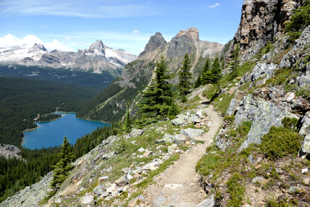
When we reached the lip of the plateau, the valley of the west side opened up ahead of us.
We followed the west trail and then veered east towards the Terrace Pools.
Along the way the setting moon aligned with Schäffer ridge.
A ground squirrel greeted us at the edge of the pools.
A fat young american dipper was following a parent around, begging for food.
If you haven't seen a dipper at work before, or even if you have, its choreography is remarkable.

From the ponds we backtracked to the Opabin Prospect.
Although not as high as some of the surrounding prospects, Opabin still has a marvelous view.
This shot was taken from the prospect, with some of its slabs in view, over towards All Souls. That prospect is located at the shelf where the light gray and tan rocks yield to the dark gray cliffs.
Joan and I then decided to head up the plateau on the west trail, even though that meant some minor repeats.
This photo shows the layout of the ponds and cascades we had skirted earlier.
Soon we encountered the rock pile where two years before we had been charmed by several baby marmots. It happened again; this place must be a good marmot nursery.
A somewhat fuzzy closeup.
There was a final climb up to the level of Opabin Lake. This photo is of the view looking back, with the west trail and Hungabee Lake as prominent features.
Joan and I rested overlooking Opabin Lake. It was a good spot to eat the first half of our lunch.
An american pipit wondered what we were doing.
The next photo captures two trails. Below the tall bluffs is the Yukness Ledges trail, and scrambling uphill below the cliff on the right is the route to Sleeping Poets Pool, which we visited in 2015. Click on the image to enlarge.
After a short stretch on the east Opabin trail we picked up the Yukness Ledges path, which at first winds up through the boulder field hinted at in the lower right corner. We're on our way to Lake Oesa, taking the ledges counter-clockwise this time.
From the higher elevation of the ledges the Opabin Prospect looks like a thumb in the landscape.
At this western end the trail hardly needs alpine route blazes, except for the boulder field at the start.
As it rounds the first corner the route becomes rockier, more up-and-down, and the blazes become more useful.
About a third of the way across the ledges Joan and I paused to finish our lunch. There we also chatted with a young couple who had just come down from the (now defunct) Abbot Hut, a steep, challenging climb that demands gear such as a helmet and rope. The woman was glad to have done it, but never again; several times she'd been in tears at being unable to make progress up the vertiginous scree.

This is what I consider one of the classic Lake O'Hara perspectives, from the Yukness Ledges trail at the midpoint of the lake.
By now it was warm in the sun if the breeze wasn't blowing. But the breeze did deter any bugs fostered by the previous two weeks of wet weather.

This alpine route has a sharp climb or drop, depending on your direction of travel, as it rounds the eastern corner. This photo looks back at the assemblage of blazes and rocky guidelines that steer hikers approaching or leaving the edge of the climb/drop.
This brilliantly illuminated slab bore both the old-style (orange/red) and new style (two yellow bars on blue) alpine blazes. Lake Oesa is in the background.
A hiker passing the other way advised us not to miss the ducks in Lefroy Lake, the pool just below Oesa. Joan and I could see them from the ledges trail, and the water was so clear we could see the paddling feet. (I had forgotten my binoculars today, but Joan would lend me hers from time to time.) The distance was a challenge for my camera.

Lake Oesa was in full sun this afternoon.
From the edge of the lake's basin there was a grand view back to the eastern corner of the Yukness Ledges.
This map shows how the two trails, Yukness and Oesa, form a pocket whose sides face each other.
A stairway begins the trip back down to Lake O'Hara.
The ducks were still at Lefroy Lake, but most of them had hauled out onto rocks.
Then we continued on the familiar trail down to Lake O'Hara, a shower, and dinner.