Showing posts with label galatea lakes trail. Show all posts

Wednesday, November 25, 2020

Canada (2019) Part Nine: Galatea Lakes

Tuesday, Sept. 17 (2019). This was our last hike, the day for us to tackle our "goal" destination after two weeks in the mountains: Upper Galatea Lake. The previous year we'd made it almost to the lower lake, but weather and time had turned us back. We were determined to succeed this time. It would be work; it's a 18.6km/11.6 mile round-trip, gaining 806m/2644 feet to an altitude of 2230m/7316ft.

Joan and I rose early to have breakfast and then grab lunch fixings at the Market Cafe of Pomeroy Kananaskis. We drove out to the Galatea Lakes parking area and hit the trail at 8:00am.

After a brief downhill we reached the bridge across Galatea Creek.

In case you were tempted to ford it --
Shortly thereafter we crossed
a modest footbridge over a tributary flowing down from the mountains; this stream would be with us for miles. At the far side there was a trail sign.
Left green circle, our destination. Right circle, our starting point.
The next section began with uphill switchbacks, followed by repeated crossings of the stream on replacement bridges,
each revealing damage and wreckage from the floods of 2013. Joan and I would eventually cross ten bridges.
This first zone was largely in the woods. Then the trail climbed away from the creek and entered a zone of mixed woods and rock falls. In places the water had cut itself into a deep canyon.
Joan and I noticed,
along a short stretch, several spray-painted purple markings on the trail and finally a purpled stone sitting in the middle of the path. Trail maintenance markings, perhaps? Or hikers from a school with purple colors? Another mountain mystery.

The climb continued with more creek crossings. The way ahead did not yet appear any shorter.

A major landmark was a flat grove suitable for a pause and a bite.

The grove continues to the right of this photo.

Over the last few years Joan and I have discovered the importance of snacks, particularly for me. Last year we made it all the way to Lillian Lake before eating anything, and Joan told me that by the end I was plodding in slow motion. After sharing a chocolate bar with her, I took off so fast she could barely keep up. (My fasting blood sugar is near the low end of normal). This time, we were stopping every 90 minutes or so for a small snack -- usually dark chocolate from Le Chocolatier -- and my efforts were much steadier.

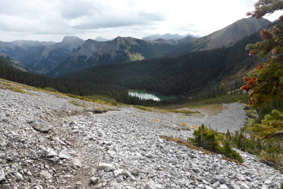
Flood damage is visible most of the way to Lillian Lake.

After climbing a final, stubbornly steep stretch we emerged on her shores.

This photo looks back the way we've come.

In season Lillian is mobbed by overnight campers, but in mid-September it was deserted. She does host, however, a spiffy solar-powered biffy, and most welcome it was.

After another chocolate stop Joan and I continued up wooded switchbacks until we emerged into the rocky zone.

That saddle is Guinn's Pass, even higher than Galatea.
It's still uphill from here! Looking back at Lillian ...

The trail marker where the path to Guinn's Pass intersects.
We approached the lower Galatea Lake.
The route to the upper lake dipped down to the shoreline and then hopped over that far ridge, revealing this view.
Joan and I continued on the path at far right in the above photo, searching for a congenial lunch spot. We chose this one.
The prominence is Mount Galatea, the highest point in the Kananaskis range at 14,500 ft. During lunch we spotted a golden-crowned kinglet, and, high above, a golden eagle cruising around the peaks. Next, a more panoramic view of the upper lake.
Joan and I explored a bit of the terrain. There were several shallow bear diggings, indicated yummy bulbs had been present. Deeper diggings would have indicated that the target was ground squirrels.
The view from the shore of the lower lake on our return.
We spotted our first fellow hikers of the day, two figures ahead of us on the Guinn's Pass trail,
Click on the image to enlarge.
who disappeared from view as we marched on. When we reached the junction Joan and I met two women from Red Deer who also decided to tackle the pass. Then we saw people coming up from Lillian Lake; clearly, the wave of those who start later was catching up to us.
On our way back ...
We paused on the Lillian Lake shore for another snack and biffy visit.
Among the incoming hikers was family of three: Mom, Dad, and a toddler carried high in a backpack by Dad so the kid could see ahead. Balancing that load must be an acquired skill.

A bold chipmunk kept an eye on us, probably a least chipmunk.

The sun played peek-a-boo, sharing time with brief showers that lasted just long enough to persuade us to don our rain jackets. But our return hike was basically dry.

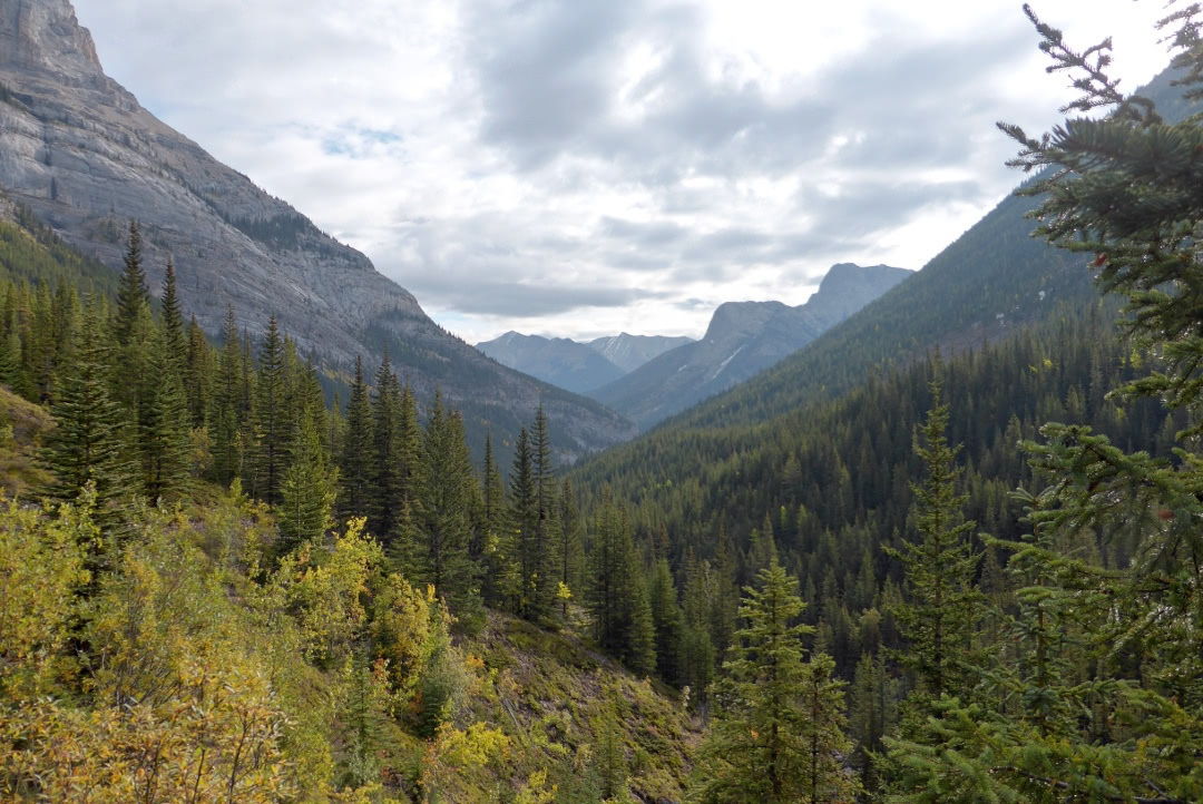
Heading down the valley.
The air grew warmer as we descended. Late-starters were having fun on and around the bridges lower down. Finally Joan and I reached the parking area at 5:15, 9¼ hours after setting out, a pace of 1.15 miles per hour -- including snack stops, lunch, bird identifying, gazing at mountains, and so forth. Because of these factors our hikes are often in the 1¼ to 1½ mph range.

One woman in the parking area, with husband and dog waiting in the wings, asked Joan, "How far is it?" Joan replied,"Where are you going?" Her response, "Where did you go?" Joan: "We started at 8:00!" With that our questioner lost interest.

The following day was our last in this visit, and after checking out we drove down to Canmore to browse shops and art galleries. Of course, we swung by Le Chocolatier to pick up treats for ourselves and friends and neighbors back home. Large interior windows provided a view into the works.

We also spotted a hang glider gradually descending over the town!
Then it was on to Calgary and the airport hotel, where we had dinner with Barry Ronellenfitch, who I met almost two decades earlier at a retreat. The next morning Joan and I flew off on a day-long trip back home.
This Canadian visit was another great success; we do love the mountains. Our plans for 2020 were made over the next few months, but then upended by the coronavirus. Our fingers are crossed for 2021.

Wednesday, January 30, 2019

On the 15th Day of Hiking (Galatea Lakes)

The Galatea Lakes were one of our "goal" hikes this year. Joan and I had explored the lowest reaches of the trail last year, but that barely scratched the surface. We had a quick breakfast at the Market Café in the lodge and purchased sandwiches, cookies, and chocolate from Le Chocolatier for lunch and trail snacks.

The forecast called for showers by 3pm, but Mount Kidd glowed at the Galatea Trail parking area.
We're the only ones, shortly before 9:00
After a quick descent to the Kananaskis River the first and largest bridge of the journey appeared.
Soon there was another bridge, surrounded by the rubble from the 2013 flood.
On the far side, a trail map.
The sign says Lillian Lake, 5.5km / 3.4 miles, Galatea Lakes 6.6 km / 4.1 miles. Another source puts the Lillian Lake round trip at 14.3 km -- YMMV. The altitude gain estimates range up to 2850 feet (870 m) to Galatea so the distance feels greater.

The trail ascends the creek valley, sometimes with switchbacks, sometimes almost level. We passed at least one trailcam.
One of the many bridges in the first third of the trail. (The 2017 blog entry contains many more photos of this stretch.)
This image looks back to our origin, early in the hike. About this time the trail crossed a rocky avalanche path; there we were passed by four men, two young men that sounded Canadian and two older Asian men.
Periodically we stopped to take in the scale of the flood damage, immense even five years later.
As we continued to climb Joan and I passed above several slot canyons with narrow waterfalls. Steep, sketchy side trails led down to some of these and might have offered a better view, but we decided not to take the risk.

One oddity was plastic bags of dog poop abandoned by the side of the trail. Hey, if it's in a plastic bag, why not carry it out?

The bridges became more modest as we went up and up. Lingering snow appeared.
Smaller bridges for the narrowing stream.
What Joan saw:
Not going off-trail here!
Prior to the 2013 floods the Guinn's Pass trail departed from the Galatea Lake trail a couple of kilometers before Lillian Lake. It was a brutally steep climb, and prone to erosion. That route has now been moved, but I failed to photograph the closure sign for the old trail. In effect, the direct climb up was replaced with a huge switchback: proceed past Lillian Lake to not far from Galatea Lake, and there's the new Guinn's Pass trail.
We had seen Guinn's pass from Buller Pass two days ago.

Joan and I crossed a two-log, no-railing footbridge and reached Lillian Lake. We continued to the far side, next to the campground, where we sat on a bench and split half a chocolate bar.
The four hikers that had passed us earlier were a bit further along the shoreline, as seen above. We could hear one of them say, "So, Mr. Lee, do you have any children?" Aha. The two Canadian guys were acting as guides for visitors.

As Joan and I prepared to leave a loud buzzing noise burst the quiet, a sound of angry hornets. They were flying a drone! Which is illegal inside a national or provincial park without a permit, and we were suspicious that these men did not have one, but were taking advantage of a weekday in the off season.

We climbed through a series of switchbacks rising behind Lillian Lake until the trail emerged into a rocky zone,
Looking back at Lillian.
where it more or less went straight up. We followed a series of cairns through the scree, and discovered that the first bench wasn't the summit. We paused here to grab a quick lunch -- half a sandwich and a big cookie -- and pressed on.

It wasn't long before we reached the Guinn's Pass intersection.
This sign is puzzling. It looks like it's been played with, and now makes no sense. Only 0.4km to the Ribbon Lake Campground? No way. Even as the crow flies it's a good 2.25 km to the campground! (Click on the image below to enlarge.)
And much further than that by trail!
Up here amidst the rocks we encountered two pikas. True to form, they made several warning eeep! calls.
Cute little critters, full of hustle.
Joan and I went a bit further to get a good look at Lower Galatea Lake.
The upper lake is beyond the rise at the far end.
There were clouds rising from the valley and occasional snow flurries. We decided there wasn't time, nor was it good weather, to press on to the upper lake. Soon after we began our return Joan took a photo of me, a rarity in this blog.
As we headed back down to Lillian the air warmed; the snow flurries intensified and mixed with drizzle.
At the lake we took advantage of a fabulous new biffy at the campground.
A solar powered composting toilet, with a triumphal arch, scalloped edges to the walkway, translucent roof, and best of all, separate ladies and gents rooms!
The pig and frog accompanying us on this hike went into our packs as we dressed for wet weather, which it was all the way down. Here's a photo of our hiking companions from earlier in the trip:
Dart, on the left, and Kristinn
Not so far below the lake we encountered fifteen young men and women headed to Lillian Lake to begin several days of back country camping. In the manner of youth they were carrying heavy loads, no two of which were the same, many with items exposed to the weather. They were full of enthusiasm but weary of the uphill slog, so we were happy to tell them "it's not far."

The rain intensified. Although downhill is faster than uphill, it seemed much longer. We passed two more backpackers headed to the lake. Then, at the end of one of the lower bridges, Ben slipped on the last step. His rain pants and pack cover were muddied, but no damage was done.

Back at the hotel we draped outerwear and accessories everywhere to dry; fortunately even in wet weather things indoors (and warm) dry rapidly.

Tomorrow, new road as well as new trail. What will the weather bring?