Showing posts with label alpine helicopters. Show all posts

Thursday, March 16, 2017

CR2016: On to Purcell Mountain Lodge

Joan and I awakened early for our helicopter flight to Purcell Mountain Lodge. First, because we had been told to be at the Golden airport by 7:15. Second, the hotel was hosting a full busload of Chinese tourists, and we needed to get to the breakfast buffet before it was gone.

After parking at the airport we turned over our keys to the staff, in case the autos in the fenced lot needed to be reshuffled while we were away. We and our baggage were weighed. There is a theoretical weight limit of baggage per passenger, but in practice, if the whole load doesn't breach the helicopter's capacity Alpine Helicopters doesn't bother to weigh individual bags. Joan and I spent time the night before reorganizing our luggage to meet the requirement anyway, and we left unnecessary stuff in the car trunk.

Bear spray must be separate and must travel in the external luggage box.
It would take three round trips to ferry all the guests, staff, and supplies to the lodge.
About a 15 minute flight.
Soon after takeoff Joan introduced Margie and Rita to a fellow passenger.
The route took us over the Kicking Horse Resort, just outside Golden.
The chopper was climbing steadily to get over the first mountain range.
Higher ... higher ...
Over the top.
The pad at Purcell Mountain Lodge requires a precise landing at 2200 meters, or 7200 feet.
Snacks and lunch fixings were available, and our first guided hike began at 11:00. There were plenty of trails around the lodge,
and our guides Sarah and Kristin started us heading north and west through the meadowland, where we encountered both flowers and hummingbirds. (Given that our cook was Grace and the lodge manager Cherise, it was an all-female staff for this rotation.) The Selkirk mountains dominated the western horizon.
The tallest one, towards the right, is Mount Sir Donald
A closeup of those mountains.
The brown smudge on the right side of Sir Donald (the tallest peak) and the glacier beneath was a major rockfall from just one week ago, reported to Parks Canada by Sarah.

Our group turned to the south. Looking to my left, I took this photo of the main lodge (right) and auxiliary building.
This photo zooms in on a section of the Selkirks with a tongue of the Illecillewaet Glacier (top) and a waterfall (bottom.)
Our guides then took us down the west side of the meadowlands towards the "Kneegrinder."  Sarah acquainted us with the term "lava tree," implying its function, "lavatory."

We stopped on top of the Grinder for our lunch break.
Afterwards our group continued on, skirting the National Park boundary.
We soon encountered a ptarmigan.
And one of its youngsters.
Still sporting some down.
This panorama encompasses most of our hike. The bright spot in the center is the lodge roof.
The bright streaks are created by the camera's stitching function.
We returned to the lodge to settle into our rooms and clean up. At Purcell each room has its own vanity and sink, and across the hall are three private shower rooms and three private water closets, with the lights on timers that the user sets. For a back country lodge this was very posh.

At the beginning of August sunset is still very late.
Tomorrow Sarah and Kristin will take us, huffing and puffing, to the top of Copperstain Mountain.


Wednesday, December 23, 2015

CR2015: From Mistaya Lodge to Mt Engadine Lodge

Today was a transit day; Joan and I are flying out of Mistaya Lodge and driving to Mount Engadine Lodge. Our pigs, Knuckles and Pierre, were ready to go first thing in the morning. They like helicopter rides.
It promised to be another sunny day.
There's a hummingbird feeder on the south side of the lodge that is much less fought over than the east side feeder.
After carrying departing guests' gear out to the helipad, David and Sandra struck a well-practiced pose for the camera.
Our chariot arrives.
Joan and I, on the first group out, will be dropped off at a back-country landing point, and then driven the rest of the way back to Golden. The chopper will also drop off garbage and pick up supplies and incoming guests at the landing point. Only the last group in the changeover will fly all the way to Golden.

The latter half of the flight follows a valley with a braided glacial river.
Today I had the privilege of sitting in the jump seat, up front next to the pilot. Here's what the instrument panel looks like.
This video clip covers the first 90 seconds of our flight, and the last 90 seconds.

As you can see, the whirlybird kicks up a lot of dust. As a confirmed eyeglasses wearer and a camera-pointer, I hate dust, especially gritty outdoor chaff. While the others huddled behind an SUV while the heli took off, I hightailed it across the road.
The Mistaya Lodge folks drove us back to the heliport in Golden, where we retrieved our rental car. The remainder of the day would be spent driving to Mount Engadine Lodge. We could pick up some new road, and road we hadn't driven on in several years, by driving down to Radium and then back up Highway 93. It would be longer, but also avoids a chunk of driving on the Trans-Canada at the end of a holiday weekend.
The drive down to Radium had little traffic. The sharp northward jog on Highway 93 after leaving Radium hosts a viewpoint that looks up and down the Kootenay Valley. The haze in this photo was generated mostly by forest fires elsewhere.
While at this overlook we saw bicycle riders obviously participating in some event; there were support vehicles parked across the road from the viewpoint, they had numbers on their jerseys, and so forth. We chatted with one of the organizers, a guy originally from Chicago, and discovered that this ride was one of the ongoing activities of Sea-to-Sea, an anti-poverty organization.

On arriving at Mount Engadine Lodge we were told that the Moose suite, our favorite, was not available, even though we had reserved it nine months before. As we unpacked in the Elk suite, Joan and I discovered that two light bulbs were burned out. They were quickly replaced by the staff, but we knew the Lodge had changed ownership and management since last year, and this was not an auspicious start. That night's dinner was still excellent, however, and the major question seemed to be tomorrow's weather.

Saturday, December 5, 2015

CR2015: On to Mistaya Lodge

It was the last day of July, and Joan and I were on our way to Mistaya Lodge, our first visit to this family-run hiking and skiing resort. We arrived early in the morning at the Alpine Helicopters facility in Golden, checked in, and our baggage and our selves were weighed. Renee and Edith, who we had seen several times at Lake O'Hara, arrived on an incoming helicopter ferrying passengers back from Purcell Mountain Lodge. After a brief reunion with the Swiss couple, Joan and I queued up at our helicopter.

As you can see, it was a sunny day, and the sun-lit side of the chopper quickly became hot. But the views were great.

Here is a video, in three parts, of the helicopter activity that day: from inside the aircraft as we take off, from outside watching it land, and watching it take off.

At the lodge we had another reunion, with Wood and Chantal, who we had met a few years ago at Talus Lodge. Then our first activity was taking our luggage to our room.
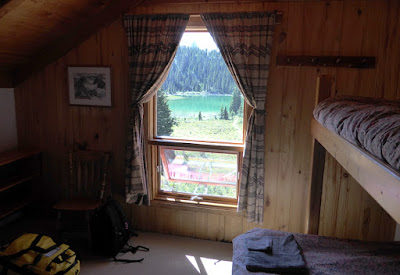
The view from the window looked south to "the lake."
Then it was time to fix our packed lunches and head out on a guided hike to Boomerang Glacier. In this screenshot from Google Maps, Mistaya Lodge is the red roof circled in yellow (click to enlarge), and the glacier is at the lower left; we're heading towards the face noted in red. Its curved shape gave it the name "Boomerang."
First we walked down to the braided creek below the lodge, where a mini-hydro electric generator is located.
Then it was up the first moraine, skirting the right edge of the small lake circled in blue.
We continued to climb closer to the faces of the peaks. This one displays a huge slab of fossilized stromatolites, mounds created from mineral grains glued together by cyanobacteria in shallow water. The tectonic forces that created these mountains have forced the ancient seabed (as much as 3.5 billion years old) almost vertical.
From this same location, a rest stop, I took a panoramic photo to the east.
Just a few minutes after starting up again, we encountered a mama ptarmigan,
accompanied by three chicks.
Up and up we went, generally bearing north (this photo looks south).
Then we reached the front of the glacier,
 and dropped our packs.
The photography geeks marched up to the glacier's foot to take pictures, despite warnings from our guide, Sandra, that ice melting in the July sun might let loose a rock at any time. I used a zoom to take this photo; I suppose if the shutterbugs weren't there for too long, the risk was low.
Here several of us gather around Sandra for a talk, perhaps about the geology of the area.
Far below us, part of the trail home passes through a grassy area.
A narrow ridge gave Sandra an opportunity to offer a photo-op to any of the participants. We took her up on it.
We were well and truly tired by the time we returned the lodge, and an excellent supper was appreciated by all. This final photo takes in the view of the lake by the lodge in the early evening light.
Tomorrow Joan and I must decide whether to take the all-day guided hike to West Mistaya Peak, at 9500 feet, or an easier alternative.