CR2012: Lake MacArthur
On the next morning, the weather looked very promising,
so Joan and I set out for Lake McArthur. Our favorite route is to begin with the Big Larches trail, which although steep in spots offers some inspiring views. Others may take the trail that goes through the Alpine Meadow, past the Elizabeth Parker Hut, but we find that option less interesting. When leaving from the shores of Lake O'Hara, there are several destinations, including Mary Lake, but the signs will take you through the intersections -- though you should always have a trail map!
The first portion of the trail winds through the forest,
with some modest uphills and downhills. Shortly you will reach one of the two distinguishing features of the Big Larches trail, the scree fields that have tumbled down from Mount Schäffer. (The other is the larches, most prominent in the autumn when they turn yellow.) The trail skirts the edges of these, but doesn't try to take you through them.
The middle section of the Big Larches trail is the steep part. Essentially, you are taking a staircase up along the edge of the rock flow. But the presence of that rock flow, by replacing trees, offers you a wonderful low-altitude look back at the O'Hara basin.
In this picture, Mary Lake is peeking through the woods at right, just below the Opabin Plateau. In center you can see Lake O'Hara and the succession of small ridges that intrude on the valley that lifts you to Lake Oesa, and the Wiwaxy peaks are at far left.
A few minutes after I snapped that picture a butterfly greeted us.
After the climb along the rocky fringe, the trail becomes much gentler, and soon after passing the turnoff for the All Souls' Alpine route, you arrive on the shores of Schäffer Lake, at precisely the same spot where the Alpine Meadows route disgorges its followers.
The mix of rocks and trees on the far side of Schäffer Lake is where we're headed. The trail goes by the right side of the lake, and we take the left-hand choice at a fork. The right-hand choice leads to McArthur Pass and the Odaray Highline, which is limited to four parties per day because that territory is an important wildlife corridor. Grizzlies, cougars, moose, wolves, porcupine, mountain goats, and even wolverines are known to use it for travel between mountain valleys. Not everybody observes the restriction, unfortunately, but we do. In the next photo, we've begun to climb that bump on the far side of Schäffer Lake.
Soon we can see into the McArthur Valley.
We're still in the boulder fields of Mount Schäffer and Schäffer Ridge, and we will continue to be. This is prime marmot and pika territory; we've seen them in the Big Larches section and in the sections to come. Within a few minutes, we see a family of four marmots, and two youngsters are tussling.
Soon you are confronted with a choice, if you haven't decided already: there are two routes to the northwest shore of Lake McArthur, the high-level circuit and the low-level circuit.
The high-level circuit is rockier and has some steps that we'll see shortly; the low-level circuit is less rocky but causes you to lose and regain altitude. Joan and I prefer to make a loop of it, and today we went in on the high-level trail and came back by the low-level trail.
Just a few minutes beyond the sign I took this photo; the trail winds along the left side. Lake McArthur is tucked at the foot of the mountain on the far left, Park Mountain.
In the next photo, the high-level trail approaches a brief section of stone steps.
Here's a closeup. Fortunately, you don't have to climb all the way up; the trail follows one shelf to the right and then continues on.
The trail bears to the left and becomes much less rocky, but is still climbing.
When the high-level trail passes through the meadow, your steps quicken; you know you're getting close.
The debris flowing down from Schäffer Ridge, on the left, shows two simultaneous color themes, an almost-mixing of two different geological eras.
Then, after we climbed the last rock outcrop, Lake McArthur appeared. The wind was still, leaving the lake a mirror for the mountains and the snow.
When we arrived near the shore, we were reminded all over again why Lake McArthur was the favorite spot for Joan's father. As with all alpine lakes, the sun and clouds can change McArthur's appearance several times during a lunch.
There was still some ice on the lake,
and the water level was a couple of feet higher than usual, spilling over the low point in the trail, where the high-level and low-level circuits meet.
The low level trail, on leaving McArthur, drops down to the west of the high level trail.
The low level trail descends and then immediately regains that altitude. In this photo, we are partway down this descent, and we know we must regain the top of the far rock pile.
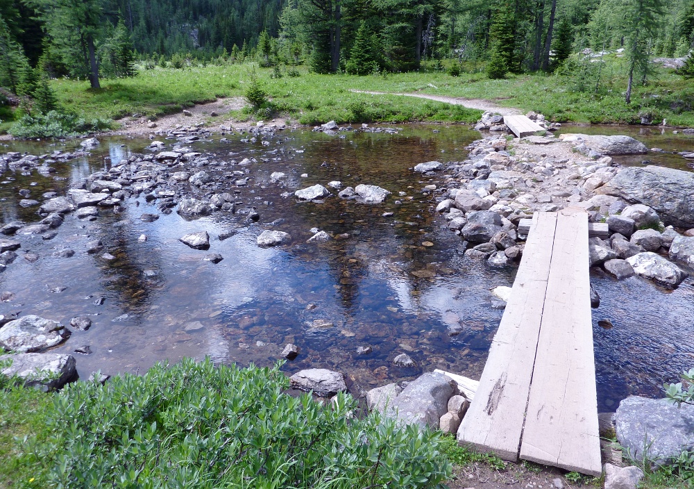
We arrived back at Schäffer Lake, where two footbridges span the outflow.
Looking back at the lake from the bridges.
Although we were three-quarters of the way back to our cabin, the wildlife encounters weren't over yet. The Big Larches trail treated us to a view of this pika.
These critters don't stand still. They are busy harvesting forage for the long winter ahead, occasionally stopping to scan their surroundings, perched atop a large rock, and letting loose with a high-pitched "eeeeep!". I managed to get a picture of this fellow carrying provisions back to his larder.
After returning to our cabin and cleaning up, it was time to think about our own provisions, which meant strolling to the lodge for dinner. In this photo, the gong has not yet rung.
For the last few years the Lodge has adopted a seating system that Joan calls "speed dating," in which you get different tablemates each evening. You can, of course, request to be seated with a specific party, but we've met such a wide range of people this way that we prefer it.
Tomorrow we'll tackle Sleeping Poets Pool and the Yukness Ledges.


No comments:
Post a Comment
Comments may not appear immediately as they are moderated by the author to eliminate spam. Please, no commercial links!