The next day, after a breakfast feast at Canadian Artisans Bed and Breakfast,
we set out to hike the Deer Ridge Trail, off Highway 68, near Sibbald Lake. The westernmost section of 68 is unpaved almost until the Sibbald Lake parking area; however, the gravel road was in good condition when we were there. This terrain-view from Google Maps shows the spur road to the parking area, the hills and ridges, and a large unnamed lake/pond.
we set out to hike the Deer Ridge Trail, off Highway 68, near Sibbald Lake. The westernmost section of 68 is unpaved almost until the Sibbald Lake parking area; however, the gravel road was in good condition when we were there. This terrain-view from Google Maps shows the spur road to the parking area, the hills and ridges, and a large unnamed lake/pond.
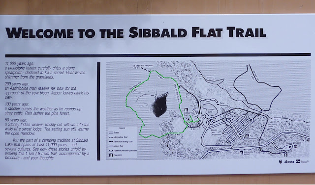
This sign says 'Sibbald Flat Trail,' but there are several trails from the parking lot. I've highlighted the route Joan and I took in green (click to enlarge).
Here is a photo of our rental car, Mr. Steed. We could get all three duffels into his trunk, so we were very happy with him, even if we had to mash the gas pedal to get his attention. The base model Avenger has a four-cylinder engine with a four-speed automatic.
In the parking area we were briefly welcomed by a bald eagle. This we considered a good omen.
In the center of the meadow is the remains of a Stoney Indian sweat lodge, about 50 years old, as described in the trail sign above. Here is a zoom-in on the lodge.
The first section of the trail weaves through an open mass of young trees.
This was in late July 2012, a year in which spring had been delayed a couple of weeks by a heavy winter snowpack. On our first hour we stopped often to inspect blooming flowers and flitting butterflies.
Our trail wound along until it split; the right-hand fork continued on to Eagle Hill, while we took the left-hand choice and soon entered an open meadow. Here, in the tall foliage, the trail to Deer Ridge took a 90° turn. It would have been easy to miss the turn, and bash on through the meadow, except that the correct trail was visible as a straight-line cut up the side of Deer Ridge. Too narrow for a utility right of way, nonetheless it was cut as unwavering as if with a straightedge. We climbed.
It was good exercise for us, this otherwise modest climb. We had not been able to prepare for hiking in the Canadian Rockies this year, as was our custom. One reason was the extreme temperatures in Ohio in June and July, with days on end of high temperatures between 90°F - 100°F, and matching humidity. Also, about six weeks before our departure, Joan broke her little toe. Thus our plan was to start with the same degree of difficulty we would have employed for training and, we hoped, work our way up to our "goal" hikes for this trip. I should also note that while we live at an altitude of about 800 feet, this first hike fluctuated around 5,000 feet. Our lungs huffed and puffed.
The view from the top was more than we had hoped for. We were perched just above Sibbald Creek, which stretched away in both directions. First, here is a view looking to the southwest.
And now an overlapping view to the southeast.
The crest was a wonderful spot to munch lunch and watch the comings and goings on the highway. At the end of lunch we discovered that the Calgary skyline was visible to the east!
We descended the ridge and entered the first meadow at the end of the pond.
There we encountered swarms of gorgeous blue damsel flies. I couldn't capture a photo of one on the wing, but occasionally one would alight for a few seconds.
On our way back we reached the spur trail for a viewpoint atop the first ridge -- you can see it on the trail sign photo if you click to enlarge. This viewpoint gave us a look down to the meadow we had just crossed.
The benches at the viewpoint had an odd construction I had never seen before. Was it intended for people with backpacks? Accomplished slouchers such as myself? I gave it a quick try and found it uncomfortable.
We returned to Mr. Steed, but instead of returning directly to Highway 40, we drove less than a mile further, to take in two viewpoints down the valley of Sibbald Creek. The cone-shaped ridgetop towards the right is where we lunched.
This hike was much more enjoyable that we had expected. It wasn't a long march to a glorious alpine view, but it suited us exactly as an initial hike. Joan called it "the perfect prescription."


No comments:
Post a Comment
Comments may not appear immediately as they are moderated by the author to eliminate spam. Please, no commercial links!