Showing posts with label sibbald flat trail. Show all posts

Saturday, February 9, 2019

On the 16th Day of Hiking (Jumping Pound Summit)

On September 21st Joan and I ventured into new territory. We had visited Sibbald Creek and the Deer Trail six years ago, but today we drove past them and plunged south on the unpaved Powerface Trail, heading for the Jumpingpound Summit trailhead.
After we turned onto Powderface Trail there was a sign advising "Powderface Trail not suitable for travel, travel at your own risk." It's a long, narrow road that must be shared with logging trucks. Fortunately we encountered only one truck; I steered close to the edge of the road, and everything went OK. Later the Trail widened and even left us a place to park across from the start of the hike.
When we pulled in there was a trio also getting ready, two sisters and a husband. The ringleader, from Calgary, had a daughter who attended the Cincinnati Academy of Music, and the couple lives in Ontario, just across Lake Erie from Ohio, our home state. They set off ahead of us and stayed ahead.

The beginning of the route was flat, but soon turned into switchbacks. Jumpingpound Summit is considered a half-day hike with a distance of 3.4 km / 2.1 miles to the summit with a gain of 417 meters / 1370 feet. Weather permitting, Joan and I hoped to lope along some of Jumpingpound Ridge as well.

At one point there was a side trail leading to a bench and a view. We were again climbing into a region of wet, drippy snow.
We continued up to the ridgeline and turned left towards the summit. After a while we broke out of the trees.
Joan and I started up the summit spur, and soon the trio was converging with us. They had gone a short way past the summit on the ridge trail before deciding to turn around. We fell in with them and it was a short climb to the top.
You're seeing the last few feet of the summit.
The patchy network of bright and dark around us played hob with my camera; nonetheless, clear-cut logging areas can be seen in the right of this photo, just below the clouds. (Click on the image to enlarge.)
From the summit we could see the ridge crest stretching away, beckoning to us,
but the leader of the trio was adamant that her group would go back down. She was concerned that the clouds blowing in would create a whiteout, and although skeptical Joan and I joined them in the descent.
Going back down carefully.
Back on the ridge trail the leader showed us what she thought were grizzly tracks. The snow had melted too much for a definitive ID, but the trio had seen the impressions earlier and in undisturbed snow.

Joan and I stopped for a quick chocolate-bar break as the three went on. Then we started down, down in the drips and slush. Again we had been transported to the Holodeck and the trek had altered itself to make the return much longer than the outbound slog.

We had lunch the parking area and continued to chat with our fellow hikers. Then Joan and I drove south on Powderface, including a couple of muddy hills on which I held my breath, hoping the car wouldn't lose traction. We reached the Elbow River and paved Route 66, and by this time we were in the midst of fog. There were road signs warning "stock at large next 44 km," and we did see plenty of cattle, through mists that waxed and waned.

Our vehicular expedition turned onto 758 and into the town of Bragg Creek, and finally up 22 to the Trans-Canada Highway, where we turned west. On reaching 40 we turned south and stopped at the Barrier Lake Information Centre to donate our now surplus bear spray, and report the drone flight at Lillian Lake yesterday.

The warden at Barrier Lake couldn't take the report herself, but had to call Kananaskis Emergency Services and then hand me the phone to make my report. We learned that not only was a permit required, but permit holders must post notices around their flight perimeter to preserve the privacy of others. We sure hadn't seen any notices!

By the time we returned to the lodge some sunshine had begun to poke through the clouds, and we were able to pull our dinner reservations 45 minutes earlier. Rain and wind began while had our evening meal.

The next morning, our final day in Canada, revealed a couple of inches that had fallen overnight. It had been that kind of September, snowing overnight and melting grudgingly during the day.
The view from our lodge balcony.
Joan and I had time to indulge in a restaurant breakfast before completing our packing. There was a low cloud ceiling, but we hadn't planned on hiking today anyway. We drove into Canmore and our first stop was Le Chocolatier, where we stocked up on chocolate bars and other treats for ourselves, neighbors, and former neighbors. Then on to pick up two tubes of Voltaren, a pain relief cream not available in the U.S., based on two recommendations during this trip. Joan reports that it didn't do much.

We parked in the center of Canmore for browsing, picking up a new GemTrek map (the best!) and a track and scat ID book, and visiting several art galleries. In the midst of this it began to snow and sleet, and after one or two more stops we decided it was time to move on. Snow had already accumulated on the car.

Joan and I thought to visit the Chiniki cultural center on our way back to Calgary, but it was either well hidden, or closed for the season. We scouted out the associated convenience store/gas station at that exit but there wasn't much to see.

We had dinner at the airport hotel with our Calgary friend Barry, and afterwards rearranged our luggage to protect the chocolates in our carry-ons and to put banned items, such as Swiss Army knives, in the checked luggage.

The next morning I took a couple of interesting photos before our plane left. Here's a hazy look at the Calgary skyline:
We spotted this aircraft, painted in the original Trans-Canada Air Lines colors to celebrate 60 years of service, 1937-1997. Trans-Canada eventually became Air Canada.
I'm surprised they didn't repaint the tail for the 75th in 2012.

The weather in the Canadian Rockies was a challenge this September of 2018, but we're still very glad we came.

Thursday, August 16, 2012

CR2012: Sibbald Creek and Deer Trail

The next day, after a breakfast feast at Canadian Artisans Bed and Breakfast,
we set out to hike the Deer Ridge Trail, off Highway 68, near Sibbald Lake. The westernmost section of 68 is unpaved almost until the Sibbald Lake parking area; however, the gravel road was in good condition when we were there. This terrain-view from Google Maps shows the spur road to the parking area, the hills and ridges, and a large unnamed lake/pond.

View Larger Map

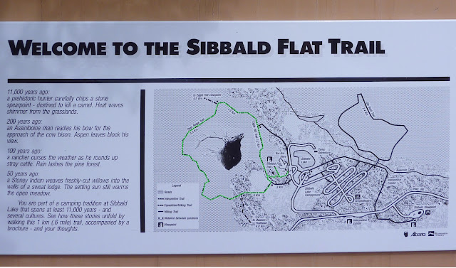
This sign says 'Sibbald Flat Trail,' but there are several trails from the parking lot. I've highlighted the route Joan and I took in green (click to enlarge).

Here is a photo of our rental car, Mr. Steed. We could get all three duffels into his trunk, so we were very happy with him, even if we had to mash the gas pedal to get his attention. The base model Avenger has a four-cylinder engine with a four-speed automatic.
In the parking area we were briefly welcomed by a bald eagle. This we considered a good omen.
The Deer Ridge trail begins by following the flank of a ridge overlooking a large meadow and pond.
In the center of the meadow is the remains of a Stoney Indian sweat lodge, about 50 years old, as described in the trail sign above. Here is a zoom-in on the lodge.
The first section of the trail weaves through an open mass of young trees.
This was in late July 2012, a year in which spring had been delayed a couple of weeks by a heavy winter snowpack. On our first hour we stopped often to inspect blooming flowers and flitting butterflies.
Our trail wound along until it split; the right-hand fork continued on to Eagle Hill, while we took the left-hand choice and soon entered an open meadow. Here, in the tall foliage, the trail to Deer Ridge took a 90° turn. It would have been easy to miss the turn, and bash on through the meadow, except that the correct trail was visible as a straight-line cut up the side of Deer Ridge. Too narrow for a utility right of way, nonetheless it was cut as unwavering as if with a straightedge. We climbed.

It was good exercise for us, this otherwise modest climb. We had not been able to prepare for hiking in the Canadian Rockies this year, as was our custom. One reason was the extreme temperatures in Ohio in June and July, with days on end of high temperatures between 90°F - 100°F, and matching humidity. Also, about six weeks before our departure, Joan broke her little toe. Thus our plan was to start with the same degree of difficulty we would have employed for training and, we hoped, work our way up to our "goal" hikes for this trip. I should also note that while we live at an altitude of about 800 feet, this first hike fluctuated around 5,000 feet. Our lungs huffed and puffed.

The view from the top was more than we had hoped for. We were perched  just above Sibbald Creek, which stretched away in both directions. First, here is a view looking to the southwest.
And now an overlapping view to the southeast.
The crest was a wonderful spot to munch lunch and watch the comings and goings on the highway. At the end of lunch we discovered that the Calgary skyline was visible to the east!
We descended the ridge and entered the first meadow at the end of the pond.
There we encountered swarms of gorgeous blue damsel flies. I couldn't capture a photo of one on the wing, but occasionally one would alight for a few seconds.
On our way back we reached the spur trail for a viewpoint atop the first ridge -- you can see it on the trail sign photo if you click to enlarge. This viewpoint gave us a look down to the meadow we had just crossed.
The benches at the viewpoint had an odd construction I had never seen before. Was it intended for people with backpacks? Accomplished slouchers such as myself? I gave it a quick try and found it uncomfortable.
We returned to Mr. Steed, but instead of returning directly to Highway 40, we drove less than a mile further, to take in two viewpoints down the valley of Sibbald Creek. The cone-shaped ridgetop towards the right is where we lunched.
This hike was much more enjoyable that we had expected. It wasn't a long march to a glorious alpine view, but it suited us exactly as an initial hike. Joan called it "the perfect prescription."