September 9th began with another chat with Val, Bob, and the Dutch couple also staying at Canadian Artisans. Joan and I picked up further lunch fixings on top of items (cheeses, cookies) Val had left for us and drove out to the Grotto Canyon trail head, arriving at 10:30. We had visited the canyon once before, prior to the 2013 floods.
The signs at the start. Today, all the dogs we saw were not on a leash. At least we weren't buzzed by a drone.
The first stretch of the trail passes just north of a BayMag MgO (magnesium oxide) plant.
Even before reaching the mouth of Grotto Canyon we passed a small wash that bore the scars of the floods.
And then a larger wash, but still not the big show.
Today was even smokier than yesterday. The wildfires, although not approaching Canmore, weren't that far away as the raven flies.
Joan and I reached a bench that overlooked the main outflow.
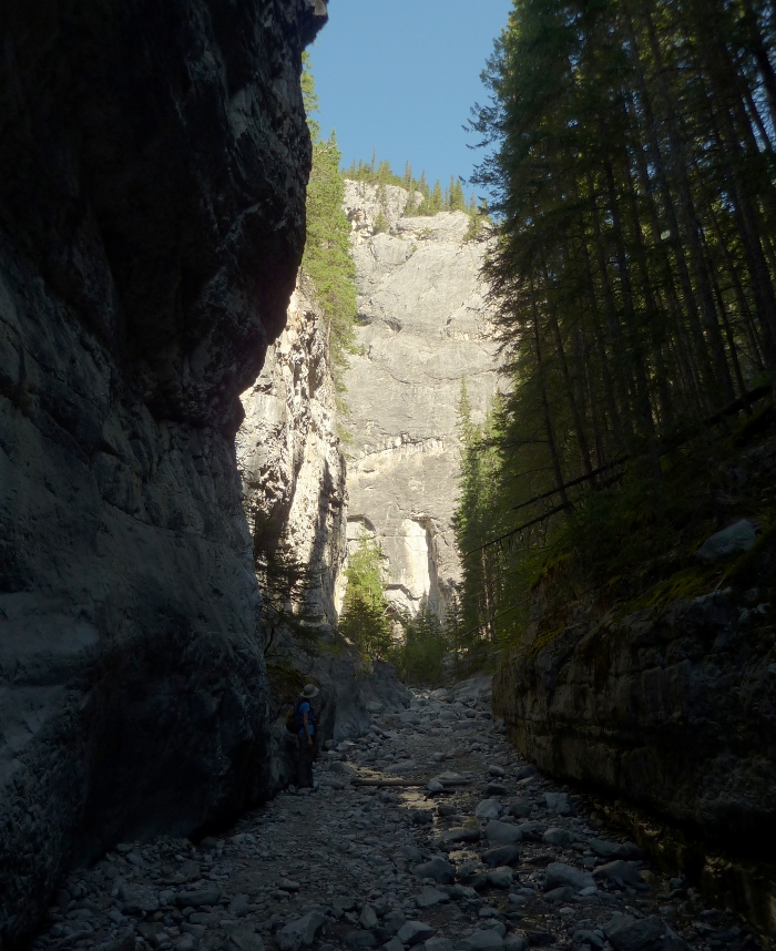
We scrambled down a boot-beaten path into the gravel meadow, and after heading uphill a short distance, I took this picture looking back.
Where the flood plain narrowed into the constricted canyon Joan and I were forced to clamber over a boulder. Then we saw the rock-filled creek bed, with no water in sight. It created a broad road here in the lower reaches.
The canyon quickly narrowed.
The walk to the waterfall was uneventful. Here are two photos of it from 2011:
Water was flowing today as well, even in the dry weather, so it's likely spring fed. Joan and I continued to the left, away from the waterfall,
and met a great surprise. A rock garden had sprouted after the flood! (Click on the image to enlarge.)
The fad of creating balancing rocks
and fanciful shapes, such as this rock person,
had caught on here.
The canyon doglegged to the right, and yet more rock assemblies presented themselves.
We passed a family busy adding more, one per person.
Joan and I continued up, and beyond the rock garden there were few other people around.
We passed this tree island. It's a non-lithic hoodoo, and who knows how much longer it will survive?
Grotto Canyon offers more challenging, or at least taller, rock climbing than Heart Creek.
Past the climbing wall the proportion of large boulders steadily increased -- the heaviest objects will fall out of a flood first. Joan and I would stop now and then to choose our route, around or on top of them. Now there were no other hikers.
We encountered our first pika of the trip. Yay!
The canyon goes as far as you care to take it.
We stopped for lunch, and saw our second pika.
And a moth visited us.
It was time to head back. All three rock climbers were on the cliff face now. Soon after passing them we met a couple from Mexico City. It was the husband's birthday, and he was having a great time. His wife was ready to turn around, even if it was his birthday, but we mentioned the climbers ahead, and she agreed to go that far. They had come to Canada in part to get away from Mexico City's awful air pollution, but today offered no change!
We saw the other side of the rock garden on the return.
After we passed the waterfall a raven flew overhead, close enough for us to hear the whooshing of its wing beats. Then, paying attention to the directions from Gillean Daffern's guidebook, we finally saw the ochre pictographs on the canyon wall for the first time in either this or the 2011 trip. They are easy to overlook if you're not searching for them.
These pictographs -- symbols painted onto rock rather than carved into it -- are estimated to be 500 to 1,300 years old, so it's amazing that they have survived at all, especially because they are within reach of hikers. The presence of a Kokopelli, a flutist human figure, indicates a Hopi origin, confirming the story in The Book of Hopi of a clan that journeyed north to a land of ice and rock. The fronds on the head make me think this image may be the Kokopelli.
A line of figures.
A closeup of the largest/best-preserved figure.
Bison.
An alternative proposal was that the local Stoney Indians visited the Hopi and brought the Kokopelli idea back with them.
This picture taken further down shows a log jam created by the flood.
Joan and I arrived back at the car well satisfied with all that we had seen. Given the flood, we hadn't expected much, and today was a good increment of effort over yesterday. On the way back to town we bought three chocolate bars at Le Chocolatier, a mandatory stop, for use in later days.
In late August we took our annual trip to the Canadian Rockies. This entry will cover our hikes in the Canmore area, ones we had not walked before.
It was an auspicious beginning at the Calgary Airport. Hertz gave us the ideal car for this trip, something we had not received in eight prior visits to Calgary and three rental agencies. The Ford Taurus had a trunk large enough to hold all our luggage, but was not a huge grandfather's land yacht, and best of all, it was not an SUV, which is a battle we've had to fight before. When you are taking a day hike while traveling from lodge A to lodge B, you do not want your luggage exposed to view in the back of an SUV!
We took a long route to Canmore, heading south from Calgary and passing through the small town of Black Diamond to stop at Marv's Classic Soda Shop. Joan and I both had a chocolate malt, and the young man behind the counter chatted with Joan about a trip to Italy he had taken. Then he charged us $5 for the two malts, which listed for $6 each!
We came up towards Canmore through Highwood Pass, which at 7238' is the highest point in Canada on paved highway. South of the pass we passed two young grizzly bears moseying north on the shoulder of the road. These were the first grizzlies we had ever seen in person during our Canadian trips. We had been following the bear situation before our departure, and we knew that it was an active wildlife year. The previous summer was an exceptionally good berry season, so the bear moms had a bumper crop of cubs over the winter. Now, this year, the foraging was not so good, causing the bears and other wildlife to roam widely in search of food.
As before, we stayed at the Canadian Artisans Bed and Breakfast. The guest parking there is flanked by pine trees and the house, as you can see in this photo. Squirrels loved to drop sap-soaked pine cones onto the car from these arboreal perches.
Our Taurus had a rear view camera whose image was displayed in a tiny square on the rear view mirror, and a proximity warning that beeped faster and faster the closer the back of the car came to an obstacle. By the time I parked it as seen above, with the help of Joan's hand signals, the warning was screaming loud enough to make me wince.
Before hiking, we stopped in town to buy bear spray. Good to have in any case, bear spray had also been required to hike some of the Barrier Lake trails, part of our second hike, at different times in the summer. No bear spray, and you got a ticket. Sometimes that trail had been closed entirely because too many hikers and bikers were ignoring the precautions. Fortunately for us, that trail opened before we arrived.
But our first hike was the Grotto Creek Trail in Grotto Canyon. This section remains a fuzzy, low-resolution image on Google Earth, or I'd show it to you. After passing behind a magnesium oxide processing plant, the trail begins to rise and then turns northerly into a gorge. At this point the trail breaks up; it has become just an intermittent alternative to walking the creek bed when the creek is high, and the primary route is up the creek. This is a popular rock climbing location, and it's easy to spot metal hoops hammered into the rock faces. After a while, you arrive at a 'T'.
The right hand of the 'T' is brief, steep, and polished by the boots of many hikers, ending in a waterfall.
Those stone ledges look like an inviting path to the waterfall, but they're treacherous. I took a picture of the waterfall, but the photo was tilted because of my precarious perch on the stones, and I needed the computer to set it right.
We continued up the canyon, to the left.
Shortly there was a broader spot where the remains of a fire ring or two could be seen, and the creek turned north again. The walls of the canyon sank lower and further apart as we climbed. After lunch we decided to start back, and passed again a huge hoodoo-like formation, made of more easily eroded soft aggregates, but with a cave entrance partway up.
A family had climbed up to the cave entrance, and discovered that going up was easier than going back down. Getting the kids down took some coaching and coaxing.
The Grotto Canyon was an interesting warmup, with plenty of stony footing.
The next day, a Saturday, we hiked to the Barrier Lake Fire Lookout. Having arrived as early as we could to claim a parking spot, there was a chill morning breeze, and we were glad for our jackets, even on August 27th. We hustled quickly across the earthen dam to stay warm, and then the wide Prairie View Trail began to climb. At the first intersection, where the Stoney Trail, paralleling the lake, crossed ours, we were greeted by an ashen-faced mountain biker. He asked, "Which way are you going?" He had just seen a mountain lion, a kilometer back on his trail. Two young mountain lions, a brother and sister, had been killed earlier in the summer due to their lack of fear of humans. Fortunately we were headed straight ahead.
The first leg of the hike winds up and up the side of the ridge, almost broad enough to be a road, with frequent switchbacks. Several mountain bike riders passed us; this leg is part of a popular loop for them. Eventually you reach the ridge line, and a grassy area provides the first viewpoint.
From here you can look up along the ridge line to the Prairie View Viewpoint. The last climb up to the viewpoint is much narrower and rockier, not hospitable to a casual mountain biker.
On reaching the Prairie View Viewpoint we were not alone. Groups of people were savoring the bright sunshine, the warming day, and the view to the east.
The trail we had just come up is visible on the lower ridge, and just beyond several small lakes the Trans-Canada highway winds towards Calgary. Behind us, the top of the ridge beckoned.
I neglected to take a photo of the large reflector that is part of this viewpoint. It was used to bounce radio signals around corners and mountains, and might still be active.
It wasn't clear at first how to proceed towards the Fire Lookout, but we had just to continue west on the rocky promontory until the way starts to climb up the ridge again. This walk was turning into a good training exercise for our lungs, which are accustomed to an altitude of 1,000 feet. The fire lookout is at about 6,600 feet, and 2,000 feet above the lake.
The Barrier Lake Fire Lookout is one of the remaining actively staffed lookouts during fire season. Signs request that you do not peer into the house, interfere with equipment, or otherwise disturb the warden.
However, while we were nearby the warden came out to inspect some of his instruments, and Joan and I (especially Joan) had a good conversation with him. Below the house, other hikers were picnicking on the helicopter pad. There are also picnic tables in the shade just below the summit.
As usual, I was focusing on the panorama. It's a good view up there, of course -- it's a fire lookout. To the west, the town of Exshaw and a large quarrying operation are visible down in the valley of the Bow River. There is a trail and mountain bike route through the wooded valley down to the Trans-Canada highway.
Here's a closeup of Exshaw and the quarry. There is also a long Canadian Pacific train; this is the major transportation route between the west coast and the rest of Canada.
Looking to the northeast isn't bad either.
Then we returned the way we had come, completing an excellent hike. Tomorrow, we would move on to Pocaterra Cirque and Mt. Engadine Lodge.