Showing posts with label canmore. Show all posts

Sunday, June 16, 2024

Hiking Canada 2023: The First Days

Day 1
July 13th, 2023, was supposed begin our trip to the Canadian Rockies. Joan and I awoke at "oh dark hundred" to drive to the airport. We boarded our plane, and it pulled away from the gate. And stopped. The pilot announced, "There's a ground hold because of the weather in Chicago." We waited. Then, we had to go back to the gate to fuel up for an alternate route. Then our flight was canceled. It was chaos at the airport -- United said they had transferred our seats to a Delta flight, but Delta said that although they could see it, United hadn't released it yet. Joan got that answer, and I got that answer. (Rumor was that Delta had frozen any transfers from United.) Eventually, it all fell apart, and we had to go home and fly out the next day.
 
Day 2
On July 14th our seats from Chicago to Calgary were in row 38, with our backs to the lavatories. Fortunately, Enterprise had held our rental car reservations (24 hours) even though you cannot contact an Enterprise desk directly; you can only call a central support number. God, were we exhausted when we checked into our hotel (had to pay for the first night even though we hadn't been there). After a good dinner at Sauvage, we fell fast asleep.
 
Day 3
The next day, we needed a warmup hike. We picked up snacks at Uprising for our trail lunch and drove out to the McGillivray Creek and Canyon trailhead, a modest and unmarked parking area off the Trans-Canada Highway. It's in the upper right of this photo.
A few yards up the path lay the intersection with the Trans-Canada Trail, our target. Our goal was to follow the Trans-Canada west,
as far as the interchange at the map's lower left, and then return. Note: the trail is open to bicycles, and sometimes has "technical features" to challenge mountain bikers -- ramps, jumps, and such.
At the parking area, I took snapshots of our hiking companions, Aurora the piggie,
and Tex the hippo.
Though never far from the highway, the first stretch was pleasantly isolated and green. Blooming plants were happy,
and it had obviously been a spring blessed with rain.
It was damp enough that I slipped on a wooden board serving as a bridge over wet country; no harm was done. Sometimes the trail offered a wooden stairway to climb a steep rock formation, but Joan and I had to take them cautiously and strategically; sometimes there were cracked or rotting boards to avoid.
 
Butterflies were out.
Bees and beetles.
Black and white on green. Needs better camouflage.
Swainson's thrushes were heard but not seen.
 
As we continued west, Joan and I encounted beaver dams! Then, the trail drifted closer to the highway. As you can see on the lower left of the map, the Kananaskis Gun & Archery Club was close, and we encountered warning signs. Nothing was posted for today, thank goodness!

However, the trail disappeared into a high grass meadow cleared around high power line towers. We scouted around a bit, but had no luck finding a trail. This terrain between us and the road held little attraction, and we began our hike back, stopping for a snack along the way. Joan and I continued east for a while, even passing by the connector to our parking area to explore the Trans-Canada in the other direction just a little bit. Then it was time to return to our hotel to clean up and head out for dinner at Crazyweed.

Day 4
Today, July 15th, was a transfer day with a hike to Sherbrooke Lake. First, we hosted Val and Bob for breakfast and a catch-up chin-wag at our hotel; Joan and I had stayed at their B&B (now closed) for many years. We lingered and had a jolly time. After saying goodbye, it was time to head west along the Trans-Canada Highway, with delays due to road construction, to the parking area for Sherbrooke.
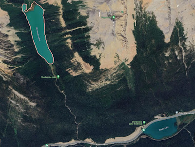
It was a smoky morning -- doesn't Canada have a lot of wildfires? -- with clouds hinting at future rain. From the car park, this was the view of Wapta Lake.
The initial part of the trail climbs up, bearing west with occasional switchbacks. At one point, you can continue towards Sherbrooke or head right for a steeper climb up to Paget Lookout. Lots of people were on our route today.
Here's a panoramic sweep taken near the foot of the lake.
Zooming in towards (but not reaching) the head of Sherbrooke.
Joan and I continued along the trail, looking for a good sit spot. The clouds continued to gather, and we decided it was time to return. Despite nearby thunder, we had only light rain; Joan and I donned our rain gear at the Paget Lookout intersection. Then we drove down to Field and the Cathedral Mountain Lodge for our lodging and dinner. We felt like our trip had finally begun. Tomorrow -- Lake O'Hara!

Tuesday, August 23, 2022

Back to Canada (at last), Bow Valley Trail

The covid-induced pause in travel meant that Joan and I hadn't visited the Canadian Rockies in almost three years. We resolved to try again in 2022, and persevered through obstacles: Delta changed our schedule from Columbus to Calgary so drastically that we switched to United, and until the U.S. dropped its requirement for citizens to pass a covid test if returning by air (but not land or ferry), we had a backup plan to reach Calgary by driving to and from Toronto and flying between Toronto and Calgary. In the end, we flew to Calgary on United without any hitches or delays (departing Columbus at 6:00am), despite a warning that the Canadian customs terminals might not be "up."
 
In Calgary it was our first time renting a car from Enterprise, whose price quote was 1/4 that of Hertz and 1/2 that of Avis. We were thrilled to not wait in a check-in line, but be escorted to directly to our car and review all the necessary details (how big a scratch counts as damage, etc.) right there.
 
On our way to Canmore we stopped at the Barrier Lake Center to purchase bear spray and a Kananaskis Conservation pass, a new fee for vehicles parked in the area. There is no physical pass; the license number of your vehicle is entered in a database which the rangers can check as they patrol the parking areas.
 
Then we continued on to Banff to snag our physical Parks Canada passes (cheaper as two seniors rather than a family), and finally returned to Canmore, where we were staying with our friends and former B&B hosts Bob and Val. Canmore was originally a blackened, dirty coal mining town; the mines closed in 1979, and the town has recovered as a tourist and second-home destination. It's also sitting in the middle of a wildlife corridor, so grizzlies, black bears, and elk are not uncommon.
 
We fell into bed and slept for nine hours after a dinner at Rocky Mountain Flatbread and an evening walk north on the wide trail along the Bow River. That walk included seeing an osprey nest, a Franklin's ladyslipper, and a round-leaf orchid.
 
The next day's hike was south down the Bow Valley Trail / Trans Canada Trail. It was a sunny day and warm, with a high about 82°F, or 28°C, but the humidity was so much less than Ohio's!
After a breakfast at Uprising (wraps, pastries, good coffee) we crossed the bridge to the Trans Canada Trail and I paused to capture the Bow in full flood; spring came late in 2022 and the river was full of snow melt.
We were quickly greeted by a chipping sparrow.
This route is used by hikers, bikers, casual walkers, commuters, anyone and anybody. A look at the Bow from the edge.
The trail crossed a smaller stream.
Zooming in, a piece of wood looked much like the Loch Ness monster.
Soon the trail threaded between a housing development rising on the south side, and a woods on the north. Female elk were lying down in the woods, taking it easy in the shade and chewing their cud. The longer we looked, the more of them we saw. The cyclists zooming past, of course, saw nothing. They were also unlikely to hear the Swainson's thrush that we did.

The next stretch typifies the Canmore sprawl, with new developments springing up between the mountains and the river.
After a few minutes I took this photo looking back.
The road goes ever on ... to the cluster of development at the next highway exit.
Why is such an expansive meadow here?
It's reclaimed coal strip mine land, planted to have something there, and to prevent old mine tailings from eroding into nearby lands and rivers.

A side loop further along took us closer to the Bow through much less developed terrain. (Click on the image to enlarge.)
This tree will be carried away sooner rather than later.

After about three hours we turned around, when the trail entered a developed area. Along the way we'd seen numerous species of flowers. Here, a Lewis/blue/prairie (pick your common name) flax.
This is a vetch of some sort, but there are so many ...

This yellow clematis, a vine, is an invasive and considered a noxious weed. Pretty though.

How the crowds had increased by the afternoon on this sunny Tuesday! We saw various watercraft ... first, three males in a small inflatable raft towing a small inflatable circle -- imagine a doughnut three feet across -- paddling only with their hands. On the Bow in flood. Yikes!
Then, upright paddlers with paddles. And a coach.
By the time we reached Canmore, the crowds were out in full force, whether sunbathing, cycling, walking, or taking photos.

That evening we had dinner at Sauvage, a new restaurant since our last visit here. Sauvage offers 5, 7, and 10 course tasting dinners, both vegetarian and non-vegetarian. Wine pairings are also available. Recommended, but go hungry!

After today's warm-up, the next day's hike was more ambitious. Next post!

Wednesday, October 10, 2018

On the 2nd Day of Hiking (Windy Point)

Our next day's hike was also off the Bow Valley, in the Wind Ridge drainage, and like the previous day's hike a new trail for us. Parking was at the Mt. Lougheed Viewpoint. Joan and I were headed for Windy Point, on the dark ridge at right.
More aggressive hikes also begin here, such as Skogan Pass (17.6 km/10.9 mi round trip, 670 m/2200 ft height gain) and Centennial Ridge/Mt. Allan (11.1 km/6.9 mi one-way, 1441 m/4729 ft height gain).
The lower stretches of the trail were gently rolling, with several re-routes and replacement bridges due to the 2013 floods.
Some temporary signs. Joan enjoyed the artwork.
The equestrian route diverges for a while.
Don't go the old way.
This valley has a reputation for hosting grizzlies, so Joan and I were periodically calling "Yo Bear!" to warn any possible ursus arctos of our presence.

This new bridge had curiously offset boards forming the approach,
because it rests on a large downed tree trunk, 
an ingenious conservation of material.

After this bridge (one of a close-by pair) the uphill work began.
For a long time we were walking through the woods, keeping an eye out for wildlife, flora, and trail damage. After the sharp turn at the bottom center of this image, it was uphill all the way.
Some trail repairs were minimal, but good enough for the purpose.
Picture taken looking back, downhill.
After a couple of switchbacks and a short flat stretch the trail, littered with loose stones, lurched straight up the side of an open area. Joan and I were very glad to have our hiking poles, as the stones preferred to pretend they were ball bearings.

We neared the ridgeline, walking past a path beaten in the grass that departed from the main trail, and continued on. Wonderful views into the valley and the peaks beyond opened up, even with the wildfire haze. (Click on the image to enlarge.)
The trail ascended with the ridgeline, headed towards the high point of Wind Ridge.
That might have been our destination, but we'd read this in Gillean Daffern's Kananaskis Country Trail Guide, Vol. 3, regarding the first of several sandstone rockbands ahead: "This is the crux scramble. Starting is hard if you can't put your left foot where your left ear is. Get someone to give you a shove ..."

We decided that the beaten-grass path must have been the way to Windy Point, and turned around. It wasn't far to the viewpoint. Here we lunched.

The trip back down the main trail began with a hair-raising descent on the steep path to the bottom of the open area. I'm glad it wasn't any longer than it was.

Our return was largely uneventful until we were back in the rolling, creek-threaded country. I saw a spruce grouse emerge into the wide path.
Then another one!
They were fearless, slowly walking up the trail in our direction, bobbing and pecking for edibles. They didn't veer away from us until only a meter away.
Love those eyebrows.
Joan and I were well satisfied with the Windy Point hike, a good workout for our second day in the Rockies. That sandstone rockband on Wind Ridge ... another time? Maybe! Maybe.


Saturday, September 29, 2018

On the 1st Day of Hiking (Bow Valley)

The beginning of our September Canadian Rockies visit included a connection in Minneapolis (MSP), an airport in the midst of expansion. Here are a couple of through-the-glass photos.
New parking garage
This drilling machine dug by rotating the blades a few times, then removing the loosened dirt by raising the blades out of the hole, pivoting them to one side, and shaking. 

WestJet didn't hand out customs forms aboard the plane to Calgary, so we needed to fill them out on the spot at passport control. Then the automated kiosk couldn't read the form, so we had to go to a live agent. Entry didn't take long even with these minor frustrations.

Hertz wanted to "upgrade" us to an SUV, but we wanted a vehicle with a trunk, to keep luggage out of sight while parked at a trailhead. Hertz obliged with a Toyota Corolla, which was less expensive but had plenty of room for our two large duffels. We drove to Canadian Artisans Bed & Breakfast in Canmore -- spotting two elk in the driveway next door! -- and introduced Kristin, the Icelandic Pig, and Dart, the Poison Dart Frog, to Mr. Bear, our host.
Hi guys!
The next morning started with a short walk to the Canmore Farmer's Market (every Thursday), which was in various stages of being set up at 8:30. The berries from British Columbia are luscious, and Joan bought some blueberries. We also bought a meat sandwich and apple strudel at the German Baker to split later.

Stocked with lunch supplies, we were prepared for our first hike, on the Bow Corridor Link Trail. This trail links two sections of the Trans-Canada Trail; both hikers and mountain bikers are allowed.
This screenshot (click on the image to enlarge) captures the route Joan and I took, wherein 'P' marks the parking spot, at Heart Creek, 'V' marks the location of the Vault, an incomplete Cold War bunker, and 'C' indicates the intersection of the Bow Valley and McGillivray Canyon trails. Click on the image to enlarge.
The weather for this day and the next was a milder repeat of last year, warm in the afternoon and hazy from wildfire smoke.
A wide beginning.
Looking north: trees, highway, river, then the BayMag facility in Exshaw that processes magnesium oxide, mined both here and in Radium.
Joan spotted an osprey circling above the water, and we followed it through binoculars until we saw it crash into the river and emerge with a fish, with which it flew away.The following day's

The first part of the trail wound uneventfully until we had to choose whether to climb to the Vault steeply or with a couple of switchbacks. We went with the switchbacks, while a group of three people and one dog chose the steeper route. These would be the only people we'd see on the trail.
The geometry created a multi-point intersection.
Joan at the entrance to the Vault, where documents and financial records were intended to be stored against nuclear attack.
The graffiti changes regularly.
A couple of tunnels branched off once we were past the entrance,
Critters have been dragging in green leaves of the season.
but they didn't go far.
Joan and I left the Vault and continued west. On the way we encountered this mourning cloak butterfly, among others.
The trail narrowed, including stretches where cyclists couldn't pass a hiker without dismounting, and presented more vigorous ups and downs. We passed signs warning bikers of risky stretches, plus unmarked side trails, or trails demarcated only by a colored ribbon, and finally declared it lunchtime.

As we munched we decided that we'd recently passed the side trail for the McGillivray Creek chockstone, and should backtrack to find it. It wasn't far away, although completely unmarked. The first stretch of trail was a gentle grade through forest with frequent deadfall.
Extensive stone debris from the floods of 2013 has annexed the lower reaches of the creek.
As the canyon narrows timber and rock debris choke it, making following the trail above the creek the better choice, unless you're looking for a challenge. Joan and I followed it as it veered away from the creek and began to climb. After a while we became uncertain whether it was taking us to the distant peak instead of the canyon, and we turned back. Joan eventually found a steep footpath down into the canyon.
Joan explores the next bend.
Joan, in the lead, soon encountered pools of water and we decided to push no further. Looking at the left-hand side of the screenshot, we now see that we should have remained on the trail.
Next year we'll try again, starting from a parking area closer to the McGillivray trail. That should give us enough time to poke around and find the chockstone.

Our next hike would be a step up in effort, but not trail finding.