Showing posts with label canadian artisans. Show all posts

Sunday, July 19, 2020

Canada (2019) Part One

September 4th, 2019 saw Joan and me embark on an eagerly awaited trip to the Canadian Rockies. We rose at 3:30am for a 6:30 flight to Minneapolis, where we had a generous four-hour layover. Fortunately MSP is well laid out for walking and for opportunities to observe the airport expansion work.
There's still a lot of manual labor in the construction biz.
Hertz was running low on cars in Calgary and upgraded us to a Sonata. On arriving at Canadian Artisans Bed & Breakfast in Canmore we were shocked to see the empty lot across the gravel drive fenced off and dug up.
Val and Bob told us that the vacant lot had changed hands three times in the last fifteen years, but they had been given only two weeks notice that construction was to begin. Every tree was removed and the building will stretch to the minimum 5' setback from the property line. Ouch! What a crowding.

The next day was a Thursday, and the Canmore farmers market.
Love this sign.

We bought some luscious fruit -- fresh berries from British Columbia -- and, from a German-style bakery, lunch sandwiches. After gearing up we drove a short distance east for today's warm-up hike, sections of the West Wind Creek Loop. Parts of today's hike were repeats from last year, and some new.

The start has several creek crossings.
After a while the trail took a right turn and began to climb the ridge, but a lesser path split off shortly after the turn, taking us into new territory. More winding through the cool woods ensued, and then the land began to open up.
The ridge trail goes up to those green and beige peaks.
Joan and I meandered up the valley, encountering a wilson's warbler, mushrooms, and fall flowers -- asters, cinquefoil, paintbrush, and so forth.
At the end we even bushwhacked up the ridge for a few minutes along a sketchy route before thinking the better of it and returning to the meadow. Then it was time for the first half of lunch in a grove of trees.

We backtracked to the ridge trail and decided to climb as far as the first good view. The vista revealed the difference between the (relatively) low ridge we were ascending and the high mountains.
I couldn't resist fiddling with this photo via the Deep Dream Generator.
After the second half of lunch at this viewpoint we descended and returned to the car, happy with our exploration.

The next day, Sept. 6th, our goal to was to reach the Chockstone on McGillivray Creek, which had eluded us last year. We parked closer to the trailhead, and found the path that departs from the Trans-Canada Trail (renamed the Great Trail in 2016).
The trail remained in the woods above McGillivray Creek, whose stream bed is expanded and strewn with rock and other debris from the flood of 2013.
Many of the fallen trees that last year had created obstacles in our path were now cut in two parts, perhaps by the Lac Des Arcs Climbing School, which uses the creek walls for climbing exercises.
Rings on the rock wall.

The valley narrowed and the path, also shrinking, climbed more and more steeply to stay above the creek, demanding constant vigilance of pole and foot placement, rock steps, and roots. It leveled out -- on average -- and after a while corkscrewed down towards the channel bottom.
Large rocks were omnipresent, and grew huge as we ascended along the streambed: the heavy boulders dropped out of the flood first, smaller ones downstream.
Our steps forward became trickier and time-consuming; we wove from side to side to find a way forward, sometimes climbing up a scrap of bankside, always placing our feet and hands carefully. Wet rocks were treacherous and best avoided. After half an hour of this we reached the Chockstone.
Really, Joan, it's quite safe ...
The way beyond was daunting, filled with boulders taller than we were.
We decided this was far enough. Back at the parking area we met the first other hikers of the day, just starting out. Late starts seem not uncommon in Canada.

The 7th was a transition day. Joan and I were heading for Cathedral Mountain Lodge, a comfortable accommodation only a short drive away from the Lake O'Hara parking area, making it easy to catch the O'Hara morning bus. We picked up lunches at Storm Mountain Lodge, directly on our way to Boom Lake, today's hike. We were also checking out Storm Mountain as a place to stay next year.

Ready for a sunny Saturday excursion, we arrived at the parking area for Boom Lake, our first time.
The trail is wide and after an initial climb rather gentle.
Boom Lake is a family favorite because of the easy hiking. The last few hundred meters are rocky and uneven, but the stretch through the forest had no obstacles other than an occasional muddy patch or footbridge.

This panoramic shot of the lake suffers from prismatic stutters, because of the angle of the sun, but it's the best I have.
A couple dozen people -- mostly women -- had spread out along the rocky shore, boulder hopping to find a conducive sit-spot. Looking up the lake,
the ramparts are impressive. Joan and I found our own spot and had lunch. We heard a pika making its "eep!" call, and a bold chipmunk sniffed and nuzzled Joan's pant leg.

Shortly after leaving the lake we encountered an arriving Japanese family of four; a young boy struggled with a cart/wagon carrying various picnic supplies, including a pillow. It seemed quite incongruous. On the way back we met many inbound groups of two to six, usually with a dog or two, which ranged from small lapdogs to a mastiff -- all on leash, as they should be in the park. When we reached our car there were only one or two parking spaces left.

We had a good dinner and rest at Cathedral Mountain, although I managed to knock my clock/meditation-timer off the bedside table onto the floor. The electronics still worked but the LCD display was a cracked and unintelligible inkblot. And the darn thing isn't made any more. I had to improvise with my phone.

Well, tomorrow would mean Lake O'Hara, which can soothe many wounds.

Monday, October 15, 2018

On the 3rd Day of Hiking (Bow Summit)

Our third day of hiking was also a transit day. Joan and I departed Canmore and Canadian Artisans for Yoho National Park, to overnight at Cathedral Mountain Lodge. Here are Val and Joan as we say goodbye.
Also before leaving I took this snapshot of a small fabric bonsai with an origami crane. Clever and very effective. And low maintenance.
Our mid-day hike was to the Bow Summit Lookout. We had trod this path three years ago, but been frustrated with the views (and photography) due to the onset of showers. Today there were some light sprinkles in the morning, but the day remained dry.

At a few minutes past noon we searched for a place to park among the throngs at Peyto Lake, and of course paid a visit to its viewpoint. We must have heard a dozen languages today, because Peyto Lake has become a must-see destination.
The color, from glacial silt, never ceases to please.
Continuing on the paved path, Joan and I arrived at the point of departure for Bow Summit Lookout. 99% of the crowd didn't go this far.
Much of the trail was unremarkable, a moderate climb with one pair of switchbacks. There was a big dip close to the end, however, so we had a downhill/uphill combination both coming and going.
The valley and the rock formations made this a good place to spot pikas and marmots.
This marmot was enjoying a burst of sunshine. It was the only marmot we saw during our entire trip; many were already hibernating, or preparing to do so.
Beyond the location of the old fire lookout the trail becomes unofficial, a boot-beaten track that took us higher and to a southern view.
Joan and I continued to what we considered a good vantage point. Before sitting down for lunch I accidentally dislodged a rock that spun halfway down the mountainside before coming to a stop, hopping like a skipping stone. Watch your step!

It was a great place to munch and spend time. To the south the Icefields Parkway ran past the drive for Num-Ti-Ja lodge, on the shores of Bow Lake.
A zoom-in on the overflow parking there. Beyond the lake are trails to Bow Falls and even the Bow Hut.
Bow Summit acquired its name from being the highest point on the Icefields Parkway, and the highest for "a major highway" in Canada. This high point of the road was visible in the view to the north.
Above us, two young women had clambered up as far as the cliff face.
Photo taken with zoom.
Then it was time to hike back to the car and check in at Cathedral Mountain. The dip-and-climb looked like this on the return:
Our next day would see us returning to Lake O'Hara.

Saturday, September 29, 2018

On the 1st Day of Hiking (Bow Valley)

The beginning of our September Canadian Rockies visit included a connection in Minneapolis (MSP), an airport in the midst of expansion. Here are a couple of through-the-glass photos.
New parking garage
This drilling machine dug by rotating the blades a few times, then removing the loosened dirt by raising the blades out of the hole, pivoting them to one side, and shaking. 

WestJet didn't hand out customs forms aboard the plane to Calgary, so we needed to fill them out on the spot at passport control. Then the automated kiosk couldn't read the form, so we had to go to a live agent. Entry didn't take long even with these minor frustrations.

Hertz wanted to "upgrade" us to an SUV, but we wanted a vehicle with a trunk, to keep luggage out of sight while parked at a trailhead. Hertz obliged with a Toyota Corolla, which was less expensive but had plenty of room for our two large duffels. We drove to Canadian Artisans Bed & Breakfast in Canmore -- spotting two elk in the driveway next door! -- and introduced Kristin, the Icelandic Pig, and Dart, the Poison Dart Frog, to Mr. Bear, our host.
Hi guys!
The next morning started with a short walk to the Canmore Farmer's Market (every Thursday), which was in various stages of being set up at 8:30. The berries from British Columbia are luscious, and Joan bought some blueberries. We also bought a meat sandwich and apple strudel at the German Baker to split later.

Stocked with lunch supplies, we were prepared for our first hike, on the Bow Corridor Link Trail. This trail links two sections of the Trans-Canada Trail; both hikers and mountain bikers are allowed.
This screenshot (click on the image to enlarge) captures the route Joan and I took, wherein 'P' marks the parking spot, at Heart Creek, 'V' marks the location of the Vault, an incomplete Cold War bunker, and 'C' indicates the intersection of the Bow Valley and McGillivray Canyon trails. Click on the image to enlarge.
The weather for this day and the next was a milder repeat of last year, warm in the afternoon and hazy from wildfire smoke.
A wide beginning.
Looking north: trees, highway, river, then the BayMag facility in Exshaw that processes magnesium oxide, mined both here and in Radium.
Joan spotted an osprey circling above the water, and we followed it through binoculars until we saw it crash into the river and emerge with a fish, with which it flew away.The following day's

The first part of the trail wound uneventfully until we had to choose whether to climb to the Vault steeply or with a couple of switchbacks. We went with the switchbacks, while a group of three people and one dog chose the steeper route. These would be the only people we'd see on the trail.
The geometry created a multi-point intersection.
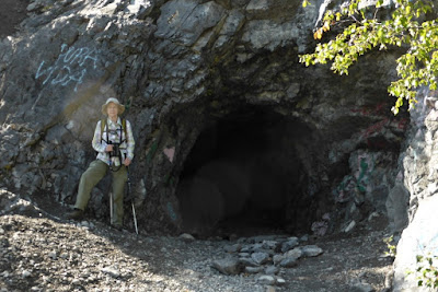
Joan at the entrance to the Vault, where documents and financial records were intended to be stored against nuclear attack.
The graffiti changes regularly.
A couple of tunnels branched off once we were past the entrance,
Critters have been dragging in green leaves of the season.
but they didn't go far.
Joan and I left the Vault and continued west. On the way we encountered this mourning cloak butterfly, among others.
The trail narrowed, including stretches where cyclists couldn't pass a hiker without dismounting, and presented more vigorous ups and downs. We passed signs warning bikers of risky stretches, plus unmarked side trails, or trails demarcated only by a colored ribbon, and finally declared it lunchtime.

As we munched we decided that we'd recently passed the side trail for the McGillivray Creek chockstone, and should backtrack to find it. It wasn't far away, although completely unmarked. The first stretch of trail was a gentle grade through forest with frequent deadfall.
Extensive stone debris from the floods of 2013 has annexed the lower reaches of the creek.
As the canyon narrows timber and rock debris choke it, making following the trail above the creek the better choice, unless you're looking for a challenge. Joan and I followed it as it veered away from the creek and began to climb. After a while we became uncertain whether it was taking us to the distant peak instead of the canyon, and we turned back. Joan eventually found a steep footpath down into the canyon.
Joan explores the next bend.
Joan, in the lead, soon encountered pools of water and we decided to push no further. Looking at the left-hand side of the screenshot, we now see that we should have remained on the trail.
Next year we'll try again, starting from a parking area closer to the McGillivray trail. That should give us enough time to poke around and find the chockstone.

Our next hike would be a step up in effort, but not trail finding.