Showing posts with label gillean daffern. Show all posts

Saturday, November 7, 2020

Canada (2019) Part Seven: Jumpingpound Summit and Beyond

Sunday, September 15 (2019). Joan and I started out at the Market of Pomeroy Kananaskis resort, buying breakfast sandwiches, lunch sandwiches, and two large cookies. The breakfast was consumed on the spot.

We departed for a hike to Jumpingpound Summit and beyond. The drive included, first, a drive on the unpaved Sibbald Trail, and then 16½ km on the "not for travel use" Powderface Trail. On this Sunday we didn't encounter any logging trucks, but it was mandatory to keep an eye out for oncoming traffic nonetheless. Today it was quiet. We were the first at the parking area for Jumpingpound, although another car quickly arrived. Its occupants embarked on the trail before we did.

The red circle is the parking area.

Soon after starting out Joan and I were passed by a fellow on a mountain bike, but we didn't encounter anyone else on the long series of switchbacks taking us up through the forested slopes of the mountain. A short spur partway up led us to a wooden bench and a view.

We marched on through the forest,

and finally reached the ridgeline, where the trees became smaller and sparser. Thoroughly warmed up, Joan and I removed our outer fleece jackets. The cold breeze was welcome. Our trail intersected a much longer north/south trail, and we headed north.
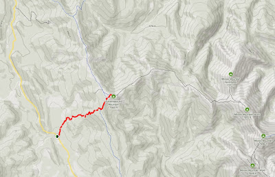
Map from parking area to Jumpingpound summit.
After a gentle, climbing walk we reached open ground and the trail to the summit departed to the right.
The view from the summit to the west, towards the valley we had driven down.
Joan and I decided, after some discussion, to continue along the visible but unofficial trail along a series of tops beyond the summit, rather than return to the longer Cox Hill trail -- more scenery per mile. Gillean Dafern's page on this route gave us the confidence to tackle these tops. This was the view ahead.
The route took us through thick woods and open meadows, but there was almost always a trail to follow.

We sat on the lee side of top #1 for a first lunch. Below to the left we had been seeing a mysterious site come into view, which we now realized was a wellpad (natural gas, built 1993, it turns out).

After lunch it was time to descend from top #1 and then ascend to top #2. The distances were not as great as they had appeared from Jumpingpound Summit. Partway up the next hill the trail disappeared into a treeless meadow, but the goal was in plain sight. At the top was a tall post.
It's a survey marker.
Along the way we had seen a wide variety of hardy plant species in the open spaces, eking out a living at ~7000 feet altitude and 51° north latitude. Some examples:
Red sedum/succulent probably not associated with the greenery.

Dried yellow rattle.

One of the many species of hawkweed.

From here we could see that reaching top #3 would involve much more elevation change and some road-walking,

Click on the image to enlarge.
so this was a good time to turn around. Soon we could see, through binoculars, new arrivals reaching the top of Jumpingpound Summit, including several groups with dogs. As we climbed back up Jumpingpound I took this photo looking back, with the trail we'd been on visible in the open areas.

We revisited the summit and then began the hike back down. On this Sunday there were plenty of late hikers coming up.
On our descent we stopped again at the viewpoint bench. (It always seems to be 2/3 of the way up when hiking up, and 2/3 of the day down when hiking down, a common illusion.) Another couple was there, and during our conversation we learned that their son is teaching at Ohio State. We taught them the obligatory call-and-response of "O-H", "I-O."

Joan and I had our second lunch there, each of us having half a sandwich that would otherwise go bad. Then it was back to the car and our hotel. Although we returned at 4:30 our room had not been serviced yet, and we needed to clean up before our dinner reservation time. I went downstairs to complain and received a promise to send someone right away. Half an hour later Joan went down and read them the riot act, and help then did arrive right away. They were understaffed and servicing vacated rooms before overstay ones -- not our problem!

A quick shower and an excellent dinner followed, lighter than yesterday's. Given the forecast of a chance of rain, we decided on the Kananaskis firetower as tomorrow's destination, leaving our primary goal this year, Upper Kananaskis Lake, for the day after.

Sunday, March 4, 2018

Smoke and Snow: Baldy Pass

Joan and I checked out of Cathedral Mountain Lodge and drove a short distance to the Siding Café, in Field, to pick up lunch supplies. They have great sandwiches and baked goods, but we discovered that after Labor Day the Siding doesn't open until 11. Oops.

At the Visitor's Center in Field Joan bought a couple of books, we picked up two Le Chocolatier bars, and we had a long chat with a warden from New Zealand about trail closures due to bear activity at Moraine Lake and Paradise Valley, the uses and misuses of GPS, and what constitutes an emergency-demanding rescue. Then it was off to Kananaskis Country.

Just east of Canmore and off the Trans-Canada there was a trail head and Mount Lougheed viewpoint which we'd never visited before. The mountain in the center is Lougheed.
We're looking almost due south from the end of the road, from the top of this map to the bottom:
Here's a zoom-in on the mountain, which tops out at 10,194 feet.
Signs described the history of the area and the role Sir James Lougheed played in therein.

We then drove to Highway 40 and the parking area for Baldy Pass, another hike that we've done once before but not since the 2013 floods. By satellite view, the route was thus,
and by map, like this.
The trail began on the far side of the highway, and after crossing, Joan and I were winding gently through woods.
The trail from the Wasootch Creek parking area joined us, and we approached Indian Creek.
 Almost there, and more stones were in the path.
Now the trail followed the rubble-filled creek. Sometimes we scrambled through the rocks following cairns, and sometimes the path had shifted to a stream bank.
As you can see, we had a lot of altitude still to gain.
In this stretch we met a guy (age 55) and his wife from Calgary ex Edmonton ex Ottawa. He was fresh off an unexpected heart attack and monitoring his heart rate as he hiked. Not long before the heart attack his doctor had said he was in great shape, and didn't need another physical for three years, but some measure (I forget which) had been 4.9 where 5.0 suggests intervention. Fortunately he survived this oversight and has been recovering well.

The trail continued to ascend. Watersheds on either side of the valley had violently contributed to the destruction lower down.
The route left the valley floor and metamorphosed into a rooty trail climbing steeply through the trees on the south flank of the valley. It was much shadier than the rock river we'd left behind, and the higher Joan and I went, the more common it was to cross snowy patches. We enjoyed occasional views of the ridgeline north of us.
The winds were blustery when we reached the cairn at the pass.
Here we met a couple with a white dog. They had planned their hike ahead of time, but somehow she needed to ask us, "what's the name of that mountain?" There's a place in the world for good paper maps, such as the Gem Trek series, and classic guide books, such as Gillean Daffern's.

Joan and I turned to the south and continued with a short climb, to the point where the trail leveled off and began to dip down into the next valley. There we sat down and lunched. This was the view back past the pass towards the north.
Descending down to the pass.
There is an unofficial trail beaten along the ridge rising to the north, and many hikers take advantage of it. We spotted the white dog couple there with our binoculars more than once.
I'm sure the view from anywhere along the top is grand.
Perhaps, if we revisit Baldy Pass in another few years, we'll give it a go.

Back in the woods, not far from the road, Joan and I spotted a trail camera we'd overlooked on the way out. From the University of Calgary.
A short drive later we checked in at the Delta Lodge Kananaskis, recently purchased by Marriott, extensively renovated, and reopened two months ago. There were oddities in the reorganized rooms, such as, no towel racks, and a common bathroom/closet door -- open it to the bathroom and you've closed the closet, and vice-versa. The staff was friendly and empowered to fix less structural problems, such as a sock left on the floor by a previous guest. The larger restaurant, the Fireweed Grill, was now dubbed the Forte, and its omnipresent mood music was classic 1960s pop ("One Fine Day") instead of disco, an improvement.

Joan and I ate well but spent a fitful night before rising for the next day's hike at Upper Kananaskis Lake.

Saturday, January 20, 2018

Smoke and Snow: Grotto Canyon

September 9th began with another chat with Val, Bob, and the Dutch couple also staying at Canadian Artisans. Joan and I picked up further lunch fixings on top of items (cheeses, cookies) Val had left for us and drove out to the Grotto Canyon trail head, arriving at 10:30. We had visited the canyon once before, prior to the 2013 floods.

The signs at the start. Today, all the dogs we saw were not on a leash. At least we weren't buzzed by a drone.

The first stretch of the trail passes just north of a BayMag MgO (magnesium oxide) plant.
Even before reaching the mouth of Grotto Canyon we passed a small wash that bore the scars of the floods.
And then a larger wash, but still not the big show.
Today was even smokier than yesterday. The wildfires, although not approaching Canmore, weren't that far away as the raven flies.
Joan and I reached a bench that overlooked the main outflow.
We scrambled down a boot-beaten path into the gravel meadow, and after heading uphill a short distance, I took this picture looking back.
Where the flood plain narrowed into the constricted canyon Joan and I were forced to clamber over a boulder. Then we saw the rock-filled creek bed, with no water in sight. It created a broad road here in the lower reaches.
The canyon quickly narrowed.
The walk to the waterfall was uneventful. Here are two photos of it from 2011:
Water was flowing today as well, even in the dry weather, so it's likely spring fed. Joan and I continued to the left, away from the waterfall,
and met a great surprise. A rock garden had sprouted after the flood! (Click on the image to enlarge.)
The fad of creating balancing rocks
and fanciful shapes, such as this rock person,
had caught on here.
The canyon doglegged to the right, and yet more rock assemblies presented themselves.
We passed a family busy adding more, one per person.
Joan and I continued up, and beyond the rock garden there were few other people around.

We passed this tree island. It's a non-lithic hoodoo, and who knows how much longer it will survive?
Grotto Canyon offers more challenging, or at least taller, rock climbing than Heart Creek.
Past the climbing wall the proportion of large boulders steadily increased -- the heaviest objects will fall out of a flood first. Joan and I would stop now and then to choose our route, around or on top of them. Now there were no other hikers.

We encountered our first pika of the trip. Yay!
The canyon goes as far as you care to take it.
We stopped for lunch, and saw our second pika.
And a moth visited us.
It was time to head back. All three rock climbers were on the cliff face now. Soon after passing them we met a couple from Mexico City. It was the husband's birthday, and he was having a great time. His wife was ready to turn around, even if it was his birthday, but we mentioned the climbers ahead, and she agreed to go that far. They had come to Canada in part to get away from Mexico City's awful air pollution, but today offered no change!

We saw the other side of the rock garden on the return.
After we passed the waterfall a raven flew overhead, close enough for us to hear the whooshing of its wing beats. Then, paying attention to the directions from Gillean Daffern's guidebook, we finally saw the ochre pictographs on the canyon wall for the first time in either this or the 2011 trip. They are easy to overlook if you're not searching for them. 
These pictographs -- symbols painted onto rock rather than carved into it -- are estimated to be 500 to 1,300 years old, so it's amazing that they have survived at all, especially because they are within reach of hikers. The presence of a Kokopelli, a flutist human figure, indicates a Hopi origin, confirming the story in The Book of Hopi of a clan that journeyed north to a land of ice and rock. The fronds on the head make me think this image may be the Kokopelli.
A line of figures.
A closeup of the largest/best-preserved figure.
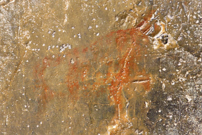
Bison.
An alternative proposal was that the local Stoney Indians visited the Hopi and brought the Kokopelli idea back with them.

This picture taken further down shows a log jam created by the flood.
Joan and I arrived back at the car well satisfied with all that we had seen. Given the flood, we hadn't expected much, and today was a good increment of effort over yesterday. On the way back to town we bought three chocolate bars at Le Chocolatier, a mandatory stop, for use in later days.