Day 9
On July 19th, 2023, Joan and I agreed, "Let's get a good hike in, but also have a bit of a recovery day." To that end, we decided to visit Lake McArthur, taking the Big Larches trail (Route 2) for the first leg, hoping to see some pikas or marmots there.First, we passed by the shores of Mary Lake.The Big Larches trail climbs a stone-and-root staircase along the edge of a rubble field, the accumulation of material that's fallen off Mount Schaffer.On this day, Joan and I didn't spot any pikas or marmots here. We reached Schaffer Lake and, bearing left, continued.
Out of curiosity, we visited the sign-up kiosk for the Odaray Grandview. The pass there is a wildlife corridor, and there are seasonal limits on the number of groups using the Odaray Highline trail. One group had already returned, and we chatted with them. The fourth and final group signed in ~10:30. Joan and I returned to the McArthur Highline trail, and saw a marmot family -- yay! Here's a youngster:And somebody's keeping an eye on him.A little over half an hour later, we arrived at Lake McArthur, and found a spot to sit for lunch.
As we ate, we saw a family of ptarmigans foraging. Here's a better panorama of the scene. Today the air was clear.
Another group was down by the lakeshore. That water is cold, by the way. Glacier melt!
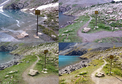
Photographers taking pictures of photographers.In this panorama, we can see a trail at far right.There's an intersection where a hiker can take the Low Level trail to return, rather than retracting their steps on the Highline, or go a short bit further around the lake.In a wet year, we've seen that sign with a couple of inches of water at its feet, and in a dry one, more shore exposed.
During our return, we spotted a pika either working diligently on its harvest, or on its lunch.He paused for a moment.The return from Lake McArthur first afforded us a view from above, rather than beside, Schaffer Lake.At this point in the hike, there were too many critters to keep track of. Basking, playing marmots. Foraging pikas. One pika, not six feet away, issued a loud, high-pitched warning call when a bald eagle flew overhead. A mom golden-eye duck and her sole remaining chick sheltered on a rock in the middle of Schaffer.From here, Joan and I took the trail down to the Elizabeth Parker hut. This route is boring at other times of the year, but today, it was full of flowers, ferns, butterflies, and moths. At the Le Relais camp store, we even bought O'Hara-themed T-shirts. Our hike today was less strenuous than yesterday's trek, but given the views and the wildlife, it was a winner.


