For the next day, September 3rd, Joan and I decided to hike up to Wiwaxy Gap. It's not a long climb, but a notoriously steep one, gaining about 500 meters (1600 feet) on the way up to 8300 feet. The trail to Wiwaxy splits off from the Lake O'Hara circuit trail early, before the Lake Oesa trail, when heading clockwise from the cabins.
After leaving the initial switchbacking up the sides of an erosion gully, you soon come to a pair of noble trees. It's a hard life up there, but they've held on. They've seen a lot.
We pay our respects each time we pass by.
Shortly thereafter you reach a ledge that has inspired a million photographs. I'm far from an ideal model, burdened with daypack, binoculars, and bear spray, but I took Joan's photo here last year, so now it's my turn to pose. Darn it.
Wiwaxy Gap is often windblown. Here, behind a windbreak of sorts, Joan is surveying the view, in the away-from-O'Hara direction.
Glacier-draped mountains rise on the far side of the Trans-Canada highway. Through binoculars we can just make out the Paget Lookout.
At 2530 meters (8300 feet) we are high enough, when looking towards All Souls' Prospect, to see the tips of mountain ranges beyond.
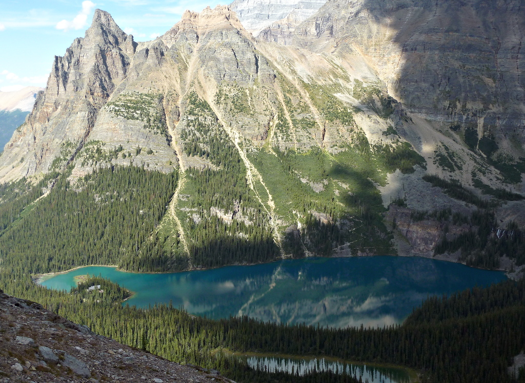
We continue by the Huber Ledges alpine route, which gradually descends to Lake Oesa. Shortly after starting out I took this picture looking back to Wiwaxy Gap.
This alpine route has generally good footing. It crosses several diminutive streams flowing down from the heights, complete with small waterfalls. Occasionally you step down from one ledge to the next, which requires attention to your footing. The geology has produced several tumbled rock outflows populated from various, differently colored higher strata.
Lake Oesa and its downstream offspring are clearly visible along much of the ledge. Note the small pond at the back of Lake Oesa, near the top of the image.
There are a few places along the ledges where you can find a good spot for lunching, and Joan and I took advantage of one. Afterwards we drew closer to Lake Oesa and it grew larger.
Here's a closeup of the pond in back. It's been shrinking during the summer, and vegetation is sprouting on the right.
We decided to walk back to that pond, following the right-hand side of Lake Oesa. At first there is an intermittent trail, but then it's just rock-hopping. This picture looks back across Lake Oesa when we're partway towards the pond. The prominent shape of Wiwaxy Peak dominates the skyline.
One attraction of trekking to the back of Lake Oesa is that you can look up towards Abbot Pass and Abbot Hut -- binoculars highly recommended. Somebody's up there, at 2922 meters (about 9,600 feet). Joan and I don't anticipate ever attempting that climb.
Beyond Abbot Pass is the Death Trap, Lower Victoria Glacier, and eventually Lake Louise.
We returned to Lake O'Hara by the Lake Oesa trail. Our first pause was to admire Lake Victoria.
On the initial segment of the return there's an abundant accompaniment of rushing waters.
These cones have been oozing sap that has coagulated and now masquerades as ice.
On our way back to our cabin I (finally!) took these photos of the lodge sign,
and the front of the lodge.
The next day Joan and I will tackle the hike to Last Larch Prospect, with lots of rock-hopping. Our feet will hurt by the end of it.
The next morning Joan and I set out for Lake McArthur. On our way we passed the Lake O'Hara dock, where the canoes were floating on air. Or at least on water like glass, with strategic lighting. The white flecks are small insects that have just hatched out of the lake.
There is a large swarm of insects in this photo, taken at Mary Lake, where we stopped for boot adjustment. They didn't bother us, nor the duck. The water so clear that we could watch the duck as it swam underwater.
I have blogged the particulars about the trail up to the lake, via Big Larches, the previous year. This time I didn't take any more photos until the lake first popped above the trees.
Closer up, Lake McArthur got even better.
We found a hillock with a view upon which to take our lunch, and soon were fending off the usual pesky ground squirrel. They are accustomed to begging or stealing from hikers.
People accumulate near the lakeshore.
Joan and I strolled on the lakeside trail until we reached the junction for the lower return trail.
Lake McArthur was higher last year, as you can see.
These mountains are stacks of colorful geological strata. Former sea beds!
It's good to stop when absorbing this or any other vista. Walking and gawking at the same time can lead to accidents.
From the very large to the very small, our focus changes. Here a pika has left harvested foliage in the trail, perhaps to dry?
A few minutes later we're granted a view down the valley of Cataract Creek.
The day is not over, and Joan and I are considering climbing to All Souls' Prospect. Looking ahead, we spot others ahead of us doing just that (click to enlarge).
This photo zooms in on our trailblazers.
After an hour we catch up to them; after a chat we push on while they continue taking a breather.
We reach the top! Not of the mountain, but of the trail. A hopeful squirrel is already here.
The other hikers join us at the prospect's marker cairn as I'm recording a panoramic sweep.
All Souls' Prospect is of course also a great vantage point for still photography. Here's Lake O'Hara.
A closeup of the peninsula with the lodge and cabins.
Looking south, to Opabin Lake, barely visible well above Lake Hungabee. The hiking trail is visible in both the left and right of the photo.
We returned via the Opabin Plateau, down the West Opabin trail, rather than retracing our steep ascent.
After dinner, as we walked back to our cabin, the setting sun put on a light show.
The reflections in Lake O'Hara were astonishing.
We paid another visit to the Sufi Bench, mentioned in at the end of the previous post. The angle of this photo nicely displays his painting and the glasswork star (click to enlarge).
Tomorrow Joan and I will tackle the huff-and-puff hike up to Wiwaxy Gap.
It was Sunday, September 1st, and Joan and I were excited, as we always are on the day we're going to Lake O'Hara. But first was breakfast where we were staying, at the Kicking Horse Lodge.
Saturday night must have been exciting for the staff. Or rough. Or both. We showed up for breakfast a few minutes after opening time, and the service was glacially slow. It was as if they were searching for a henhouse to raid for eggs. Joan and I always leave a margin of safety for getting to the Lake O'Hara parking area, and today we needed all of it. We arrived in good time -- but just a couple of minutes before the lodge bus. (You cannot drive to Lake O'Hara; instead, you must either walk/ski in or take a lodge or Parks Canada bus, depending on whether you are a lodge guest.)
As we rode the bus up, rental car left behind, our tensions began to melt away. We disembarked at the lodge office to check in and pick up prepacked trail lunches. Today we would hike up to Lake Oesa and cross the Yukness Ledges.
This photo was taken near the outlet where Lake O'Hara pours out into Cataract Creek. Lake Oesa is nestled at the foot of the high mountains on the left, and the Yukness Ledges trail crosses the flank of Yukness Mountain, center.
On a clear day such as today, there are stunning views in all directions as you gain altitude. Here we are looking west towards Mount Schaeffer.
I documented the hike up to Lake Oesa in detail in this 2012 post, so I'll jump to this view of the lake.
The scale is deceptive in the above photo; the lake is larger than it looks. Here's a video clip scanning it.
A researcher is on the lake, taking measurements.
Most people enjoy lingering here if the weather permits.
After eating our lunch we continued on to the Yukness Ledges trail. This view looks back to Lake Oesa just before it disappears.
Looking across to the Huber Ledges trail, which descends from Wiwaxy Gap to Lake Oesa, Joan and I spotted a group taking a rest break. They are just left of center, near the top. Click to enlarge, and look for the orange or turquoise jackets!
The Yukness Ledges route may not be the highest trail in the Lake O'Hara system, but it offers some of the best views of the lake and its surrounding mountains, including Odaray Mountain, upper center. Lake O'Hara is a stunning blue, while the much smaller and shallower Yukness Lake is tinted with green.
Here's a closer look. When walking past this lake on the way to or from Oesa you can easily study its bottom.
Now what's that up ahead? A hoary marmot on watch!
He's even more absorbed in the vista (and catching some sunshine) than we are.
Shortly thereafter we saw a creature that Joan and I had been hoping to see in each of the ten previous years and hadn't, a wolverine. This powerful animal was bounding along the terrace of Yukness Mountain below ours, moving quickly towards the Opabin Plateau. It was clearly nothing we had seen before; from its size, color, and gait we speculated that it was a wolverine. It traveled too fast for me to grab a picture. Later we saw a wolverine photo after a presentation at Le Relais, and confirmed that it was a wolverine. We mentioned this at the office and it turns out that there have been at least a dozen sightings this summer, so many that there is some concern that this wolverine is perhaps becoming too habituated to people!
The Yukness Ledges trail ends at the edge of the Opabin Plateau. Joan and I spotted some hikers heading up to Sleeping Poet's Pool as we looked back the way we had come. That trail can be very steep at times.
Heading along the plateau towards the descent to Lake O'Hara, we were greeted by yet another creature of the mountains, a pika. Eeeep! as they say.
My final picture from this day is Sufi Bench, built by Bob Knowlden, of Bob and Valerie at Canadian Artisans Bed and Breakfast. There is a fascinating, 33-year-old story behind this bench. From 1980 to 2002 the Sufi Movement in Canada (SMIC) met annually at Lake O'Hara, and at some point this bench was created and dedicated to the leader, Murshid Hidayat Inayat-Khan. Bob was an attendee at many of these retreats and had a strong hand in its construction.
Over the years the bench had deteriorated. Last year, 2012, at Bob's request we took rubbings of the central star, which was a wooden incision in the heart shape, which was itself carved into the bench's back. Bob, earlier in 2013, then rehabbed the bench, repainting the wooden surfaces and inserting a hand-made glass star inside the heart, using the dimensions from our rubbings. But he forgot to take a picture of the fruits of his work! We were glad to oblige him with pictures from several angles.
The evening included the reliably excellent dinner at the lodge, and we slept well in our cabin at 2115 meters (6900') altitude and 51° 21' N latitude.