The next day was introduced by bright sunshine. A short drive up Kicking Horse Pass took us to the Lake O'Hara parking area and bus stop. The fire road up to Lake O'Hara is forbidden to private vehicles, including bicycles; only the Parks Canada buses and the Lake O'Hara Lodge bus are allowed.
Bilingual signs at the bus stop shelter.
The lodge bus arrived and disgorged the departing guests and their luggage, then Joan and I joined the group headed up. We passed a surprising number of hikers walking the 11 km to Lake O'Hara.
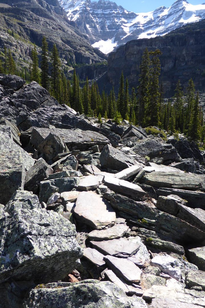
We checked in at the office, grabbed our trail lunches, and set off for Lake Oesa, always a good introduction to Lake O'Hara hiking. The Oesa trail split off from the the lakeside trail, at 7,000' altitude, and after several switchbacks that tested our legs began a more gradual climb that includes several boulder fields.
The trail passed by Yukness Lake, the first of several small lakes that precede Lake Oesa.
When the trail approached the gap between the Yukness and Huber ledges there were rock faces to tackle, but with steps,
courtesy of the legendary Lawrence Grassi.
A closeup of the plaque.
Soon we encountered a waterfall, the outflow from Victoria Lake (and ultimately of Lake Oesa).
Around the corner we stopped to observe a young raven bathing in a small pool. It ultimately flew off to a bluff on the other side of the stream, where it made an embarrassingly awkward landing.
There were plenty of flowers to observe; late July is late spring up here, "up" encompassing both latitude (51.35° N) and altitude (Lake Oesa is at 7438'). Joan and I saw beard's tongue, alpine mountainsorrel, fleabane, butterwort, and purple asters along this trail.
We decided to make a small loop from this point, rather than go directly to Lake Oesa. There is a cutoff trail that crosses in front of Victoria Lake and climbs up to join the Yukness Ledges trail. This map shows the loop we made.
First we gazed awhile at Victoria Lake.
Across the stream we went on stepping stones, then along a rock slab.
On the far side we had to climb among the boulders cast down by Yukness.
We could look out towards the Yukness Ledges,
and back down to Victoria Lake.
We reached the Yukness Ledges trail, and
turned towards Lake Oesa. We clambered up rock faces and through gaps between boulders, following the alpine blazes (two yellow stripes on a blue field). In this photo we're about to crest,
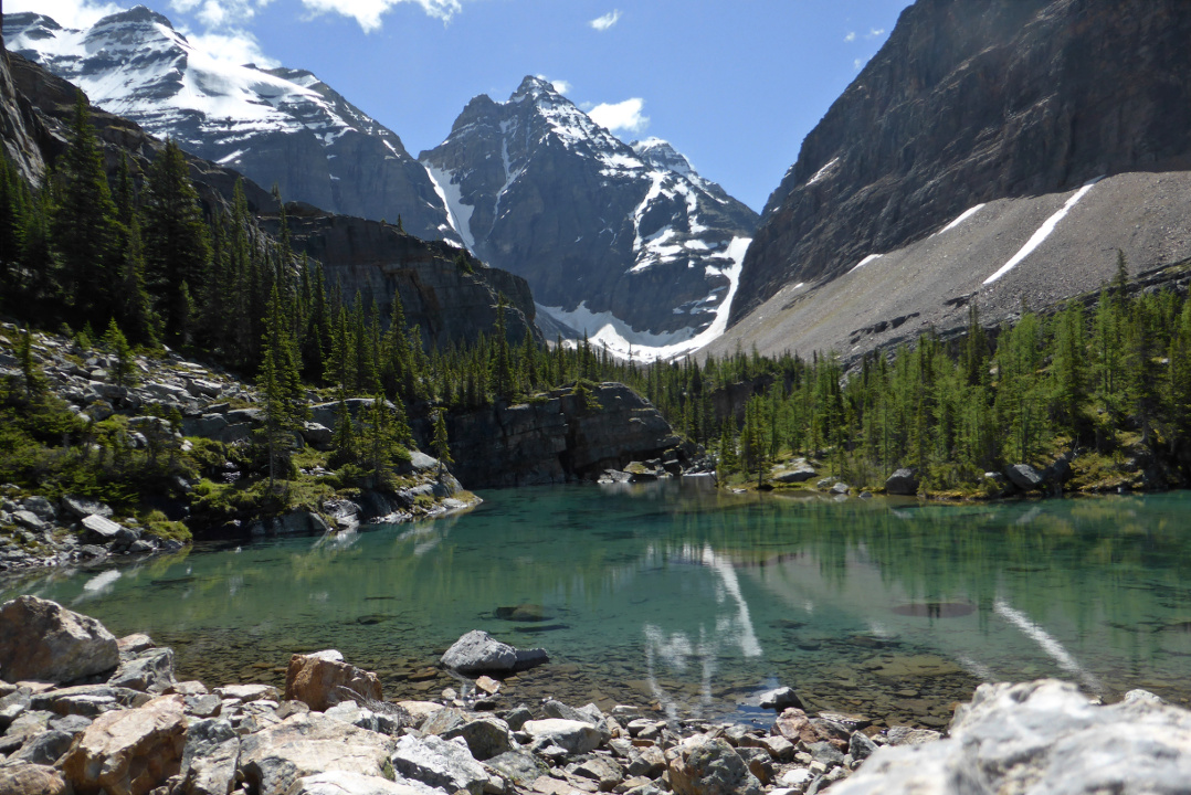
followed by our first glimpse of Lake Oesa.
Joan and I continued south towards Oesa. One more satellite lake, Lake Lefroy, appeared on our left. Lake Oesa is just behind that last bluff.
There were a few trailside chats along the way.
We reached Lake Oesa. Its wide expanse and rock slabs make it a favorite lunch stop. The small figures, center, provide a sense of scale. (Click on the image to enlarge.)
Joan and I were observed by gray-crowned rosy finches as we ate.
Clouds began to return, but our hike back to cabin #9 was pleasant and uneventful. Flowers hung from a basket on the porch.
Our pig companions for this trip, Margie and Rita, immediately headed for a front window.
Time to clean up and head for dinner! Tomorrow, Lake McArthur.
Today began with a long, luscious breakfast at Canadian Artisans shared with the newlyweds Lindsay and Andrew, from Queens. After a late getaway Joan and I drove past Banff, Lake Louise, and the Lake O'Hara parking area to the Sherbrooke Lake/Paget Lookout parking, just after the Great Divide Lodge.
We had taken both hikes before, Sherbrooke before I started blogging, possibly in 2007, and Paget Lookout in 2012. It was time to check out the lake again, albeit with an 11:30 start.
The trail began as a gentle-to-moderate but steady climb through the woods. (The Paget Lookout spur is steep.)
There were flowers everywhere, including blooming butterwort, bog orchid, twisted wintergreen, and more. We soon encountered a fellow from California (originally Philadelphia) headed towards us, and stopped expecting to exchange a few trail pleasantries. However he didn't want to stop talking. When other hikers needed to pass we took the opportunity to break away.
The weather was unsettled with hide-and-seek sunshine and drizzle. After the Paget Lookout trail split off we made a mild descent to the lake level.
I soon spotted this fellow, likely a Western Toad. (Note the long dorsal stripe.) It must be hard being an amphibian up north, with such a short summer season.
The trail along the east bank of the lake is rocky and rooty and doesn't offer a plethora of good lunch spots. Looking back we saw clouds gathering above Kicking Horse Pass and the Trans-Canada.
We reached the top of the lake, went a bit further, and then turned around. At one point Joan spotted 5 mountain goats on the slopes above the west shore.
Late in the hike we encountered a family of spruce grouse. Here's mama.
She had three youngsters, two in this photo.
We spent the night at the bottom of Kicking Horse Pass, at Cathedral Mountain Lodge. This is an angled view of the main office and restaurant.
The lodge is a mere fifteen minutes or so from the Lake O'Hara parking area, our goal for tomorrow, and where our rental car will get five nights' rest.
Our 2016 trip to the Canadian Rockies got off with a wild start. Packing on the final day before departure had gone well, but at 7 pm I got an email and a call from Capital One. There was an unusual charge that had been made -- was it mine? No it wasn't. The card had been hacked. And it was my one card that doesn't charge a fee for each international transaction.
We were leaving early in the morning for the airport, and we'd be in multiple locations where a replacement card couldn't be delivered. I didn't want the card chasing me across Canada, so I said to just mail the replacement to my home. Fortunately Joan's Capital One card had not been compromised, so we wouldn't get socked with fees. This time my wife would pay for everything!
There was enough time at the Minneapolis airport for us to enjoy a sit-down meal and do some wandering. We met a therapy dog, who had been working there since August 2015. It was shy of being leaned over, from too many laptops and other bags crashing into it, but eager to meet you when you come down to its level.
Our plane to Calgary pulled away from the gate on time but then stopped. An air-conditioning valve was stuck, and to access it the maintenance crew had to unload much of the luggage, and then the proper paperwork had to be filled out. Our plane resumed its flight after a 75 minute delay.
In Calgary our rental car was ready to pick up, for once, but we hit a traffic jam on the Bow Trail (the outerbelt or periphery freeway). There had been an accident on the Trans-Canada highway and we were caught in the end stage of its cleanup. Further down the Trans-Canada we saw a house burning.
Joan and I arrived at Canmore and the wonderful Canadian Artisans Bed and Breakfast at 5:30 local time, 7:30 Eastern time, after having risen at 3:30am. Our travel pigs, Rita and Margie, center and right, bonded instantly with Mr. Bear and Dr Little.
We took a brief stroll along the Bow River, five minutes behind Canadian Artisans. Joan spotted two osprey.
We also inspected the repair work on the abutments for the old railroad bridge, damaged by the floods of 2013.
Then we staggered back to Canadian Artisans for some sleep!
It took a while to hit the trail the next morning. First was the big breakfast that should not be missed, and catching up with Bob and Val, our hosts. Next was sandwich shopping for a trail lunch, and then purchasing bear spray at the Barrier Lake Visitors Center. After parking at Barrier Dam we started up the Prairie View trail at 10:45 when it was already sunny and hot.
Barrier Lake was low. In this panoramic shot, the two dots near the shore at center are people (click on the image to enlarge.)
Joan and I had taken this trail once before, five years ago. After having tackled the East End of Rundle two years running, we had opted for this, a less strenuous first-day hike.
Most of the trail as far as Prairie View is an old fire road. It passes the lakeshore trails and begins to switchback up the ridge.
It gets steeper.
Hikers share this route with mountain bikers; we met one woman pedaling up who, due to lack of time, soon had to turn around and head down.
There is an open bench before reaching Prairie View. The road across the lake is Highway 40, running down the Kananaskis valley.
Shortly after the bench there's a steep lurch up to the Prairie View, the rocky outcrop in the center of the photo.
A panorama from Prairie View.
A short distance from the edge -- we passed it coming up -- is an old radio reflector.
From the viewpoint we took a spur trail up the edge of the ridge to the Barrier Lake Lookout. The trail is braided in spots, but it's hard to get lost ... just head uphill.
This station is still in service, and we weren't supposed to pester the person who lives up here.
He or she could decide to chat with you, however, which happened on our earlier visit.
We enjoyed our sandwiches from a perch overlooking the Trans-Canada Highway and Exshaw, between us and Canmore. Exshaw hosts several resource processors, including a cement plant and a magnesium oxide plant.
Joan and I plunged downhill to the viewpoint, but rather than retracing our steps, we chose to continue further south, extending our hike into a loop, along the trail to Jewell Pass.
The rocky trail from the viewpoint dipped into the woods.
This section is a popular route with mountain bikers. The maps designate it as such, but it was still unnerving to discover that we often couldn't hear them coming unless they called out. No wonder mountain bikers can easily blunder into a surprised grizzly!
The path seemed to go on for a long time, perhaps because we were traversing a long green tunnel through the forest. Fortunately there were many more wildflowers to divert us than on the uphill slog.
Lower down, picking up Jewell Creek, we began to see the effects of the 2013 flood, such as this new bridge.
A few short switchbacks later we were looking up at the bridge.
The flood damage along the lower levels of Jewell Creek was so extensive that rather than move boulders to restore the original route, the trail had been relocated higher on the shoulder of the valley.
Joan and I began to hear the occasional rumble of thunder as we drew nearer to the lakeshore, quickening our steps. The trail back to the dam was not along the shore itself, but between it and the woods, dipping in and out of every fold and tributary ravine. The tramp grew tiresome, but the thunder moved on to the east, leaving us dry when we reached our car. It was a good first-day workout but it will be a while before we visit Jewell Pass again.
Tomorrow will be a transit day wherein we'll pick up a hike to Sherbrooke Lake.