Saturday, February 22, 2014

CR2013: Last Larch Prospect

Today's plan is to hike to Last Larch Prospect. The first portion of this trip visits Linda Lake and Cathedral Lakes, which we have hiked to several times; given the distance to Last Larch Prospect, we opted to hitch a ride on the morning lodge bus as far as the Linda Lake trail, which saves a couple of uninteresting kilometers on the way out.

Here we see the Parks Canada bus, not the lodge bus, but the photo illustrates the early post-breakfast light.
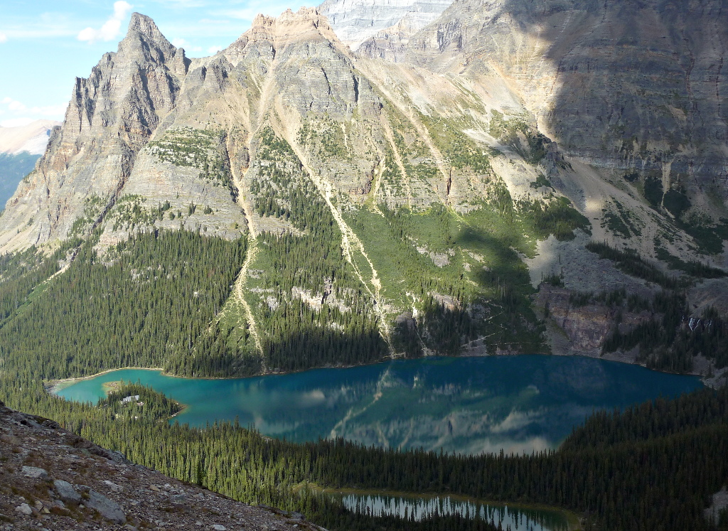
Looking in the other direction, towards Wiwaxy Peaks, there's a wonderful reflection.
This map section shows the Linda Lake trail near center top. Just remember to tell the bus driver that you want a drop-off there!

Less than half an hour after leaving the bus Joan and I crossed a footbridge, and every time I see this view, I am compelled to take a photo.
Here's a closer look at Odaray Mountain.
As you can see from the above map, after passing the Four Way Junction you soon arrive at the northeastern end of Linda Lake. Let's pull in another section of the map, covering the ground between Linda Lake and Last Larch Prospect.
We wind around the far side of Linda Lake and continue on the Duchesnay Basin trail, walking through a mixture of meadow and woods.
The trail crosses a footbridge at the head of Cathedral Lakes.
After a couple of meadows and woods the trail splits, ahead for Duchesnay Basin and right for Cathedral Basin/Prospect.
Joan and I head straight, and shortly thereafter we arrive at a long meadow. Here it is in 2013 ... an easy stroll ...
and here it was when we first visited in 2009. The guidebook claimed it was almost always dry, but it wasn't back then! This year we didn't have to bash along the shoreline.
The trail gradually climbs, with an occasional short but steep pitch over a hillock or moraine.
The last section is all uphill; this view is looking back.
The cairn in the center of this photo kept us on track until it was time to climb the slight ridge on the left. We're almost there!
The prospect is marked by a black-and-white striped pole. We ate our lunches here, and I discovered that I had picked up the wrong lunch bag part-way through the self-serve lunch-fixings line. Fortunately my sack had the famous Lake O'Hara cookies that I'd picked out, the most important part of the meal.

This video scans from the prospect, taking in the passes and peaks lining the Duchesnay Basin, plus the view back towards Lake O'Hara. At the end it zooms in on the black-and-white pole.

Joan and I decided to repeat our adventurous return route from 2009. Rather than retrace our steps, we headed further out and down to the left, in order to cross the creek at the foot of the mountains while it was still small. This off-trail option was described to us by Bruce, at Lake O'Hara lodge, back in 2009 as a possibility if time and energy permitted.

Here's our farewell glimpse of Last Larch Prospect.
As soon as we left the heights the land was cut by gullies curving down towards the creek. We picked one -- further up the basin than in 2009, when we had difficulty crossing the creek with dry feet -- and began working our way downhill. The sides of the gully rose.
We switched from side to side of the gully, sometimes abandoning one gully for another, through low spots. Lower down we also maneuvered along stream banks. Here is a photo from 2009.
We arrived at Duchesnay Creek and crossed it. After following the stream for a while I looked back towards the head of the basin.
This initial stretch, labelled Odaray Lakes Flat, is fine for walking, but the other side of the creek is choked with brush and mud. After we reached the Odaray Lakes the margin between the mountain's edge and the water disappeared. We were to begin rock-hopping.
For a while we could still follow Duchesnay Creek. 
The best way forward was to hop from rock to rock; otherwise you are smashing through dense woods or climbing the mountain's flanks. Sometimes the rocks are flat and cooperative, but most often you must calculate a path of small leaps on rocks of many shapes: ridges, indented tops, flat surfaces sloping the wrong way. Losing your footing could mean a nasty sprain or worse, miles from the road, so progress was slow. 

After the creek veered away we were left to traverse the Rutherford Moraines. Here is one section. More rocks.
After the first hundred meters rock-hopping became tiresome, for the feet as well as the mind. This route wasn't as exciting the second time around, somehow, and it seemed to go on forever. With each new turn hope rose in my heart that it would reveal Linda Lake, but it failed to do so time after time. When would the lake show up?

Finally Linda Lake appeared on the left, reachable by a short downhill stretch blissfully free of rocks. We were back on a trail! Linda Lake, beautiful as ever, demanded a pause.
The walk back to Lake O'Hara lay ahead of us. First, switchbacks down the Linda Lake Beeline trail, reaching the Morning Glory Lakes. Then, regaining the lost altitude on the Lower Morning Glory trail, with a couple of last opportunities to scan for marmots and pikas in modest rockfalls, followed by a 120ยบ turn and a long trudge through the viewless woods, which we had avoided in the morning with the bus drop-off. If hiking earlier in the year there is the possibility of at least hearing hermit or varied thrushes, but not today (September 4th). Joan and I felt great relief when we reached the Alpine Meadow pond and Elizabeth Parker Hut. Almost done!
Our cabin was a welcome sight. We were both footsore, and while glad to have visited the Last Larch Prospect again,  we find the off-trail return to Linda Lake has lost its charm. We are unlikely to repeat it.

Wednesday, February 12, 2014

CR2013: Wiwaxy Gap, Huber Ledges, Lake Oesa

For the next day, September 3rd, Joan and I decided to hike up to Wiwaxy Gap. It's not a long climb, but a notoriously steep one, gaining about 500 meters (1600 feet) on the way up to 8300 feet. The trail to Wiwaxy splits off from the Lake O'Hara circuit trail early, before the Lake Oesa trail, when heading clockwise from the cabins.
After leaving the initial switchbacking up the sides of an erosion gully, you soon come to a pair of noble trees. It's a hard life up there, but they've held on. They've seen a lot.
We pay our respects each time we pass by.
Shortly thereafter you reach a ledge that has inspired a million photographs. I'm far from an ideal model, burdened with daypack, binoculars, and bear spray, but I took Joan's photo here last year, so now it's my turn to pose. Darn it.
Wiwaxy Gap is often windblown. Here, behind a windbreak of sorts, Joan is surveying the view, in the away-from-O'Hara direction.
Glacier-draped mountains rise on the far side of the Trans-Canada highway. Through binoculars we can just make out the Paget Lookout.
At 2530 meters (8300 feet) we are high enough, when looking towards All Souls' Prospect, to see the tips of mountain ranges beyond.
We continue by the Huber Ledges alpine route, which gradually descends to Lake Oesa. Shortly after starting out I took this picture looking back to Wiwaxy Gap.
This alpine route has generally good footing. It crosses several diminutive streams flowing down from the heights, complete with small waterfalls. Occasionally you step down from one ledge to the next, which requires attention to your footing. The geology has produced several tumbled rock outflows populated from various, differently colored higher strata.
Lake Oesa and its downstream offspring are clearly visible along much of the ledge. Note the small pond at the back of Lake Oesa, near the top of the image.
There are a few places along the ledges where you can find a good spot for lunching, and Joan and I took advantage of one. Afterwards we drew closer to Lake Oesa and it grew larger.
Here's a closeup of the pond in back. It's been shrinking during the summer, and vegetation is sprouting on the right.
We decided to walk back to that pond, following the right-hand side of Lake Oesa. At first there is an intermittent trail, but then it's just rock-hopping. This picture looks back across Lake Oesa when we're partway towards the pond. The prominent shape of Wiwaxy Peak dominates the skyline.
One attraction of trekking to the back of Lake Oesa is that you can look up towards Abbot Pass and Abbot Hut -- binoculars highly recommended. Somebody's up there, at 2922 meters (about 9,600 feet). Joan and I don't anticipate ever attempting that climb.
Beyond Abbot Pass is the Death Trap, Lower Victoria Glacier, and eventually Lake Louise.

We returned to Lake O'Hara by the Lake Oesa trail. Our first pause was to admire Lake Victoria.
On the initial segment of the return there's an abundant accompaniment of rushing waters.
These cones have been oozing sap that has coagulated and now masquerades as ice.
On our way back to our cabin I (finally!) took these photos of the lodge sign,
and the front of the lodge.
The next day Joan and I will tackle the hike to Last Larch Prospect, with lots of rock-hopping. Our feet will hurt by the end of it.

Saturday, February 8, 2014

CR2013: Lake McArthur and All Souls Prospect

The next morning Joan and I set out for Lake McArthur. On our way we passed the Lake O'Hara dock, where the canoes were floating on air. Or at least on water like glass, with strategic lighting. The white flecks are small insects that have just hatched out of the lake.
There is a large swarm of insects in this photo, taken at Mary Lake, where we stopped for boot adjustment. They didn't bother us, nor the duck. The water so clear that we could watch the duck as it swam underwater.
I have blogged the particulars about the trail up to the lake, via Big Larches, the previous year. This time I didn't take any more photos until the lake first popped above the trees.

Closer up, Lake McArthur got even better.
We found a hillock with a view upon which to take our lunch, and soon were fending off the usual pesky ground squirrel. They are accustomed to begging or stealing from hikers.
People accumulate near the lakeshore.
Joan and I strolled on the lakeside trail until we reached the junction for the lower return trail.
Lake McArthur was higher last year, as you can see.
These mountains are stacks of colorful geological strata. Former sea beds!
It's good to stop when absorbing this or any other vista. Walking and gawking at the same time can lead to accidents.

From the very large to the very small, our focus changes. Here a pika has left harvested foliage in the trail, perhaps to dry?
A few minutes later we're granted a view down the valley of Cataract Creek.
The day is not over, and Joan and I are considering climbing to All Souls' Prospect. Looking ahead, we spot others ahead of us doing just that (click to enlarge).
This photo zooms in on our trailblazers.
After an hour we catch up to them; after a chat we push on while they continue taking a breather.
We reach the top! Not of the mountain, but of the trail. A hopeful squirrel is already here.

The other hikers join us at the prospect's marker cairn as I'm recording a panoramic sweep.


All Souls' Prospect is of course also a great vantage point for still photography. Here's Lake O'Hara.
A closeup of the peninsula with the lodge and cabins.
Looking south, to Opabin Lake, barely visible well above Lake Hungabee. The hiking trail is visible in both the left and right of the photo.
We returned via the Opabin Plateau, down the West Opabin trail, rather than retracing our steep ascent.

After dinner, as we walked back to our cabin, the setting sun put on a light show.
The reflections in Lake O'Hara were astonishing.
We paid another visit to the Sufi Bench, mentioned in at the end of the previous post. The angle of this photo nicely displays his painting and the glasswork star (click to enlarge).
Tomorrow Joan and I will tackle the huff-and-puff hike up to Wiwaxy Gap.