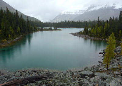
The next morning dawned with an unsteady light. I took this picture on the way to breakfast.
Not trusting the weather, Joan and I decided to hike up to the Opabin Plateau, which as you might see from this map, has not only a viewpoint above Lake O'Hara, but a series of lakes, woods, and rocky outcroppings to explore. If you go all the way to the back of the plateau you reach Opabin Lake.
View Larger Map
Here's the view from Opabin Prospect.
It became apparent that this would be a day with hourly weather changes. So far, just sprinkles. Moving up the plateau from the prospect, I caught this image of the west face of Yukness through the larches.
From one of the rocky outcroppings, a large lake close to the prospect.
I must zoom in on the larch on the right. It's far along in its golden transition.
Here is one of the cascades that feeds that lake.
Joan, the family spotter, called out "goats!" Yes, there were mountain goats on the flanks of Yukness. A family of four, although it was rare to see all four at once. If they appear quite small in the photo, remember that you should always take your binoculars on a hike, regardless of the weather or terrain.
By now the sprinkles were a drizzle, and threatened to become a shower. For Joan and me, it seems to be an "Opabin thing" to eat lunch in the rain. One year we walked for half an hour trying to find a spot that was less wet, and finally ate standing up. This year, as the squall reached its peak, Joan found a comfortable nook in the lee of some trees. Had the rain been coming down vertically, there would have been no shelter at all, but because it was arriving at a 45° angle the needles where we sat were dry. Taking gloves off to eat meant that we'd get cold, but we knew we would warm up again.
From the top of the escarpment that holds Lake Opabin, we could look back on our lunch spot -- the cluster of trees on the right rear of the larger lake -- and more. Much more.
You can see it was still chilly, and the ground was still damp.
Lake Opabin itself was a few feet lower than we'd ever seen it before. See how the vegetation stops before it reaches the water?
This rather uninspired photo looks towards the glacier and the pass that mark the end of the plateau. I'm standing as close to the edge of the water as I dared, not wanting to get sucked into mud. It was a novelty to be standing where, last year, I would have been in the lake.
Then the rain quit. Joan and I decided to head towards All Souls' Prospect one stage at a time. The weather was uncertain, and going to All Souls' would mean hiking down from the Prospect. This was something we did not relish. A couple of years ago we went down from Wiwaxy Gap, rather than up, and were satisfied that we had accomplished it, but steep descents are hard on the knees and raise our uneasiness more than a steep ascent. Here's a picture of hikers on All Souls' that I took on Day Two. The trail up from Opabin is to the left of the hikers, the way down is the face on the right.
The first stage was a pleasant wander down the west side of the plateau; the second was following the alpine trail blazes through fields of large boulders and then among huge slanted tables of stone, until we reached the scree slopes that truly separated the plateau from All Souls'. The weather was holding up, so we decided to go for it. There was one short stretch that was so steep that the footing was uncertain, and we planted our feet and walking sticks very carefully, but overall the trail was fine. Here's a view from the Prospect.
There is a faint rainbow in the center of the picture, but the camera didn't pick it up well, so don't feel bad if you don't see more than a fuzzy streak. The rainbow was indicative of the weather on the exposed point of the Prospect, which was blustery with occasional two-minute spatterings. In this image you can follow the valley all the way down to the Trans-Canada Highway.
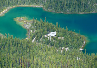
Next, a great perspective on the lodge and cabins.
And what's that behind and below, hidden from us as we walked above the ledges, but now open to view? A male mountain goat checking out two larches. A young one, for his horns are small. (Remember the rule: always take your binoculars with you.)
Clouds were moving in and it was time for us to get down, which we did successfully. It wasn't as bad as we had feared -- not uncommon -- but there were a couple of points where we were using our hands and climbing more than walking. Thankfully these were brief and manageable. Partway down I took a picture down into the Schaeffer Lake area, where you can see various trails winding.
We congratulated ourselves on turning a damp day into a great success. To wrap up Day Four, here's a picture of the anteroom in the lodge where jackets and wet shoes or boots are removed.
Day Five
The next day began with a steady light rain. Joan and I opted for a lower-altitude hike, to the lakes in the Duchesnay Basin. In the map below, Cathedral Lakes, Linda Lake, and Morning Glory Lakes are labeled. The white line on the right is the road up to Lake O'Hara (off the map to the bottom). To shorten an otherwise long day, we took the morning bus as far as the Linda Lake trailhead on the road, rather than starting from our cabin. We would need to walk all the way back, but we'd saved perhaps two miles of the less interesting territory close to the lodge and campgrounds.
View Larger Map
The rain prevented me from taking any pictures in the first few miles. Here's a colorful stand of larches along one arm of Linda Lake.
Further along, a crossroads with a very official-looking, bilingual sign.
We tramped past the Cathedral Lakes, towards Cathedral Basin and a viewpoint that precedes it. Joan and I had visited this viewpoint several years ago, in much warmer weather. However, the rocks and vegetation were so slick that after climbing perhaps halfway up, we decided to return to Cathedral Lake, where we had lunch and I took this picture.
Yesterday's rains and sprinkles had, at the higher elevations, fallen as snow. With today's warming daytime temperatures we had a running but intermittent show of what I call "mini-avalanches." Small bursts of snow would pour down a channel or crevice, large enough to see and to make noise, grabbing your attention. Not really enough snow to call an "avalanche," of course, but what else can you call it?
On our return we passed along the south shore of Linda Lake, and it was drizzling only lightly, enabling me to capture this view up the length of the lake.
We passed by the Morning Glory Lakes, and took the long, wooded, not so scenic path back to Lake O'Hara. But the excitement of the day was not yet over; as we drew close to Lake O'Hara (almost to the Parker Hut), we had a moment's view of a northern goshawk, our very first spotting of this magnificent raptor. The white stripe above the eyes is an unmistakable identification mark.
The return to our cabin was well-timed. The showers returned and turned to light snow before dinner. I took this picture from our front porch.
Day Six
From a Lake O'Hara point of view, there isn't much to report about day six. After breakfast I took this farewell photo and we took the morning bus down to our car.
I fired up the red Mustang and we pulled out, headed for Canmore and then Mount Engadine Lodge.


No comments:
Post a Comment
Comments may not appear immediately as they are moderated by the author to eliminate spam. Please, no commercial links!