Thursday, February 26, 2015

CR2014: Centennial Ridge Trail

August 1st brought us our final and biggest hike of this visit to the Canadian Rockies, the Centennial Ridge Trail. We rose early and ate in our room, our breakfast having been stashed in the mini-fridge the day before.

Joan and I first drove downhill from the Delta Lodge to the Ribbon Creek Day Use parking area, altitude we must make up on foot. After starting on the trail we encountered this sign.
The first stretch of the trail is broad and crosses and follows various old roads that lead to the Mine Scar, the site of an old open-pit coal mine that operated until 1952. Many of these lower-altitude trails show damage from the June 2013 floods.
The path grew steeper and we steadily gained altitude until the grassy sweep of the replanted strip mine opened up in front.
And we continued up. In favored spots flowers were blooming.
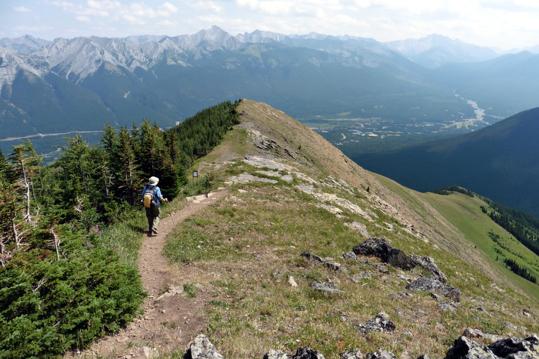
Moisture from heavy showers the evening before has generated low clouds this morning. Here, we look back after half an hour of switchback climbing through the coal scar meadows. The top of Mount Kidd, right, sports a grey wreath.
And we continued climbing. Eventually the meadows faded and the terrain became rockier.
Joan and I passed through sections where the trail was more of a route through rocky outcrops than a path. Eventually we broke out onto the beginnings of Olympic Summit, the odd name for a long, gently rising ridgeline that includes remote weather monitoring equipment.
Here is some of the gear.
Further on, there is a trail camera. Smile!
It was time for a chocolate bar, and our first sit of the hike. To the northwest, the last bump of Olympic Summit provided the foreground for rising clouds and mists.
The Centennial Ridge trail continues along the distant ridgeline.
Fortified by our chocolate, we continued to the high point of Olympic Summit and gazed across. The Ribbon Creek valley is on the far left, and the Memorial Lakes are just left of center.
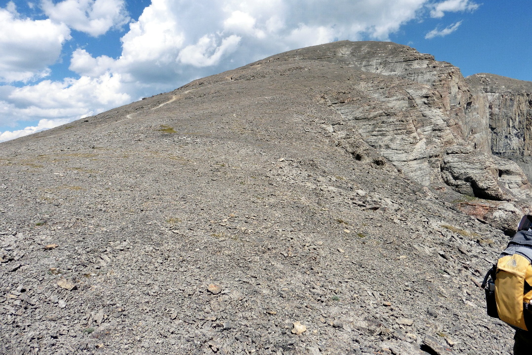
Our guidebook says that many people climb this far and then turn around, and emphasizes that this is a mistake. The trail stretches on towards Mount Allan, 10,860', still in the clouds.
Five minutes down the trail we encountered a guardian.
The trail descended (boo) and then began climbing again, weaving amongst the rocks.
The trail moved to the west side of the ridgeline and we entered the Rock Garden, a compelling reason to hike beyond the Olympic Summit. Mount Allan stubbornly held onto its clouds.
This is the view back towards Olympic Summit.
A plaque located five minutes on explains the origins of the trail.
The geology here has preserved a line of harder rock, tilted almost vertical by tectonic collisions. This line has eroded into a marvelous set of teeth.
It's difficult to comprehend the scale unless you're standing there.
This pika was wondering what we were up to.
I could have easily spent an hour here, photographing the stones from different angles and in different light.
And these.
Even up here, flowers take root in the stony soil, including dwarf larkspur and alpine forget-me-not.
We also saw a hoary marmot dashing about on these slopes.

Beyond the rock garden there's a short stretch of route-finding through rocks, which I'll show on the return journey, and then more trail. Joan and I reached a saddle in the ridgeline before the final climb to Mount Allan, looked at our watches, and decided to lunch and turn around. I've marked up this Google Maps image to show the trail parking, right, and our saddle. Mount Allan is in the upper left corner.
I took this panoramic shot from the saddle, looking west. Our entry route is on the extreme left, and the way to Mount Allan, finally out of the clouds, is on the right.
Here's a closer look at the route to the summit. Joan and I were tempted, oh we were tempted, to go on. But time was short at our hiking speed, and there was a lot of knee-pounding downhill to come. Reaching the saddle wasn't too shabby for a couple living in Ohio.
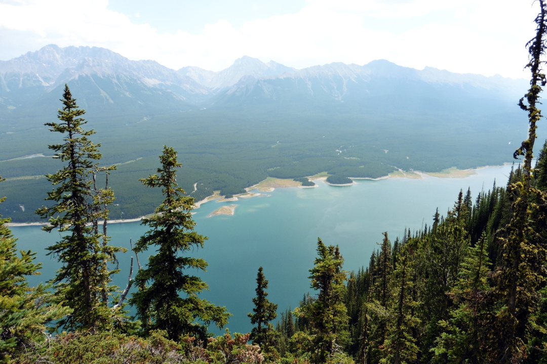
A full zoom with the camera captured this image of one of the Memorial Lakes, far across the valley.
We began to retrace our steps. This red flower caught my eye; it turns out to the ledge stonecrop, or Rhodiola integrifolia.
Approaching the rock garden again, this time from the north.
This rock wall slowed us on our way up. We briefly tried the east side, but it quickly broke into a pathless jumble. Here, Joan is approaching the point on the west side where we found the best way up and down. There was another point where down would have been easy, but back up problematic.
I paused for a panoramic view when we returned to the top of Olympic Summit. The clouds have lifted and the light is now behind me as I gaze down the ridgeline of the "summit."
After a few minutes hiking down the ridgeline we spotted a horned lark.
At the end of the ridge the path dove down various rock faces, and then opened up again.
We were walking through a study plot. Joan and I had also seen this sign when first entering the coal scar meadow.
We paused on some rocks here for a final snack break.
The fireweed still had some lovely blooms.
Here is a clear view of the trail through the coal scar meadow. We were glad for our trekking poles; it's even more precipitous than it looks.
My final photo of this hike shows a butterfly checking us out.
After a long, footsore tromp down the final segments we returned to the parking area. In particular, Joan's big toe had been troubling her for the last part of the descent. Intellectually we appreciated the correctness of our decision to turn about at the saddle, as much as our hearts would have enjoyed the view from Mount Allan.

Thursday, February 19, 2015

CR2014: Not the Day We Planned

On July 31st Joan and I drove from Delta Lodge Kananaskis to tackle the Wasootch Ridge hike. But we hadn't even reached the highway when the TPMS (Tire Management System) went off again, just like yesterday morning.

This meant that we didn't have a very slow leak that had taken two weeks, since renting the car, to trigger the TPMS. We had a new leak that took fewer than 24 hours to raise the alarm. Joan and I were heading for a day-long hike whose trailhead might very well have no cell service. We turned around. The receptionist at the Delta Lodge was helpful and gave us a pass for the underground parking garage, where there was an air hose. On arrival we saw that the hose had no pressure gauge. A maintenance guy showed me how to use the hose (not necessary) but had no idea where there might be a pressure gauge (usually necessary). I gave the tire a shot and Joan and I returned to our room to sort things out.

Joan began by using her Verizon prepaid cellphone to call Hertz, the rental agency. Or, she tried to. When she turned it on she received two text messages welcoming her to Telus, a Canadian wireless carrier, but she couldn't place a call out. She could call customer service, but that connected her to Telus, not Verizon. All other calls yielded a fast busy signal. I could call her from my T-Mobile prepaid phone, roaming with Rogers Wireless, but she couldn't call. This blow shattered our already shaky relationship with Verizon, which will be the subject of another post.

The Hertz help line, reached via the T-Mobile phone, wasn't helpful at first. She told us that if we had an auto club membership we could have them come out and change the tire for the "doughnut" spare, at our expense. Or she could have Hertz come do it, again at our expense. Such a shame we hadn't paid for 24 road service, she said. Argh. We weren't going to ride a doughnut spare on the mountain roads and all the way back to Calgary.

The closest Hertz agency was in Banff, the agent reported, but it was in a hotel and therefore must be very small and probably couldn't help us. Well, give us the number, please. And what is the hotel? The Fairmont Banff Springs, a high-end resort hotel with hundreds of rooms, boutique shopping, and a huge conference center. We smiled. The odds were good.

We called, and Kane answered. He had a car in the same category as ours that was to be turned in at 2:00, and we said we'd be over asap to turn in the damaged-windshield and leaking-tire car.

The first structure of the Fairmont hotel sits on one side of a large traffic circle,
opposite the conference center.
The entrance to the Hertz agency is just beyond the circle. Kane was very helpful with the paperwork for the current rental car, and then it was time to wait for the 2:00 return car. Joan and I explored the shops in the hotel, and then walked a while down the Spray River Loop trail. There we saw glimpses of an elk,
and noshed on the snacks we'd brought with us. We returned to Kane at the appointed time.

The 2:00 car hadn't been returned yet. We waited a few minutes while Kane worked with a customer that wanted to rent a car one-way to Toronto, a very expensive proposition. Then our turn arrived, and Kane gave us a low-mileage Toyota Camry. That car came with an annoying Hertz NeverLost GPS that would loudly announce "updating" at random intervals, but we were happy for a solid car.

Joan and I can't say enough about Kane's helpfulness, friendliness, and energy level. I was confident that he was a caffeine addict, but no, he said, he didn't touch the stuff. When the Hertz office closed at 4:00 he had some time off before starting his second job as a night accountant at the Fairmont!

The drive back to Delta Lodge Kananaskis in the Camry was pleasant and uneventful (except for the NeverLost). At dinner that evening we reflected on the day and realized that perhaps having a non-hiking day (it's hard to call it a rest day) was a good thing, for tomorrow we would tackle the Centennial Ridge Trail, the highest maintained trail in the Canadian Rockies.

Tonight there was a prerequisite for the Centennial Ridge attempt: food. The Delta Lodge Kananaskis restaurant and deli schedules do not cater to hikers who wish to make an early start, or grab a trail lunch the night before, so we had to stock up on snacks from the deli before it closed and stash them in the pocket refrigerator in our room.

Tomorrow would be the renowned relentless climb towards Mount Allen. The round trip is rated at 10 hours, so we'll see how far we can go before reaching a turnaround time, as with our earlier hike on the Windtower.

Wednesday, February 18, 2015

CR2014: Mount Indefatigable

On July 30th Joan and I awoke to see a red crossbill outside our window. The unusual beak (click on the photo to enlarge) allows it to pry seeds out of the cones.
We said our goodbyes at Mount Engadine Lodge, and spotted a morning moose across the meadow. We drove south towards the Kananaskis Lakes area, and Mount Indefatigable in particular. But just a few miles down the road there was a "Ting!" -- from the TPMS (Tire Pressure Monitoring System). A tire was low.

We pulled over and inspected. Visually nothing seemed wrong, so not having a true flat, Joan and I returned to Engadine and enlisted Riley's help. He hauled out the lodge's air compressor but had difficulty finding his tire gauge. Our rental car had an owner's manual but no tire gauge. (In the past we've even had a rental car with no spare, no manual, nothing on hand when we got a flat.) Then he found a gauge and we identified the low tire: driver's side rear. After Riley topped off all the tires, I consulted the manual and reset the TPMS, and then we were on our way. Thanks, Riley!

We left our car at the parking area between the upper and lower Kananaskis Lakes. Mount Indefatigable is in the background; our intention is to hike as far as the shoulder on the right for the view, not to try for the summit on the left.
We crossed the earthen dam to the other side of Upper Kananaskis Lake.
The drums and lumber in the lower left were in the process of being collected and taken away.

The Indefatigable Trail was and is popular, but it has been offically decommissioned, including the removal of viewpoint benches. Why?
The Park is very polite about it: "We request that you consider not hiking ..." But Joan and I wanted to do this just once, having heard much about it over the years from other hikers. I had bear spray, and we were prepared to turn around if we saw or heard a bear.

The route starts as a broad, needle-strewn trail but soon narrows and climbs amongst rocky outcrops near the edge of the mountain. Because the trail is decommissioned, it is no longer maintained, and has become braided with uncertain footing in places. The first viewpoint no longer has the Wendy Elekes Memorial Bench, but the view is still great, encompassing much of both the upper and lower lakes.

The trail continued to climb, and reached a fork where the route to the peak heads left. We continued a quarter-mile on the level to the final viewpoint, where we had our lunch. The trees here have grown up to obscure parts of the view, but I took a photo looking northeast,
and one looking southeast.
As we ate our lunch we also kept our eyes on a hawk soaring on the mountain breezes.
On our way back down, we paused at a meadow not far from the top, and I took another panoramic photo.
Clouds are gathering to take a vote on an afternoon thunderstorm.

Zooming in, the camera captured the parking area where we started.

Just a few steps beyond the meadow we encountered a blue grouse, hiding in the shade under a tree. His strategy was to hold absolutely still.
He looked big to us, bigger than the ruffed grouse we'd seen in the past. It turns out that the blue (lately subdivided into dusky vs. sooty) is the second largest grouse in North America, after the sage grouse.

Joan and I continued our descent, passing a few more people headed up. There were scattered drops of rain as we reached our car, but the thunderstorm convened at a different location.

We checked in at the Delta Lodge Kananaskis, now the Kananaskis Mountain Lodge, where they offered us an upgrade to an air-conditioned room with continental breakfast for a modest-enough fee that we accepted it.

Joan and I plan to tackle Wasootch Ridge tomorrow.

Saturday, February 14, 2015

CR2014: West Wind Pass and Windtower

July 30th started with a cold breakfast buffet, then a hot breakfast buffet, and then a lunch fixings buffet at Mount Engadine Lodge. It wasn't an early start when Joan and I set out to hike West Wind Pass and on to the Windtower. Or at least as far as we could go, given our launch time. We agreed on an approximate turn-around deadline of 1:30.

Many of the guidebooks refer to a parking lot on the west side of the road. It doesn't exist any more after the floods of June 2013, so we parked off the east berm of the road. The trail to West Wind Pass begins at the level of a creek, which is now filled with rubble.
The route fluctuates between flat and steeply uphill, with the creek further and further below you on the right. The trail splits into braids from time to time, but we made it up to the pass without getting lost. Here's the view to the east from West Wind Pass.
At least two other groups preceded us to West Wind. One was from Yakima, Washington.
To the right looms the Windtower. Its geometry is similar to that of the nearby Ha Ling: a sheer face to the east and north, but a slope to the west.
The route to the top of Windtower takes you south, gently rising, with occasional rock ledges to climb over. Then it takes a sharp left turn and climbs steeply through scree to a saddle, after which is the final bump of the Windtower. Let's look at an image again; click to enlarge. On the far slope there are at least half a dozen trails heading south, but they gradually combine. It can be confusing, even with a guidebook in hand, but if you keep heading south and, if presented with a choice, uphill, you'll arrive at the clearly defined sharp left.
This photo looks back to the pass at an early stage of our Windtower effort.
The trail became more difficult when it headed steeply huff-and-puff uphill to the saddle. It's full of loose scree, and sometimes I spent a moment pondering which route for the next fifty yards offered the best footing. This photo was taken from our lunch stop, where the trail has a green patch and temporarily is less vertical.
This was our view of the onward trail. You can make out that there is a saddle to be reached before the final push to the top.
Joan and I reached the saddle, and looked at our watches. We wouldn't summit Windtower, not this time. Here is the view to the east.
This was our view towards the top.
And here's the stunning view to the west, including the Windtower on the right.

The clock said it was turnaround time, and I didn't feel like arguing, even though the peak was issuing its siren song. The scree-filled path turned out to be easier footing going down than up; in places it was like walking on crusty snow. On the final approach to West Wind Pass we bushwhacked from one path to a better one, but being lost was out of the question with the pass visible in front of us.

Barreling down from the pass I took a wrong braid and after a while Joan halted my headlong rush. We backtracked a short distance (uphill) and then crossed over to the correct path, arriving at our rental car in decent time but tired and hot. To make it to the top of Windtower on some future hike, we would need to make arrangements at Mount Engadine Lodge for an earlier start. And I'd pack a couple of extra energy bars.

As we drove back to Engadine a convoy of three TransAlta utility trucks passed us in the other direction. They kicked up a stone that smacked our windshield at the level of my forehead, leaving concentric rings of fractured glass between two and three inches across. Thank God for safety glass! This was annoying, as well as scary, but we had dealt once before with windshield replacement in a Canadian rental car, so it wasn't intimidating.

Back at Engadine, in the evening light, the mountains were spectacular.
The other guests were admiring them as well.
Later on, it was moose time at the mud wallow, as it is almost every day.
The sun disappeared behind Tent Ridge, but continued to shine on the clouds.
Here is a two-moose photo, one on extreme left and one on the right.

Tomorrow would be an eventful transit day with another new hike.

Wednesday, February 11, 2015

CR2014: Arnica Lake, Mount Engadine Lodge

July 28th was a transit day; we drove from Yoho National Park in British Columbia to Mount Engadine Lodge, in the Spray Valley Provincial Park, Alberta. On the way we took a detour on Highway 93, south to the parking area for the hike to Arnica Lake. This snapshot from Google Maps shows the parking area in the upper left, and Arnica in lower right.
Unfortunately, the trail first descends to the level of Vista Lake before commencing a relentless climb up the flanks of Storm Mountain. This early view of the trail doesn't yet reveal Vista Lake.
Along this stretch there were several towering concretions/agglomerations, looking like wanna-be hoodoos. We were also buzzed by a hummingbird near this location.
The trail bent to the left, continuously descending, and Vista Lake grew closer.
This shot was taken from the lake's outlet. As the Copelands' book Don't Waste Your Time in the Canadian Rockies notes, it's an odd name for a lake at the bottom of a viewless fold.
After forty minutes of steady climbing we had gained enough altitude to look back at the parking area. The trees are young, regrowth after the 1968 Vermilion Pass fire. Our bodies were throwing off copious amounts of heat from the uphill slog, so being in the sun wasn't as pleasant as it ought to have been.
Towards the top of the climb we left the burn area, and the trees became much larger and taller, a wonderful development. Our pigs were relieved when we arrived at the shores of Arnica Lake.
It was a beautiful spot to take lunch. A light breeze helped keep the bugs away, mostly, and dry out our sweat-soaked shirts.
This was the turnaround point of our day hike. Overnight backpackers continue on to Twin Lakes and a popular campground. We didn't encounter any other hikers on this trail, however, until after starting our return.

When we broke out into the burn area I took another panoramic photo. The horizontal white streak is the cut for Highway 93.
Vista Lake was still a long way down.
This panoramic shot of Vista Lake was taken after beginning the ascent to the parking area.
Joan and I arrived back at the rental car tired and hot, but pleased with our first visit to Arnica Lake, overlooked until this twelfth visit to the Canadian Rockies. It's well situated for a travel day from Yoho to Mount Engadine Lodge.

At the lodge we met Riley and Mallory, the new innkeepers, and settled in. After dinner the sun slid behind the mountains, shadowing the meadow behind the lodge,
and half an hour after that, the famous Engadine moose began to show up at the mud hole. They slurp up the muddy water for its mineral content.
I also captured a photo of this year-old male moose; check out the knobbly little antlers he's growing.
Tomorrow, Joan and I will tackle a truly aggressive hike.