Showing posts with label centennial ridge trail. Show all posts

Saturday, February 22, 2025

Canada 2024: Let's try that again

On Sunday, July 7, 2024, Joan and I drove to the Lougheed Parking area to tackle the Centennial Ridge trail again. Two years ago our goal had been to climb above the treeline for the spectacular views, but our effort had been cut short by rain. Now we'd try again. Although we arrived at this parking area 15 minutes earlier than for yesterday's Heart Creek hike, it was jammed, and we had to park on the side of the road leading to the parking. Well, it was a Sunday.
No place to park here ...
There are several intersections in the beginning, including those for West Wind Pass and Skogan Pass, but we followed the signs for the Centennial Trail. (Click on any image to enlarge.) The green circles note the parking area and our "decision point" on the trek.
Here's a photo of the map at the beginning of the trail. With less clutter, the circles are easier to see.
As with yesterday's hike, we soon encountered flowers. This year had seen a late spring, so July was still bountiful. Today had more varieties than yesterday because of the much greater altitude gain. Here is a red baneberry, early in its season.
For a while the path led us gently up a wide trail beside the creek that, like so many others, had flooded disastrously in 2018.
We spotted a female bufflehead duck and her two ducklings working upstream.
There's a stretch where it's just an easy walk.
It won't last long.
More flowers ... here, a blue clematis.
The uphill slog began, still on a wide horse-riding route from the past. The terrain became dryer. A few faster hikers passed us. Then, there was a peek-a-boo view across the valley towards West Wind.
Here's a red elderberry, but we're too early for the berries!
Now we peeked at the ridgeline south of Mount Pigeon.
Click on the image above, and at the left of the ridgeline, you'll see a small structure. This photo from Google Maps gives me confidence in my ID.
On we climbed, with frequent stops to catch our breath. Continued effort gave us a peek at the Bow Valley and Canmore.
And close to the ground, an Alpine forget-me-not.
Joan and I passed the spot where we'd been forced to turn around two years ago, and kept going as the old road turned into a hiking path, which narrowed as we went. Then we hit a meadow beside a seasonal creek gully.
The gully was dry.
An interesting closeup.
From here we received our best view of the day.
The path then dove into the woods again. We continued for more minutes, perturbed that we had never gained the open ground promised by the map.
That's a 2200 meter altitude line, or 7218 feet.
And now it showed us dropping down three or so contour lines before regaining the lost height, and didn't promise open ground for a while yet. The afternoon was ticking on. Joan and I agreed that it was time to turn around. We did spot more flowers on the way down, including this "Pretty Shooting Star."
 
And a calypso orchid!
Downhill had its own challenges with steepness, surfaces, and fatigue, but we returned without mishap. Thank goodness for hiking poles! Joan and I reached our car a tick before 4:00 pm, footsore but satisfied with our effort, given that we gained ~2350 feet in altitude and it was only our second day of hiking. And the flora was fabulous.
 
A final odd note before we left was that I had to push forward as well as down on the Versa's trunk lid for it to latch.

Wednesday, February 19, 2025

Canada 2024: A Busy Start

On July 5th, 2024, Joan and I began our trip to the Canadian Rockies with an early United flight (6:45am). Our connection to Calgary out of Houston United was delayed because, after we'd boarded, the crew discovered that this international flight was the plane's first flight of the day, and a security sweep was required, forcing us all to de-board, wait, and reboard. Still, this was much better than the previous year, when United canceled our booked flight after everyone boarded and got us there a day late.
 
A group of twenty or so from Houston were flying to Calgary to observe and study that city's famous "Calgary Stampede," a multi-day collection of events including rodeos, concerts, etc. They were having a jolly time, although one woman had the flight crew scurrying to find her fancy cowgirl hat -- in the back of a bin above her seat. The front of the plane was entertained, that's for sure.
 
We had to put our foot down at the Enterprise car rental, for they kept offering us an SUV, and we kept insisting that we wanted a car with a trunk. Why? Several times we would be taking a day hike while traveling from one lodge to the next. We did not want our luggage to be visible to anyone in the parking area looking for a profitable vehicle to break into. Finally they found a Nissan Versa, although the car hadn't been washed yet. We took it. Heading west on the Trans-Canada, we stopped at the Kananaskis Visitor's Center to purchase bear spray and a two-day "Conservation Pass," required to park in Kananaskis and the Bow Valley, before reaching our hotel in Canmore. It had been a very long day and we collapsed into bed after dinner.
 
The next morning, July 6th -- a Saturday -- Joan and I drove a short distance east to the parking area for the Heart Creek Trail, arriving at 9:45, which is not bad for a first day. (Click on any image to enlarge.)
The trail meandered to the northeast for a short while.
Taking advantage of a sunny Saturday, families, family groups, and their dogs were out in force. On this stretch flowers were also plentiful, including these longtube twinflowers.
The trail bent 90° and began to wander up the gorge that Heart Creek has cut between Heart Mountain and Mount McGillivray. The 2013 floods scoured this narrow valley.
The trail has been reconstructed but wanders from side to side as the new topography allows. The sheer faces have always been popular for wall climbing.
We continued upstream. I took this photo twenty minutes before reaching the end of the trail.
We reached the choke point of the 2013 flood.
The rock wall and its narrow channel.
Joan inspects.
As I mentioned, family groups were out in force today; this destination, with its pools of water and rocks for sitting, was where they clustered.
On our way back I took this photo of a young lady practicing her "free climbing" -- a friend stands by belaying a rope for protection, but the climber (halfway up) ascends using only natural rock holds.
Joan and I finished the return to the parking area. We continued to the west, towards the Heart Creek Vault, a tunnel carved into Mt. McGillivray's limestone, intended (at first) to store essential documents against nuclear attack. Along this stretch we encountered wood lilies,
yellow salsify,
and a foraging least chipmunk.
Closer to the vault, this web of roots caught my eye.
The bright day was growing hot. Finally, we reached the entrance to the vault.
It's pitch black inside. Joan's headlamp was bright, but mine, an older model (and perhaps with a weaker battery?), was barely adequate for me to shuffle forward carefully. I neglected to take any photos (my camera does have a flash!), but there are images in this blog post from 2018. We snacked in a shady grove nearby, wandered happily a bit further west on the Trans-Canada trail, and then began our return to the car. On the way we admired this spotted saxifrage.
Our day had been quite full. The next day would be more challenging: seeing just how far we could manage on a route that had frustrated us in 2022, climbing the Centennial Ridge trail from the north.

Friday, August 26, 2022

Back to Canada, Centennial Trail

Joan and I began July 13th by revisiting the Uprising bakery in Canmore for breakfast, where we had a long chat with the greeter/order-taker/coffee-maker, Carolina, from the Czech Republic. Then we geared up for our "assault" on the Centennial Ridge Trail, starting at the northern end (many writeups start at the southern end.) Click on the image to enlarge.
Joan and I both knew we were not in shape to get as far as Mt. Allan; our goal was to get above the treeline for some inspiring views before we turned around. It would also be a great training hike, all uphill on the way out.

The view from the parking area. We will be hiking off the left side of this image; the high peak in the center of this image is Mount Lougheed. The weather was promising.
With the late spring, many flowers were still in bloom, including this blue columbine.
The initial segments of the trail had been damaged, or gave views of damage, from the floods of 2013.
Parts of the route are old horse trails, wider than a footpath.
With lots of greenery and no vistas for the first several miles, we did not dash along, but took time to inspect flowers and critters.
A bashful blue clematis ...
After the first mile the trail became incredibly steep, climbing the spine of the ridge. We paused frequently to get oxygen back into our muscles. And, at each curve in the path, one of us would yell out "Yo, bear!" to advertise the approach of humans.
 
More flood damage.
And a calypso orchid!
The birds were avoiding my camera, but we heard both the varied thrush and Swainson's thrush.
 
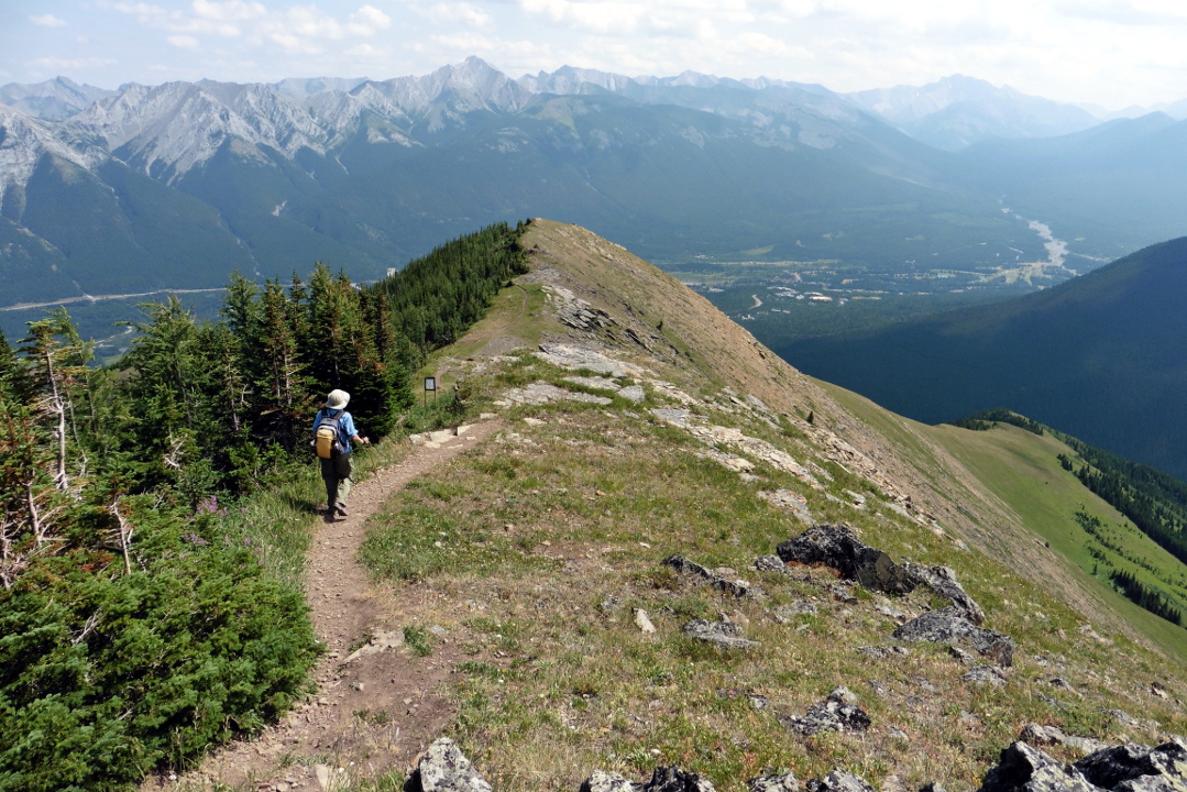
We kept climbing. Eventually, still in the woods, we could catch glimpses of Pilot's Knob to the east.
Stubbornly, the treeline kept refusing to appear. Clouds began to pile up to the west. We heard some rumbles -- perhaps they were passing jets? No, distant thunder. Still, we hadn't reached the treeline yet, and we pushed on.
 
It became clear that wet weather was moving in on our right, but not on our left. Would it hit us?
Joan and I started making agreements -- we'll go to the next switchback, the next corner, and re-evaluate. We must be close to the treeline. Finally we conceded defeat, and put on our rain gear just as showers hit us, binoculars and camera stowed away. We turned around and began our descent.

The rain let up for a while. We stopped at one of the few sites where there was a flat spot next to the trail, and saw that others had been there before us; a log was conveniently located for sitting, and charred embers marked a small campfire.

We were enjoying lunch in this cozy spot when we heard voices, the first in hours. Then two trail runners, skinny men in skimpy outfits, appeared, headed downhill. Then a third came along, and seeing us, started in our direction until he realized his mistake and turned around. Startled, we deduced that these guys must have started at the southern end, run up from Ribbon Creek to Mt. Allan, and been up above the treeline during the lightning and rain. (There had been unbroken spider webs across the trail on the way up, so they couldn't have started from the northern end before we did.) Yikes!
 
Down and down we continued, hard work on the knees and shins. Then, more thunder! The last third of the return was a walk in steady light to moderate rain all the way back to the car. As we drove back towards Canmore, the rain stopped, and then the pavement was suddenly dry. Back at Bob and Val's, they said it hadn't rained there at all. Mountain weather!
 
Joan and I cleaned up in time for dinner at Crazy Weed, where the limited staff was running at full speed to keep up. An early highlight was the labneh appetizer -- honey roasted eggplant, golden raisins, walnuts, dill, mint, zaatar & lemon, served with warm flatbread. We barely had room for the Thai chicken (Ben) or Chef's curry (Joan).

The next day would not be so strenuous.

Thursday, February 26, 2015

CR2014: Centennial Ridge Trail

August 1st brought us our final and biggest hike of this visit to the Canadian Rockies, the Centennial Ridge Trail. We rose early and ate in our room, our breakfast having been stashed in the mini-fridge the day before.

Joan and I first drove downhill from the Delta Lodge to the Ribbon Creek Day Use parking area, altitude we must make up on foot. After starting on the trail we encountered this sign.
The first stretch of the trail is broad and crosses and follows various old roads that lead to the Mine Scar, the site of an old open-pit coal mine that operated until 1952. Many of these lower-altitude trails show damage from the June 2013 floods.
The path grew steeper and we steadily gained altitude until the grassy sweep of the replanted strip mine opened up in front.
And we continued up. In favored spots flowers were blooming.
Moisture from heavy showers the evening before has generated low clouds this morning. Here, we look back after half an hour of switchback climbing through the coal scar meadows. The top of Mount Kidd, right, sports a grey wreath.
And we continued climbing. Eventually the meadows faded and the terrain became rockier.


Joan and I passed through sections where the trail was more of a route through rocky outcrops than a path. Eventually we broke out onto the beginnings of Olympic Summit, the odd name for a long, gently rising ridgeline that includes remote weather monitoring equipment.
Here is some of the gear.
Further on, there is a trail camera. Smile!
It was time for a chocolate bar, and our first sit of the hike. To the northwest, the last bump of Olympic Summit provided the foreground for rising clouds and mists.
The Centennial Ridge trail continues along the distant ridgeline.
Fortified by our chocolate, we continued to the high point of Olympic Summit and gazed across. The Ribbon Creek valley is on the far left, and the Memorial Lakes are just left of center.
Our guidebook says that many people climb this far and then turn around, and emphasizes that this is a mistake. The trail stretches on towards Mount Allan, 10,860', still in the clouds.
Five minutes down the trail we encountered a guardian.
The trail descended (boo) and then began climbing again, weaving amongst the rocks.
The trail moved to the west side of the ridgeline and we entered the Rock Garden, a compelling reason to hike beyond the Olympic Summit. Mount Allan stubbornly held onto its clouds.
This is the view back towards Olympic Summit.
A plaque located five minutes on explains the origins of the trail.
The geology here has preserved a line of harder rock, tilted almost vertical by tectonic collisions. This line has eroded into a marvelous set of teeth.
It's difficult to comprehend the scale unless you're standing there.
This pika was wondering what we were up to.
I could have easily spent an hour here, photographing the stones from different angles and in different light.
And these.
Even up here, flowers take root in the stony soil, including dwarf larkspur and alpine forget-me-not.
We also saw a hoary marmot dashing about on these slopes.

Beyond the rock garden there's a short stretch of route-finding through rocks, which I'll show on the return journey, and then more trail. Joan and I reached a saddle in the ridgeline before the final climb to Mount Allan, looked at our watches, and decided to lunch and turn around. I've marked up this Google Maps image to show the trail parking, right, and our saddle. Mount Allan is in the upper left corner.
I took this panoramic shot from the saddle, looking west. Our entry route is on the extreme left, and the way to Mount Allan, finally out of the clouds, is on the right.
Here's a closer look at the route to the summit. Joan and I were tempted, oh we were tempted, to go on. But time was short at our hiking speed, and there was a lot of knee-pounding downhill to come. Reaching the saddle wasn't too shabby for a couple living in Ohio.
An account from the accomplished hiking blogger Barry, a Calgary native who did reach the summit, is here.

A full zoom with the camera captured this image of one of the Memorial Lakes, far across the valley.
We began to retrace our steps. This red flower caught my eye; it turns out to the ledge stonecrop, or Rhodiola integrifolia.
Approaching the rock garden again, this time from the north.
This rock wall slowed us on our way up. We briefly tried the east side, but it quickly broke into a pathless jumble. Here, Joan is approaching the point on the west side where we found the best way up and down. There was another point where down would have been easy, but back up problematic.
I paused for a panoramic view when we returned to the top of Olympic Summit. The clouds have lifted and the light is now behind me as I gaze down the ridgeline of the "summit."
After a few minutes hiking down the ridgeline we spotted a horned lark.
At the end of the ridge the path dove down various rock faces, and then opened up again.
We were walking through a study plot. Joan and I had also seen this sign when first entering the coal scar meadow.
We paused on some rocks here for a final snack break.
The fireweed still had some lovely blooms.
Here is a clear view of the trail through the coal scar meadow. We were glad for our trekking poles; it's even more precipitous than it looks.
My final photo of this hike shows a butterfly checking us out.
After a long, footsore tromp down the final segments we returned to the parking area. In particular, Joan's big toe had been troubling her for the last part of the descent. Intellectually we appreciated the correctness of our decision to turn about at the saddle, as much as our hearts would have enjoyed the view from Mount Allan.