CR2011: At Lake O'Hara, Opabin Prospect and All Souls Prospect
We decided that a good place to begin our first day of hiking at Lake O'Hara would be Opabin Prospect. Then, based on how the weather was developing, we might stride further.
We chose the west trail for climbing to the Plateau. It's somewhat steeper than the east trail, but the east trail isn't as interesting, with lots of switchbacks in the woods. The initial portion of the west trail also heads through a forested area.
After passing close by Mary Lake, the trail breaks out of the woods as it enters the valley between the Opabin Plateau and Schäffer Ridge. Clinging to the side of the Plateau, it continues to climb.
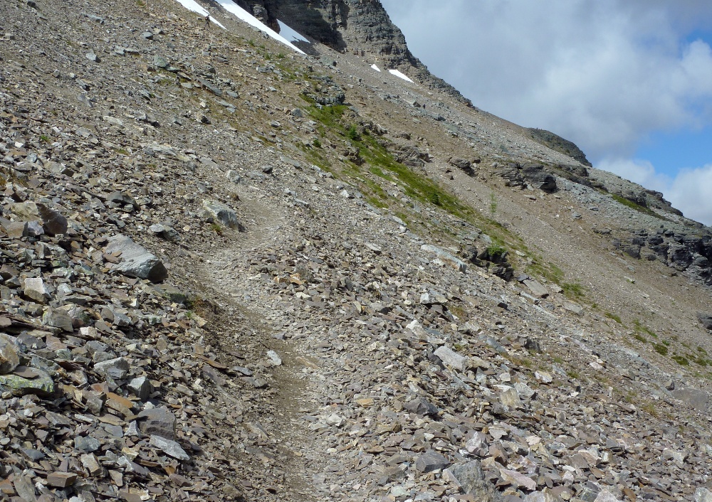
As with many trails, as this one approaches the gap it steepens and begins switchbacks. In this picture it almost looks as if the trail ends at the base of the cliff.
As soon as it reverses direction, the view opens up.
The moisture, which disappears beneath the rocks lower down, supports a wide swath of low greenery as we approach the lip of the plateau.
In the next picture we have crossed onto the plateau, but the trail still rises. In short order choices present themselves; first, the route to All Souls Prospect splits off to the right, and then the trail to the Opabin Prospect splits off to the left. If you continue straight, you will head deeper into the plateau.
We headed directly for the prospect, and after a short climb, we were weaving towards the edge along a much flatter trail.
Walking out on large rock blocks, hopping over the occasional petite crevasse, we reach the viewpoint.
The two lakes at far left are really just one, Mary Lake. The lodge and cabins are in the peninsula that pokes into Lake O'Hara near its far end.
We continued a short distance into the plateau, to an overlook that has a splendid view of the Cascade Lakes and, beyond, Yukness Mountain.
The rocky protuberance at right marks the beginning of the Opabin Highline trail, which offers a third way to explore the plateau in addition to the east and west trails.
The weather was holding up, so Joan and I decided to journey over to All Souls Prospect. The next picture shows the west trail descending to the junction for All Souls. You might be able to make out the small brown sign in the center of the image (click to enlarge).
The way to All Souls is an alpine route. That means that the trail can be steeper, narrower, and less visible than the regular routes. Blazes are painted on rocks to guide the hiker when the way is not clear, two yellow bars on a blue background. Joan and I call them Route 11 signs. In this next picture there is a blaze on the large rock in center top.
Sometimes the way may be easy, but blazes are still used to prevent wandering off the route.
As shown in the pictures above, the first stages of hiking from the Opabin Plateau to All Souls Prospect involve a rocky staircase, followed by picking your way through a flatter area. Once the flanks and scree slopes of Schäffer Ridge are reached, the terrain is vastly different.
The footing on most of the trail is OK, once you become accustomed to walking through and sometimes on the rocks. However, there is one short stretch where the route veers steeply uphill, and your foot must be planted carefully to avoid slipping. We found walking sticks very useful!
The view out towards Lake O'Hara and beyond provides a handy excuse to stop and catch your breath. This trail does not permit walking and gawking at the same time.
We trudged on, and the prospect drew closer. Occasionally people would pass us going the other way.
Then we were at the prospect.
We had been on the lee side of the ridge, and as we drew closer to the top, the wind began to bite. In the picture above, my hat is jammed onto my head, the gloves are on, and the rain jacket, serving as a windbreaker, is zipped tightly over my fleece jacket. The binoculars are underneath the rain jacket.
You've seen several pictures looking back to Lake O'Hara in this post, so I will spare you any more. This next image is looking down in the other direction, where the trail plunges from the prospect to Schäffer Lake. This stretch of the trail has one or two spots where both legs and both arms are engaged in holding onto rocks, but thankfully these are brief.
We began hiking down. It was too cold and windy to have lunch at the viewpoint; finding a spot partway down that was sheltered by rocks, we took a quick lunch. I was relieved to put my gloves back on afterwards. The last 10% of the trail was less punishing, with a gentler grade, switchbacks, and trees beginning to block the wind.
At this point we encountered a hoary marmot. He was busy browsing against the upcoming winter, and unconcerned about us as long as we did not approach too closely.
We continued down to Lake O'Hara by the Big Larches trail. This passes rock falls that are a prime habitat for marmots and pikas.
And then we were back at the lake.
There was still some time left in the day, so we walked back to the cabin taking the long way around Lake O'Hara. Then it was time for a most welcome hot shower.


No comments:
Post a Comment
Comments may not appear immediately as they are moderated by the author to eliminate spam. Please, no commercial links!