Wednesday, May 25, 2016

CW: Arches, Arches, Arches! (Part 1 of 2)

On October 1st we enjoyed our outdoor breakfast,
keeping one eye on the evolving sunrise.
This was an unrecognized harbinger of how photogenic today was to be; I've decided to split today's pictures into two posts.

Soon our group headed for Arches National Park. So did many others.
Even in October it was going to be hot. We started with the longest walk, a 3-mile round trip, to Delicate Arch, one of the most popular and most photographed arches in the American southwest.
The route is open to the sun, and visitors are admonished to be prepared.
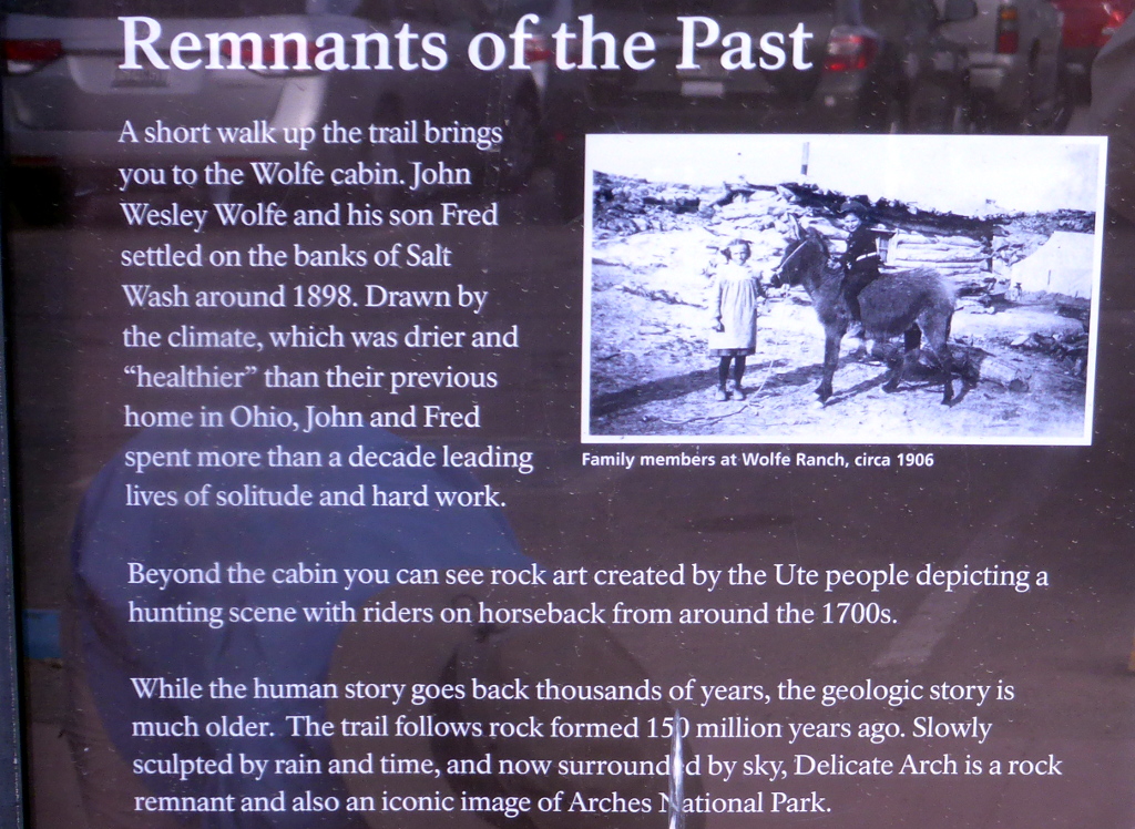
Almost immediately the trail passed by the John Wolfe cabin. John moved to this spot from Etna, Ohio -- just east of where Joan and I live -- at age 69 seeking relief from a Civil war wound by moving to a drier climate, accompanied by his eldest son. They built a one-room, dirt-floor cabin, and there was enough grass to raise a few cattle at his "Bar DX" ranch.
After a decade John's daughter, her husband and two small children also moved here, and she persuaded/forced him to improve the cabin, which gained a wood floor and a 100-piece china set. The structure is still here today, a hundred years later.
The trail began to switchback and passed by petroglyphs left by the Ute peoples.
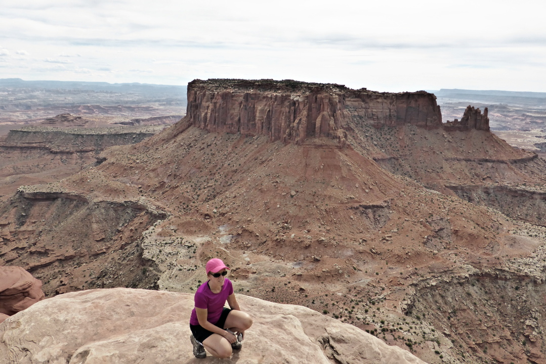
As we gained altitude we could look back to the parking area. The occasional layers of pale green in the hills are volcanic ash (click on the image to enlarge).
We hiked on, gradually climbing and approaching an outcropping of slickrock.
Even early in the morning there was a steady succession of pilgrims crossing the reflective slickrock.
Some of our fellow hikers' clothes seemed out of place, such as a long, flowing red dress and two-piece running togs that demanded lots of sunscreen.

The trail became more gradual and swung to the right. After treading carefully on the now-elevated path, Joan and I drew close to the Delicate Arch. There's a knot of people in the upper right of this photo.
A backup forms because a three or four foot lip separates the trail from the bowl, slowing the hikers, who ponder the best way to  approach the arch.
Once inside the bowl we crossed a canted surface to draw closer.
Everybody wanted a photo of themselves or their friends standing underneath the arch, of course, whether taken by helpful fellow hikers or by means of a selfie stick. Eventually it was our turn and I took a picture of Joan holding our two piggies, Zorba and Paco.
Photo opportunities abounded here, but my narrative needs to keep moving.

Our group grabbed the last shaded spot in a picnic area for lunch. We were thankful for the shade, as the heat had built up considerably. Tim and Clint, our guides, then drove us to our next destination, Devil's Garden and Landscape Arch. As always, there was a sign at the parking area.
The path is wide at first, but it soon reaches a narrow passage.
Consider the curved strata in the column on the left.
Two bands diverge in this formation; the lower one dips down.
Hey -- is that Landscape Arch ahead?
Getting closer ...
Visitors are no longer allowed under this arch; pieces have been falling off!
A section on the right separated in 1991 after several days of rain. As Tim commented, "Perhaps this arch should be 'Delicate Arch'!"
 If any more breaks off, the whole structure may come tumbling down.
I was dressed with sunhat, long-sleeved shirt, and long pants, but there were sun-worshippers here perched on the boulders. Not for us!

Our day in Arches National Park continues in the next post.

Wednesday, May 4, 2016

CW: Fisher Towers and Canyonlands

September 30th started with this wonderful view from our patio at the Red Cliffs Lodge.
Joan and I breakfasted in cool morning air on the deck of the restaurant, during which I kept going back for more of the Best Date Cake Squares Ever.

While most of the Country Walkers group elected to go rafting with Tim on the Colorado (class I and some class II water), Michelle, Joan, and I went with Clint to hike on the Fisher Towers trail.
The trail is notoriously hot in the afternoons, but this morning we were still in the shade.
The route does dip through a few gullies.
Wouldn't want to be down here in a thunderstorm.
The towers are a magnet for rock climbers. Can you spot two near the top of this photo? (Click on the image to enlarge).
From the top of a ridge we could look back at the parking area. The green strip at the base of the far mesa demarcates the Colorado River.
The climbers took turns scaling the final pinnacle.
I don't intend to ever take a route that requires being roped! (Note how slender the pinnacle appears from a different angle, below.)
We started our return journey as the climbers began to descend. Having been to the top did not guarantee them an easy trip back down.
On the way we came across this colorful critter, probably a beetle, but even with an extensive online search I couldn't identify it. It somewhat resembles the reticulated netwing beetle, but the colors and patterning aren't quite right.
Our two groups met back at the lodge for a picnic lunch at the shelter house.
Our afternoon adventure is a trip to the Island in the Sky section of the Canyonlands National Park.
We disembarked from our vans at the Grand View Point Overlook.
And it's a spectacular sight, a product of hundreds of millions of years of deposition, uplift, and then erosion.
Here's a closer look at a portion of these canyons.
Some folks hang out here, drinking it all in, and don't need to hike any further.
But it's an easy walk out to the furthest point of this mesa, and that's what we did. This shot is an example of the trail.
To the west the Green River, the major tributary of the Colorado River, approaches us.
The trail ends at a climbable promontory.  The river courses are 2,000 feet below us.
The landscape is vast from this perch.
It makes a good backdrop, too.

Both headed out and on our return, we drove past the Moab Tailings Pile. In 1952 Charlie Steen discovered the largest uranium deposit in the United States near Moab, and now the Department of Energy is overseeing the removal of 16,000,000 tons of uranium mine tailings, covering 130 acres, to a safe disposal 30 miles away. The Pile is a restricted site, of course, but from the highway we could see dump trucks being sprayed down, then carrying their loads to containers which are then sealed and loaded on a train.

For dinner this evening a few of our group journeyed into Moab, but most of us took it easy by eating at the Red Cliffs Lodge, and all had a jolly time.

Tuesday, May 3, 2016

Dead Ash Trees and a Big Crane

Today two green trucks roared into our neighborhood, one towing a huge crane and one towing a beefy chipper. Our neighbor two doors to the north had harbored dead ash trees behind his house for a few years, victims of the emerald ash borer, and a month or two ago his luck ran out. An ash around which his deck had been built toppled and dented his roof; fortunately, it didn't have enough momentum to crash into the attic. Major parts from other ashes were either on his roof or suspended above it by means of branches entangled with other dead ashes.

A basic cleanup of the damage had been done, but the skeletons of several ashes still loomed, menacing, over the house. Today was tree removal day, big time.

The crane fit between the afflicted home and the one north.
Tree trunks began to come down in segments.
Here, the top of the second tree to be removed has been hoisted over the house, and is swinging towards the chipper.
Feeding into the chipper, with the cooperation of the crane. Partway through the branches will be cut off with a chainsaw.
Here is a video clip of some of the proceedings; there are two parts separated by a brief fade-out.


Wow! I'm glad I wasn't in the house next door.

Friday, April 29, 2016

CW: Morning Glory Bridge

After breakfast the next day (Sept. 29th) our Country Walkers group piled into the two vans and descended from Mesa Verde, bound for Moab, Utah. The drive consumed the morning, with a gas/rest stop in Monticello and a brief photo op at Church Rock, so named through its association with a religious group led by Marie Ogden.
The drive was about 143 miles, and took us down to 4,000' in altitude. We had a great lunch at the Moab Diner.
Afterwards we drove on through Moab, turned right at the Colorado River, and stopped to hike Negro Bill Canyon,
all the way to Morning Glory Bridge.
At this lower altitude it was hot; the temperature in Moab was 90º. Initially we were in direct sun,
but as the canyon narrowed there was more shade. The trail crossed and recrossed a creek at the bottom of the canyon.
Although the trail doesn't gain much altitude, there were short bursts of ridge scaling.
Outside the creek it's an austere, xeric landscape.
Eventually the "bridge" came into sight at the end of a side canyon.
Some consider Morning Glory Bridge an alcove arch, others consider it a natural land bridge due to the trickle of water that dribbles down the side of the canyon and passes below the formation. This photo captures only a section of it.
Its size can't be comprehended without human figures for scale. Here some of us stand underneath; the base of the arch is on the far right.
Tim Smith, our chief guide, gave us an overview of the geological forces that created the arch.

When we started back, these eroded forms captured my eye. Giant beehives, anyone?
This picture captures the most difficult creek crossing. A tilted rock has formed a pool, and the level of the creek on the other side, still deep, is several feet lower. Negotiating the transition from bankside to the rock's edge is made trickier by an ill-placed boulder. Tim and Clint assisted everyone across, one at a time. Only one of us (besides the guides) got wet feet here.
By the time we passed over this ledge, the shadows had become much longer.
Our group then drove several miles further upstream along the Colorado, to the Red Cliffs Lodge. This extensive resort even has a small museum dedicated to the movies that have been filmed in or otherwise connected with Moab.

We unpacked in our spacious rooms, relaxed over dinner,
and made our choices for tomorrow, either rafting on the Colorado or a hike at Fisher Towers.