Showing posts with label zion canyon. Show all posts

Wednesday, July 6, 2016

CW: Up the Narrows at Zion National Park

Yesterday (Oct. 7th) we gawked at Zion Canyon from above as we climbed to Observation Point. Today our Country Walkers group would walk and wade up The Narrows, where the North Fork of the Virgin River descends from the mesa tops and cuts through the canyon.

The first step was to visit an outfitter, where we chose river-walking shoes, neoprene socks (a wet suit for the feet), and poles. We also watched an introductory video. Fortunately, today the water volume was at a level safe for newbies. The river is closed to walkers during the spring snow melt, and when the flow rate (published by the USGS) exceeds 150 CFS (cubic feet per second).

The second step was to drive to the Zion Visitors Center and walk over to the shuttle stop.
We rode to the end of the line, the turnaround point,
at the Temple of Sinawava.
From this point there is a one-mile paved trail,
after which adventurers must wade up the river. There are no restrooms beyond the shuttle drop-off.

Eric and Heather, our guides, paused opposite a popular rock-climbing face,
and gave us a demonstration of climbing techniques, rotated 90ยบ so that they were moving along a fence -- a horizontal "climb."
Then we had a geology, hydrology, and zoology stop.
Rainwater percolates slowly through the upper sandstone layers, and then drips out when it encounters a less permeable layer.
These drips are a small but reliable source of water, because it takes up to 1,000 years for the water to migrate through the porous sandstones after it hits the mesa tops. This apparent invulnerability to periodic droughts led the original inhabitants of the region to call such a formation a "House of Rain," also the title of a famous book about that era.

A tiny fresh-water snail, wet-rock physa, makes a living on these rock walls. This species is endemic (limited to) Zion Canyon and the connected Orderville Canyon, a stretch of about 3 miles. My photo is somewhat blurry!
At the end of the paved trail the wet walk begins with a warning sign. No guides or permits are required for river walking in this direction, so visitors could and do arrive with any degree of preparation, including none. (There is a strict reservation/permit system for hiking from the top down.)
The group took its first get-acquainted steps into the river.
The stream is still wide at this point.
I didn't trust myself to successfully hold camera and pole simultaneously, so many times I would stop, retrieve the camera, take the picture, and re-stow the camera.

Mom and daughter, barefoot, pondered whether to continue. Mom's holding a pair of hiking boots.
The river winds back and forth, and with this water level we were constantly crossing and recrossing the stream. Once the water was more than a few inches deep, the rocks on the bottom were invisible, making the poles handy not only as a brace, but as a depth finder.
Water is so much denser than air that we took even easy steps slowly.


The canyon grew narrower as we ascended, and often there was wall-to-wall water, even at that day's modest flow.
On our way up we stopped for lunch and to make any needed adjustments to our footgear. We arrived at our turnaround point, a huge, distinctive boulder. Heather took a photo of Joan and me in front of the rock, and also of other hikers.
While standing at the boulder she took this picture of several of us against the canyon wall.
We began our trip back downstream, and saw the canyon walls in a changed afternoon light.
This photographer had great trust in his tripod.
Weary but satisfied, we retraced our steps, shuttle ride, and van ride. The deer at the Desert Pearl was waiting for us.
That evening we enjoyed a grand dinner to say farewell to Zion National Park, which we would leave in the morning.

Monday, July 4, 2016

CW: Zion Canyon and Observation Point

October 7th was a hiking day on this Country Walkers visit to Zion Canyon National Park. Because Angel's Landing, the most famous hiking destination in the park, was temporarily closed for trail repair, we headed for Observation Point.

Reaching the trailhead was a two-step process. During the tourist season, private vehicles are not allowed into the canyon -- there is almost no place for parking in the canyon, which begins narrow and grows narrower. After parking in the extensive lots at the Zion Visitor Center, visitors must board one of the circulating shuttle buses. Only those overnighting at the mid-canyon Zion Lodge are exempt. 

In this map, the visitor center is highlighted in red (ellipse), and the point beyond which private vehicles are not permitted is marked with a red square. The background of the park is "satellite view," while the town of Springdale is in "map view."
Did I say extensive parking areas?
Heather and Eric, our guides, parked the vans and then made sure we had full water bottles; the center has outside taps. We boarded the shuttle and disembarked at the Weeping Rock stop.

This sign explained how wood from the mesa tops was lowered into the canyon for construction, starting in 1900, by a system of cables from the cliff edges. Before this, lumber had to travel for two weeks from Arizona to reach Zion.
Some of the cable works still cling to the rim, but they were too far away for a decent photo.

The Observation Point trail started with moderate, paved, gently sweeping switchbacks. Nonetheless, there were warnings about what might lie ahead.

One group, including Joan and me, set off with Heather directly for Observation Point. The rest went with Eric to explore other spots in this location.

In this image (an afternoon shot) you can see a trail switchback lower down, in the lower left, through brush. The mid-canyon formation deflecting the river into a big bend is called The Organ, and above and to the left looms Angel's Landing.
After gaining altitude the trail dove into a gorge cut between heights.
 The bottom wasn't visible when we looked straight down.
In a few minutes the gorge bottom began to peek out at us.
In spots the trail and the floor of the gorge were one and the same. (Not a good spot to be in during thunderstorms.)
Here it was a bit wider.
A generous path and a deep cut.
As we walked higher the feeling of being trapped between two walls fell away.
The trail broke out onto the mountainside.
This trail was blasted and hacked and irregularities paved over by the CCC (Civilian Conservation Corps) in the 1930s.
It is still a good idea to watch your step, because the intervening years have broken up the paving in places. (There's never been any need for paving the section atop the mesa.)

Then we were above the level of Angel's Landing, and getting closer to the top of the canyon.
Hoodoos on the mesa opposite Angel's Landing.

The final stretch of the Observation Point trail made a broad arc along the top to reach the viewpoint. This picture looks back to the trail climbing the last, steep switchbacks to the rim.
With Angel's Landing closed, we weren't the only hikers at Observation Point, and the best sitting spots were already taken. Standing at the point, however, we had a great view down the canyon.
There was much else to see here, including red-tailed hawks chivying and pursuing a swiftly cruising peregrine falcon. Joan and I were glad to have carried the weight of our binoculars.

Our chosen lunch spot was off the side of the trail, a few dozen yards back from the crowded viewpoint. We could look down into the main canyon, but took care not to let our meals or poles slide down into it.
There were people down there, and so we would be, tomorrow (click on the image to enlarge it). The canyon becomes narrower and narrower the further upstream one goes.
The trip back down was pleasant but uneventful. We hopped onto a shuttle, transferred to our Country Walkers vans at the visitors center, and returned to Springdale, tired but happy.

Arriving back at the Desert Pearl, we discovered a deer browsing the parking lot grass. He wasn't concerned about us.

Tomorrow would be the opposite of climbing the heights; our group would plunge up Zion Canyon through the waters of the Zion Narrows (the North Fork of the Virgin River). On foot.

Sunday, June 19, 2016

CW: From Bryce to Zion

The next day (Oct. 6th) took our Country Walkers group from Bryce Canyon to Zion Canyon with multiple stops in-between. First, Joan and I grabbed a quick look at the sunrise palette reinforcing the colors of this spectacular canyon.
 Here's a more panoramic view.
After breakfast our group took a walk along the canyon rim, starting with a visit to Bryce Point.
There's a fenced observation point here,
with a history of the eponymous Bryce family. (Click on the image to enlarge.)
The view from Bryce Point.
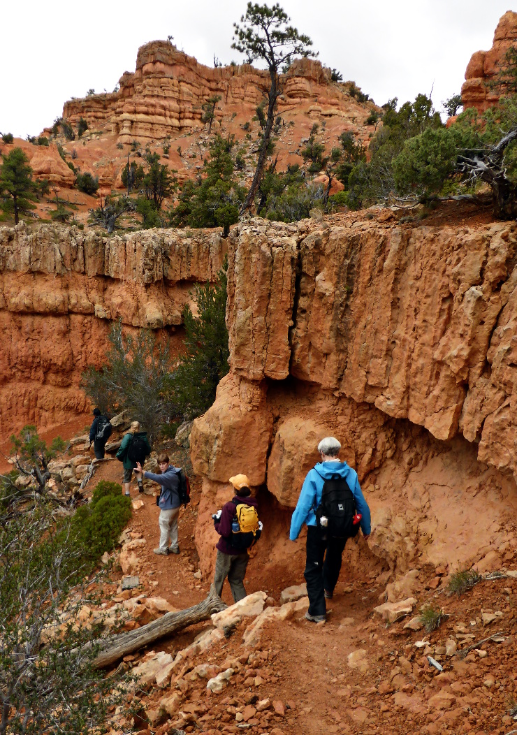
Then we hiked along the rim. This overturned stump graciously agreed to pose for me.
Much of the time we could look down to paths we were hiking yesterday.

When the formations aligned, the lines of towers appeared deliberately constructed. In reviewing this photo, I was struck by the resemblance to a forest of pleated carbon nanotubes.
At the far end of the walk we piled into our vans, and the first stop was at Losee Canyon, in the Dixie National Forest.
We were there for a brief visit to the arches.
The trail switchbacked up a short ridge.
The top of the ridge had some great viewpoints.

A short walk along the ridgeline,
and we were at the windows/arches.
What's the difference between a window and an arch? Technically, when the opening extends all the way to the ground, it's an arch. This formation has both.
We headed back by completing the loop, past columns,
and down steps.
We reached our vans just as it started to rain. Driving towards Zion in a steady rain, we stopped for lunch at the bakery Backerei Forscher, in Orderville, Utah. Afterwards the rain tapered off, just in time for our stop at the Maynard Dixon Home and Studio.
First there was an introduction, and artwork to admire.
Maynard Dixon (1875-1946) was a noted illustrator, landscape, and mural painter of the early 20th-century American West.
Here is the main house, built about 1939.
A glimpse of the interior.
Nearby is the bunkhouse.
Here's the "note" on the door.
The addition is well-lit.
A third building is Dixon's studio, not completely finished at the time of his death.
It's spacious inside.

Then it was time to shove off for Zion National Park, not far away. The traffic was heavy at this time of day, and the parking lots near the Zion-Mt. Carmel Tunnel were full. Our Country Walkers group was headed for the Canyon Overlook, and the trail starts near the higher end of the tunnel, which is 1.1 miles long and gains 800 feet.
The first of our two vans couldn't find a place to park and was forced to drive through the tunnel, turn around, and come back up. Joan and I were in the second van, which found a place to park along the side of the road. In this photo we're walking towards the trailhead. The traffic ropes prevent any left turn into or out of a small parking lot across the congested road.
The tunnel was built between 1927 and 1930, before the era of huge cars, trucks, campers, and RVs. Any vehicle over a certain size must purchase a $15 tunnel permit. When such a mobile obstacle is in the tunnel, the tunnel must operate in one direction only. Which means traffic must wait.
This is the sign for the Canyon Overlook.
The trail began with a staircase, and soon we were looking down on the traffic. In this photo there's a car, centered left-to-right and about two-thirds of the way down. (Click on the image to enlarge.)
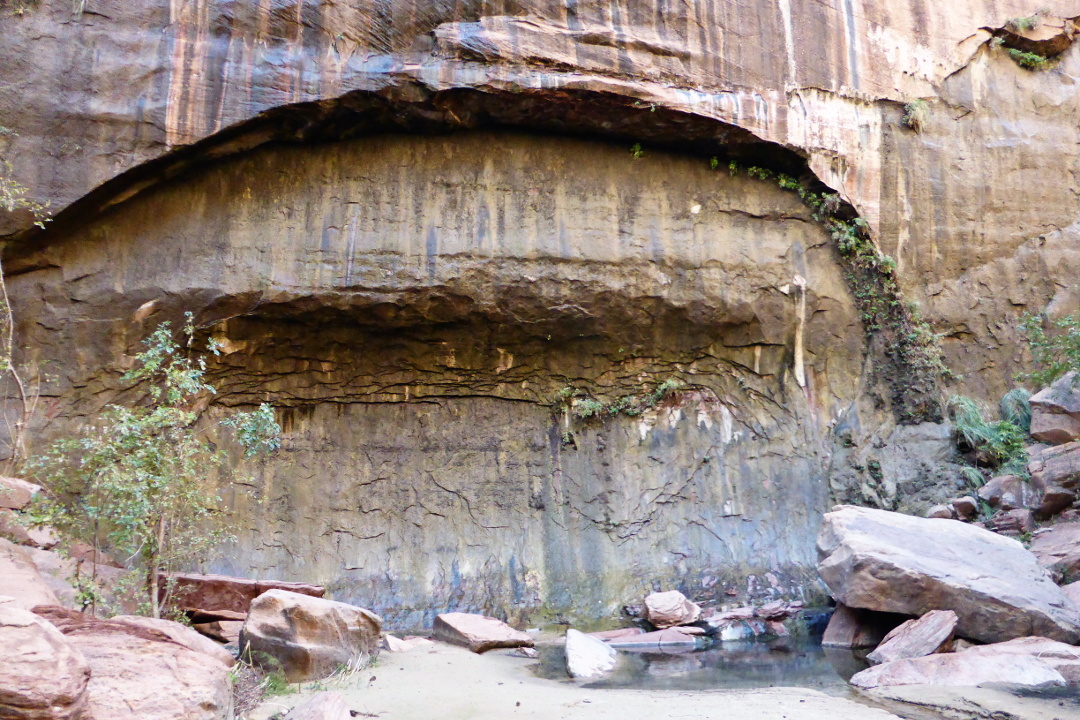
The Canyon Overlook Trail is mostly over slickrock and has exciting portions. This photo looks back to a section where it passes under an overhang. 
The other side of the gorge was impressive too.
Approaching the overlook.
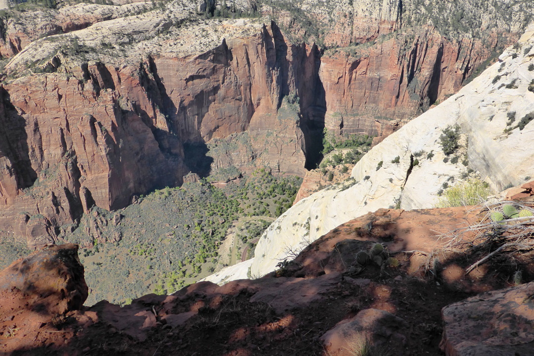
The view was more than worth the walk.
Across the way and lower down, we spotted the windows of the road tunnel. Stopping a vehicle to check out the view is forbidden.
We walked across the slickrock to start our return.
The traffic had become more reasonable by the time we returned to our vans. After diving through the tunnel and looping around the switchbacks, we had a brief pause to take a photo of the overlook from below.
Then we entered the small town of Springdale, which sits just outside the park. We checked into our motel, the Desert Pearl, and had a group dinner in town.

It was a non-stop day!