Joan and I are usually not fans of dining outdoors. Often the sun is in your eyes, or it's too hot, or the wind blows your napkin away, or there's noisy traffic at your elbow. This morning, May 7th, was different. The weather was perfect for breakfast on the terrace, under the shade of a table umbrella. First, a view from our window at the Uma Punakha.
Across the valley the sun's rays were stretching for the Khamsum Yulley Namgyal, a temple built by the Queen Mother, one of the four wives (all sisters) of the fourth King. It's an easy hike from the suspension bridge where our rafts set out yesterday; Joan and I visited the temple in 2005, so not on this trip.
This morning was also a good birding opportunity. We saw a long-tailed shrike and a grey-backed shrike, although they were too distant for a photo. Yes, you must take your binoculars to breakfast. Here is a black bulbul.
Our journey to Trongsa started by driving on the eastern side of the Puna Tsang Chhu, past the New Town of Wangdi Phodrang (alternatively Wangdue Phodrang). A screenshot from Google Maps is in order:
The old town, and the dzong, clung to the top of the bluff on the eastern side of the river, near the confluence with the Dang Chhu, at the bottom of the photo. The main road from Thimphu follows the western bank of the river, and crosses a bridge to climb to the old town. It was perilous living atop the bluff, as this picture from 2009 shows.
Not only was there a long fall, but the buildings were all old wooden structures and highly flammable. Therefore, the government decided to build a new, modern town in a better spot just north. The platting of the new town is easily visible in the Maps screenshot. And then in June 2012 the dzong, built in 1638, burned to the ground. By good luck the relics kept in this third-oldest dzong in Bhutan had been moved elsewhere because of a renovation effort, and hence were safe. Bhutan has pledged to rebuild the dzong by the end of 2018, and the government of India is contributing at least half the funds. The people have moved into New Town. It appears, from the road, to be inhabitable but unimaginative, like most planned communities. Additional colors, architectural styles, and some green space would improve it. We kept going and joined the national highway, leaving the map heading east towards Nobding. There is a huge hydroelectric facility being constructed on the river south of Wangdue Phodrang, and the quarry supplying much of the material is on the national highway partway towards Nobding. The pavement therefore often goes missing,
beaten, fractured, and scattered by all the trucks.
The government has concluded that there's no point in repaving until the hydro project is finished. I grabbed this snapshot of the quarry entrance as we drove by.
In some places mountain streams crossing the roadway had softened the hard-packed earth. We never became mired, but I wonder about the effect of the summer rains.
At Nobding we took a brief rest and snack stop. We had made quick stops in Nobding in 2005 and in 2009, but never at a restaurant.
It wasn't lunchtime yet, but we had tea and "biscuits" -- both salty and sweet crackers -- in what appeared to be a VIP alcove.
Photos of the past and present royalty hung on the walls. Here we see the third king of Bhutan and his wife. He reigned from 1952 - 1972 and began the modernization process of Bhutan, including freeing the serfs and introducing wheeled vehicles. His death at age 43 from lung cancer is the primary reason that tobacco is highly regulated in Bhutan.
This photo shows the young fourth king. He reigned from 1972 (at age 17) until he abdicated in favor of his eldest son in 2006, having accomplished great feats of careful modernization and the conversion, at his own initiative, of Bhutan to a constitutional monarchy.
This is the view from the restaurant towards Nobding.
We left Nobding and crossed Pele La, a pass at 3420 meters or about 11,200 feet, and then began the long descent towards Trongsa. Shortly before our lunch stop we paused while a truck offered assistance to a taxi that had run off the road.
I took this photo looking down the valley in the direction we were headed. We're not far from the village of Rukubji/Rukhubji, but we'll stop for lunch and a walk first.
Tshering sneaks into the photo of some flowers at our lunch stop, the Tushita Café. This restaurant is new to Joan and me.
Joan checks the bird book while the buffet is being set up; she had spotted a himalayan griffon vulture when we first stepped out of the van. It's a huge bird, and reminded us of the Andean condor.
We tucked into a great buffet. The Bhutanese food is tasty, and we discovered that we could eat with abandon and not gain weight. Joan and I decided it was because the food was prepared simply, and not with quantities of commercial fats and oils. Also, the dinner desserts were mostly fruit. When we resumed our drive we passed the restaurant that we'd used in 2009. It was jammed with commercial bus traffic.
Joan, Tshering, and I disembarked from the van for a cross-country walk, and Kaka drove on to Rukhubji. First we worked our way downslope to the valley bottom, walking beside fields and over fences with wooden stepladders. Joan and I wore our rain jackets because the low clouds would occasionally let loose a few drops; Tshering had an umbrella. Walking through Rukhubji was something I might not have had the nerve to do on my own, but with Tshering in the lead and serving as translator, I remained inside my comfort zone.
This building includes among its exterior art a phallus, an invocation of Drukpa Kunley/Kinley, the divine madman of the 15th Century.
There are also vegetable gardens.
At the edge of the village a new building is going up; this illustrates traditional Bhutanese architecture. A master carpenter marks the dimensions and lengths of the timber, and willing hands cut and fit.
As we left Joan and I were being teased by cuckoos that sounded as if they were only at arm's length, but we could never spot them. We broke off the search when a rain shower began to intensify, and in a few minutes were back in the van. The light drizzle continued. We noticed well-dressed villagers waiting by the side of the road, mile after mile, even in the rain. They were waiting for a glimpse of the Je Khenpo, the head abbot and religious authority figure of Bhutan, who was making his way back from eastern Bhutan. If they were fortunate they would be able to give him some offerings. The rain lifted. Later on the road we encountered a troupe of rhesus macaques. (That ID appears to be a better fit than eastern assamese macaques, the other possibility.)
They were unafraid of us, and had obviously encountered people many times before. One had some yellow strings around his neck.
Consider the faces. Someone is in there, watching and waiting to see what will happen.
There was also a youngster.
In Trongsa we stayed at the Yangkhil Resort. Tshering advised us that, although it had been safe to partake of raw foods at the Zhiwa Ling in Paro and the Uma Punakha, now it was time for us chillips (foreign tourists) to eat uncooked food only when we could peel it ourselves. Joan and I also knew that it was time to switch from coffee to tea; this far east, any coffee ordered would be made from instant. This photo, taken the next day, shows the complete grounds of the Yangkhil.
Here was the easternmost extent of our prior travels in Bhutan. Tomorrow we would bash on.
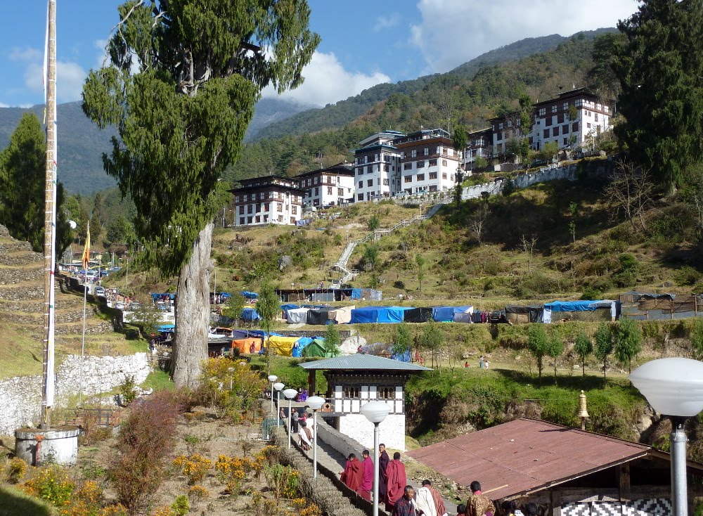
Early the next morning we were off to the second day of the Trongsa tsechu. Advance warning: with the festival being such a feast for the senses, I've got a lot of pictures and videos in this post. Take a deep breath and plunge in. With parking at a premium, the bus let us off a short way from the dzong.
The plastic tarps are temporary shops, bars, and videogame parlors. One of the snack and beverage establishments was run by the wife of Tshering, our driver. For now she lives in Trongsa with the four kids while Tshering, for his job, lives in Thimphu. It's not easy, but they're working hard. Here is Tshering with his two youngest.
People were beginning to gather at the main courtyard, where the performance space was marked off with red carpets. Some of the choice spots were already filling up.
Soon the procession of local notables began.
Here, the Guru Rinpoche figure is seated along the far wall, where he will remain for three or more hours, and an early segment of the dance of the Eight Manifestations of Guru Rinpoche has begun.
Here is a closeup of one of the figures.
Everybody dresses up for the tsechu.
If you're going to keep your spot, you need snacks, especially for the kids. Here is a brief closeup of a dancer and Guru Rinpoche.
A grandmother ponders the passing atsara.
This family group has it all, including pink mittens.
Those horns you've been hearing? Here they are.
The viewers sat or stood in the courtyard and along either side, while some perched on the wall of a higher courtyard. Here's the view down to the show.
As the time grew closer for the offering of blessings, the crowd grew thicker.
Here is a zoom-in of the blessings being offered.
Joan and I decided to take a break from the show, and wandered among the shops. We visited Tshering's place, watched a jeep almost get stuck in the mud near the darts range, and also glanced at some dice games. Here is another perspective on the rows of stalls.
When we returned, the line for offering respect and receiving blessings was as long as before. The dakinis have great stamina; they did their slow steps for hours.
Here is a closeup of a dakini. Although they are female celestial beings, they are played by men.
The apron and cuff ornaments are made from bone. This is a reminder of impermanence. Lo and behold, shortly after we reentered the courtyard, finding the rest of our group, Tsewang came up to us. The man has connections. He had acquired a blessed string (reddish shade of orange, with a knot in the center) for each of us! He gave us basic instructions for wearing it, including that it should be worn for at least three days. I'm a couple of days away from a month, and mine's still in good shape. Here, a policeman tries to squeeze past Guru Rinpoche as the saint takes his last circumambulation of the courtyard, and the attending atsara is not amused.
After the blessings, the Guru Rinpoche figure is escorted out of the courtyard.
After a morning full of sight and sound, it's time for us to leave and get lunch. The view leaving the dzong ...
After lunch, Tsewang and Jen pass through the gate at Yangkhil Resort.
Our bus awaits, clean and shining.
Our long afternoon drive was back up to Pele La, and then taking the side road into the Phobjikha valley, a winter home of the black-necked cranes. Along the way was one of the locations used in the filming of the movie Travelers and Magicians.
We arrived at Dewachen Hotel in Phobjikha after a very full day. And you're probably glad to finally reach the end of this post! Congratulations.
First, a confession. I may have sounded knowledgeable in the previous post, rattling off place names such as Rukubji, but I'm not really that organized. I took a notebook along and wrote nothing in it! However, if I can remember the salient characteristic of a spot (snake head demon, iron bridge monk) I can usually Google a reference to ferret out those nagging specifics. A really good reference might merit a hyperlink. We had time to visit the Trongsa dzong in the late afternoon. Here, Tsewang explains something while we are in one of the many courtyards.
Tsewang is wearing a white kabney, or knotted scarf, which every male is obliged to wear in official settings (in the dzong, the gallery of parliament, and so forth). Many grades exist: the king wears yellow, members of parliament blue, judges green, and so forth. The women wear a sash called a rachu, which also has color significations. Here Tsewang is describing a Wheel of Life painting within the dzong.
And here a cosmological painting, with Mount Meru in the center, and the four directions.
In another courtyard, some laymen (with monks watching) are practicing for the upcoming festival.
A closeup ...
I couldn't imagine jumping up and down on those cold stones barefoot. They have tough feet in Bhutan, as befits such a mountainous landscape. We were told that one traditional standard of attractiveness in men was the size of their calves.
Google Maps/Earth has a good bird's eye view of the sprawling dzong. In the next courtyard, we came across monks rehearsing. The time came to return to our hotel, have dinner, and repack. The trek would begin tomorrow, and we needed to reorganize so that the things needed for the trek would be together, and things not needed for the trek would be in a bag that could be left behind. At dinner, Namgay showed us how to put on a gho.
Note that the gho starts at floor-length. Eventually it gets pulled up to knee length, and the extra material forms a huge pocket that hangs over the belt. Good for cell phones, documents, puppies ... whatever. It's also necessary to align the back.
The next morning, repacked, I got some good pictures of Yangkhil Resort. Here's the main office and dining room.
Here is one of the residential buildings; each has four rooms.
Off the patio next to the dining room is a water-powered prayer wheel, generating merit 24/7. The early morning light was also flattering to the dzong as we left town.
We left Trongsa headed south, paralleling the Mangde Chu. We paid a brief visit to Kuenga Rabten, where the winter palace of the second King of Bhutan was built. It now has a caretaker and some young monks. Here is part of the contents of the library.
Because it was winter break, most of the monks had dispersed to their homes. A few young ones were playing darts (khuru) in the lawn.
We drove on, and serendipity struck, as it seems to often do in Bhutan. A village was having its local festival, a smaller version of the great tsechu that would start in Trongsa in a week. Here is a short clip of the dancers. Note the masked figure on the far left in the first few seconds; it's an atsara. This term is usually translated as 'clown', but they do a lot more. For instance, if a dancer has a piece of costume come loose, the atsara comes over to fix it while the dancer keeps going. The atsara will also harangue audience members, especially chilip (which means foreigner, in a matter-of-fact, non-pejorative way). He's looking for donations to the fund for the festival and festival refreshments. A closer look at the dancers.
The back of the atsara's costume.
Another view of the proceedings.
Everybody dresses in their best for the festival (except the chilip). Not only to impress the neighbors; for the young singles, it's a chance to meet and mingle.
We had six or seven miles to hike that afternoon, so after 20 minutes at the festival Tshering drove us on to the trailhead, where we had lunch and identified our trekking duffels to the porters. Our first trail lunch was hot and yummy, a good omen of things to come. Here's a photo of the trailhead.
This trail, known as the Nabji-Korphu trail, is Bhutan's first experiment in community-based ecotourism. Each village along the route was empowered to choose where the campsite was to be built, and each village supplies a guide, porters, and a campsite caretaker. Income from the trekking may go into a community fund, for schools or other improvements, or the jobs may be rotated among the households of the village. The government of Bhutan intends for the program to boost the economy of out-of-the-way places, and not to benefit a few lucky or influential individuals. On this trail, each trekking group is limited to no more than 11 participants, and no more than one group may be on the trail at a time. In the next post, we set off.