On July 25th, 2023, Joan and I aimed for a hike to the Inkpots and beyond. We drove back down to Highway 1A from the Storm Mountain Lodge and pulled into a parking area just east of the Moose Meadows. This was a strategic choice; although it would add some distance to the hike, it avoided the hordes and impossible parking at the Johnston Canyon trailhead. (Click on any image to enlarge.)
The first stretch of trail was wooded, wide, and climbed gradually.
Our "secret" trail began climbing in earnest, joining the Inkpots trail after 3.2 km, or 2 miles. By avoiding the Johnston Canyon section we had yet to see another soul.
The next stretch of trail was wider, and rolled up and down with a final descent into the valley holding the Inkpots. This sign greeted us on arrival.Looking down as we approached the valley floor.Here's one of the larger ponds.At the bottom, I took this video of the huffing and puffing at a pond's bottom. The upwelling keeps the ponds at a constant 4° C (39° F).
Good viewpoints are spread around the lower reaches of the valley.

The route was rocky but plain to see.This white admiral needs to be better camouflaged!
A few people had congregated at the bridge over the river but were reluctant to attempt it. The wooden structure consisted of two boards on edge, not flat, with only one handrail, and steps up and down at each end. |
The bridge is circled in yellow.
|
We crossed without mishap, but nobody followed. On the other side we met this battered sign.At first, we wandered through willows and other brush as the gap between us and the river on our left widened. Then we climbed to a higher level and finally encountered another hiker. Shortly after that, we arrived at campground Jo 9, also known as Larry's Camp Campground. It consisted of ten campsites and an outhouse. A hop and skip later, we crossed a bridge.We were sitting at a major intersection for back-country exploration.We found a congenial spot under a tree and had our major lunch. While here, Joan and I saw plenty of overnight back-country campers pass by: an enthusiastic solo woman, a youth group, a solo guy, and yet another group.
Retracing our steps to the Inkpots seemed to take half the time it did walking out -- a familiar experience when traversing an area for the first time. However, climbing back out of the Inkpot valley was a heavy-breathing ascent. Then the spur trail to Moose Meadows seemed to go on and on. Eight km or five miles out, same way back. A 10-mile hike ... not bad!
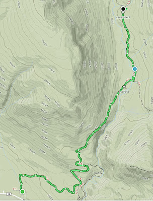
This map contains, in condensed form, our entire route. (Click on any image to enlarge.)


 We found a congenial spot under a tree and had our major lunch. While here, Joan and I saw plenty of overnight back-country campers pass by: an enthusiastic solo woman, a youth group, a solo guy, and yet another group.

No comments:
Post a Comment
Comments may not appear immediately as they are moderated by the author to eliminate spam. Please, no commercial links!