
On July 22nd, Joan and I drove across the continental divide (just a few miles away!) to join the guided Stanley Glacier Hike. The trail is open to the public, but by joining this hike we benefited from commentary and interpretation. The Parks Canada website warns,
From the Stanley Glacier parking, the first 4 km of the trail are gently
graded on well maintained, packed dirt trails. The final section of the
trail includes 800 m of rough trail and 200 m of walking on rough and
loose rocks. This hike is not advised for people with recurring knee,
back, or ankle injuries.
As you can see from this image, the hike starts with switchbacks. Your definition of "gently graded" may vary from that of Parks Canada, but it's not extreme.
 Some early sections were consumed by forest fires in 1968 and 2003, and the lodgepole pines, willows, and other trees are slowly growing back. In this photo, the brownish band halfway up the prominence (click on the image to enlarge) hosts some of the fossils for which the area is famous, along with the Burgess Shale and Mt. Stephen.
 On the way up, our guide called a couple of stops, for a breather and some information about the critters of the Cambrian Period.
 After we climbed up to the lip of the hanging valley, the trees were taller and the brown band more prominent.
 Our group paused for another break before crossing the exit stream. One of our band of hikers ... not Joan! The photos of us didn't turn out well.
 The route began to rise on one side of the valley. Here's a peek looking back. The footing was getting rocky.
 Across the way, the summer melt running off the glacier formed a waterfall.
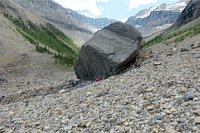
 At lunchtime, we left the path and settled down next to a large boulder. We had time to spread out and look for fossils, primarily trilobites.
 The sky began to cloud over. Our guide decided it was time to start our return, and we kept our rain gear handy. A few moderate showers passed through as we walked down the valley, but thankfully, no thunderstorms erupted.
 Joan and I arrived at the parking area worn out but happy.


