Showing posts with label mesa verde. Show all posts

Thursday, January 2, 2025

Puebloan Mysteries: Mesa Verde

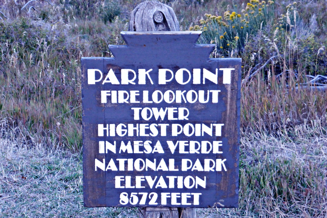
On May 5th, 2024, our Off the Beaten Path small group tour left Durango and spent most of the day exploring Mesa Verde National Park. Our van first stopped at the visitor's center, followed by a winding climb to Park Point, the highest elevation in Mesa Verde at 8,572 feet (2,612 m). Even though the sky was gray, the view was spectacular, including the Sleeping Ute mountains and Shiprock. (Click on any image to enlarge.)
A plaque and our knowledgeable guide, 
John Ninneman, a veteran of many trips, pointed out the features of the landscape.
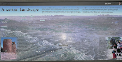
Our road wound southwest towards the Far View Lodge and beyond.
Today would feature a variety of archaeological sites and eras.
When most people hear "Mesa Verde," they are aware only of the Cliff House. We saw much more!
 
The average annual precipitation in this region is estimated to have been about 15-18 inches during its occupation, enough to allow the Ancestral Puebloans to raise corn, beans, and squash. There were drier intervals, including the mid 1100s, but it was the great drought of 1279-1299 that led to the abandonment of Mesa Verde for areas with more reliable water.
 
First,  we stopped at the Far View farming community.
Here are the external kivas.
Another Far View structure ...
Then, a plaque about the Far View House.
The right side of the above plaque includes an image of the remaining multi-room dwelling. I took this ground-level photo.
This excavation is well protected, a testament to the care and respect for history.
A fascinating, detailed kiva design!
Then we piled back into the van and drove to the famous Mesa Verde Cliff Palace.
We were one week too early for the full tour season (in 2024, it began May 12th), so many of the hiking options, including the Cliff Palace
and Balcony House, were closed. I could zoom in with my camera, however,
and use my binoculars.
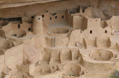
Here, you see a closed stairway.
The restaurant was open, thank goodness, and became our lunch stop. Our next stop was a well-preserved pithouse, one of the earliest permanent dwellings at Mesa Verde.
A plaque explained how the structure could be dated.
And here we have it.
Next, we visited the view of the Square Tower House.
This plaque explained the painstaking work to preserve the threatened structure.
Here's our view of it.
From there, it was on to the Sun Temple.
A short walk took us to the obligatory plaque,
and the broad structure.
We were forbidden to enter, but could peer within all we wanted.
There is debate about whether the symmetrically planned "D" shape building was ever completed, but a huge amount of labor was put into it in any case:
the stone masonry walls were shaped and given a "dimpled" flat surface by the builders. Excavation of debris revealed that the walls were probably between 11 and 14 feet high -- great for secrecy. On tip-toes, I managed to get this view, which shows the concrete that prevents rain from dribbling into the rubble between the walls.
By now, it was mid-afternoon, and our overnight was at least an hour and a half away in Farmington, New Mexico, where we would spend the next two nights. Tomorrow, we will have a full day to explore Chaco Canyon, one of the big draws of this itinerary for Joan and me.

Monday, April 25, 2016

CW: Canyon of the Ancients

Our group started September 28th with a pre-breakfast jaunt to Park Point, the highest elevation in Mesa Verde.
The guides parked our vans at the bottom of a driveway to the fire lookout. Technically you aren't supposed to go further than the closed gate until a ranger arrives, but our Country Walkers guide Tim had cleared this visit ahead of time. The sunrise colors were spectacular.
After walking around the gate and up the driveway, I took panoramic shots in three directions, and still didn't cover the entire 360ยบ of the view. One,
 two,
 and three.
At full zoom, my camera captured the Far View Lodge and associated complex, where we had spent the night.
In the other direction lay the town of Cortez, which we would drive through after breakfast.
And away in Arizona, Shiprock poked up out of the desert. This name resonated with Joan and me because we'd listened to or read many of Tony Hillerman's Navajo Tribal Police mystery novels.
Returning, we reached the closed gate as the ranger drove up. He hadn't gotten the word that our Country Walkers group had been cleared to visit the lookout prior to his arrival. Tim was able to smooth the ruffled feathers quickly; as the ranger departed for the tower, his final words were, "all goodness."

After coffee and breakfast at the lodge, we piled into the two vans and descended about 2,000' from the mesa to the valley floor. Beyond Cortez we found the Canyons of the Ancients National Monument. It was already warm and sunny, and at this lower altitude it was certain to be a hot day. Fortunately we'd been advised to bring plenty of water.
We would be accompanied today by Shawn and Sarah from the Crow Canyon Archaeological Center. Sarah was accompanied by her pack-rat, Peetie.
After an orientation near the entrance, our group launched into the Sand Canyon trail. From this southern trail-head it would be a 13-mile round trip to Sand Canyon Pueblo, so that's not within reach today.
Here we're listening to Shaun.
Not all of the desiccated relics in the monument date from the time of the ancient Puebloans. (Linguistic note: you may be familiar with the term Anasazi. This is a Navajo word for "ancient enemies," and contemporary Pueblo cultures prefer that you use a different tag.)
Early on we encountered this multi-layered hoodoo; hard capstones on top, softer rock in the middle, and chunky stuff on the bottom!
Much of the trail was out in the sun.
A small alcove was next.
Several structures follow this bluff.
This is a closer look at the left-hand side,
and then the right.
Our lunch stop was at the foot of the left-hand side.
After lunch there was a choice. We could return to the start with the two Crow Canyon guides for an atlatl demonstration, or continue with Tim, heading for a "surprise" about half a mile away that he and a friend had discovered several years before. Tim needed three or so tries to find it again, but now clearly knew the way. Joan and I decided to go with the surprise.

Over the past two days we'd learned about the various theories and discussions regarding the arc of the ancient Puebloan culture: how it started as hunting and gathering, then cultivating corn was introduced/adopted, then cliff dwellings became common, and finally this area was abandoned for points further south. Climate change (drought) and warfare have been the most prominent proposals for the exodus. IMHO the answer is probably "all of the above, and they're interrelated."

Here Tim shows us his surprise, what appears to be a watcher's post.
A view from the inside.
The walls had been built with a double course of stone, and at least one peephole or arrow port still exists.
This structure provides a good view of several approaches to the upper canyon.
In conjunction with other "watchtowers," this station could have been a link in a wall of vigilance.

Then we returned to the parking area and discovered that the atlatl demo was over, and the Crow Canyon guides and our other half had already departed. We piled into the remaining van and returned for the Far View Lodge for our second and final night atop Mesa Verde.

Tomorrow we would drive to Moab.