
On September 19th, 2022, the Endurance visited Flatey, an island set in the Breiðafjöður, a name literally meaning "wide fjord." Flatey is just two kilometers long and 1 km wide, and most houses here are occupied only in the summer. (Click on any image to enlarge.) It's primarily known for its deep history.
 We came ashore in zodiacs, of course.
 A closer map:
 Joan and I first headed for the church, famous for its interior.
 As we stepped inside, we gawked at the artwork.
 It's impossible to take in the ceiling all at once.
 The small building behind the church is the community library. It's the smallest and oldest (1864) library in Iceland.
 Joan and I decided to walk through the village and follow paths around the nature sanctuary.
 In late September, near the Arctic Circle, many birds had already departed from this productive tidal zone. A few ducks lingered. Joan and I found ourselves on the wrong side of the fencing after reading a plaque, and after a long walk looking for a gate, we were forced to maneuver over a couple of fences to make our way back to the townsite. Nonetheless, we returned to the zodiac landing in good time.
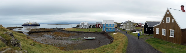 This photo is from the ship as Joan and I watched the last zodiacs embark.
 We spotted a snorkeler in the water and wondered if she was looking at the wreck of the Melckmeyt, or "Milkmaid," which sank during a storm in 1659. (The Endurance scuba team was down to one due to Covid, and scuba diving without a buddy IS NOT DONE.) For some reason, the Lindblad information about today's visit did not mention the Melckmeyt.
 A glimpse of the kayak and zodiac "garage."
 As the ship repositioned, Joan and I took advantage of an offered tour of the engine complex. Here is the control room.
 I noticed that the bubble levels here had three orientations. Ships do rock and roll.
 Much of the energy is transferred by heavy voltages managed by immense cabinets. It's noisy down there.
 South of Flatey, the Snæfellsnes peninsula sticks out, and the Endurance headed there, towards the village of Grundarfjörður. There we had to choose among three excursion options, and Joan and I picked the black sand beach plus volcano museum trip.


There was a howling wind driving bullets of light rain this afternoon. The flag-stoned way to the black sand beach wove through rocky pillars. The beach.
 There were bits of rusted iron scattered about.
 Of course, it was from a shipwreck. This is a protected site.
 After a spin through a volcano museum, most of our group tackled the Saxhóll crater. The route up was tourist-friendly, with grated metal steps much of the way. The caldera has begun to erode.
 Getting close to the top.
 The view towards the sea (obscured by the misty distance).
 Then, it was time to return to the Endurance, warm up, and have dinner. Our ship sailed overnight around the peninsula, headed south and then east for the Vestmannaejar, or Westman, island archipelago and its main island of Heimaey, famous for fishing, puffins, and an almost catastrophic volcanic eruption in 1973.


