Yesterday's rain bequeathed Sunday with clouds blanketing the valley where Mt. Engadine Lodge nestles; at times the far side of the meadow would disappear. By breakfast the fog had begun to rise a bit, while the forecast was for a 40% chance of 1-2 mm of rain.
Joan and I decided that today we would tackle Windtower, which had thwarted us twice before, in 2014 due to a late start, and in 2015 due to the weather. The elevation of the top is a matter of disagreement between web sources, but let's use 8850 feet. The altitude gain from the parking lot is almost 1,000 meters, or about 3,240 feet. Definitely uphill!
Joan and I lingered at breakfast longer than we intended but, after a 20-minute drive from the lodge, were only the second car at the trailhead. The route starts with a hike to West Wind Pass, gaining the first 381m/1,250 feet of altitude.
The very beginning of the trail is steep and rooty, climbing above the deep cut of Spurling Creek.
Mists still filled the lower elevations.
As Joan and I chugged uphill we emerged out of the fog zone.
The view towards the east from West Wind Pass wasn't much; clouds were piled against the slope.
To the west, the way we had come, the Spray Lakes remained cloud-covered as well.
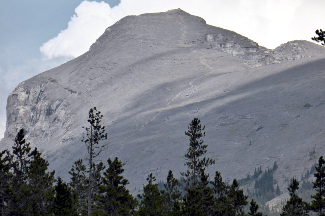
To the south of the pass was our goal, the peak known as Windtower, showing its vertical face.
By hiking along the flank of the mountain we could reach the less intimidating southern slope, as hinted at in this 2015 photo.
Here's an 3-D image of the trek overall.
There is no official route beyond West Wind Pass. Instead, the hiker chooses from a plethora of boot-beaten paths, as shown in another 2015 photo.
The paths weave through trees, open areas, and rock bands that may require use of hands and feet to clamber over. After the first couple of rock bands we spotted an opportunity to hike to a higher route also marked with tape and cairns. Joan and I had read an on-line account that higher was better in this section, so we tried it.
One rock band was uncomfortably tricky to climb; we managed to avoid it on return. This popular hike merits an official trail so that hikers would not need to guess where to cross each rock band.
As we proceeded the mists above the Spray Lakes began to dissolve.
Two women were a short distance behind us, but Joan and I slowly pulled away.
We reached the point where the trail swung to the east and north and more steeply up, as seen in this photo from the lakeside (click on the photo to enlarge). It was a slog the last time and it was a slog this time. It will always be a slog. Many sections demand deliberate placement of the feet, taking into account the scree depth, steepness of the slope, and dampness of the path (one day after the rain). Huffing and puffing, we climbed.
We appreciated our hiking poles and every bit of training acquired on this trip, and even so, we had to pause at times to catch our breath and let the blood flow refresh our legs. So far we had met only one other party, two women on their way back down.
Joan at the top!
The valley carrying the Trans-Canada highway is more than a mile below us.
Another small promontory is a stone's throw away.
 |
| But not easy to reach. |
Rita and Margie took their turn checking out the view from the top seat. We learned later that a registry is buried in that pile.
 |
| They didn't break a sweat. |
A small windbreak was a good spot to have our lunch.
More hikers arrived. We walked over to check out the "nose," a smidge lower than the top.
Behind us, other hikers reached the summit.
Clouds were snagging on Mount Lougheed (about 10,200 feet) as we began our return.
The scree wasn't as bad headed downhill, because sometimes the gravel was thick enough that we could crunch through it like a snowfield. But smaller scree rolled easily and was treacherous.
West Wind pass was spilling over.
 |
| No dark clouds, please. |
Joan and I encountered more hikers headed up. One young woman was dressed in a tank top with a thin, knit, off-the-shoulder sweater and long feathery earrings. This wasn't mountain dress, but she had come this far and clearly intended reach the top alongside her boyfriend.
Then we encountered the mountain biker.
He was pushing his bike up the mountain for the ride down! Joan asked, "Does your mother know what you're doing?" We would see him later.
Sightseeing helicopters of several colors were busy this afternoon, some flying close to the deck through West Wind.
We continued to descend. In this photo clouds are billowing up to the south. The picture also illustrates one of the rock bands.
The hikers that arrived at the top after we did began to shoot by us on the way down. The pass gradually drew closer.
Just as we left West Wind pass the mountain biker whirred by. Given that the trail often clung to the ravine's edge, we hoped he dismounted and walked those sections.
Thunder began to the south, dimly at first, then louder. We kept up the pace as much as the trail allowed and didn't stop. Joan and I reached the car ten minutes before rain showers started; our round-trip time on the hike was 6:10, not bad! Also at the parking area was a woman standing in front of an open car door, shielding her husband, who was changing his clothes.
We drove back to the lodge, where it had obviously rained much harder. We were thankful not to have had rain on the rocky/muddy/rooty West Wind pass trail.
To cap a great day, the moose visited the lodge in the evening -- two males!
 |
| Not feeling territorial. Yet. |


No comments:
Post a Comment
Comments may not appear immediately as they are moderated by the author to eliminate spam. Please, no commercial links!