August 4th dawned with a cloudless sky. The view of Tent Ridge from the deck of Mount Engadine Lodge was promising.
The Alberta FireNet repeater station on top was clearly visible, especially through binoculars.
Joan and I had put Tent Ridge near the top of our list of hikes near Mount Engadine Lodge, but the previous two drizzly days meant that we had time for only our #1 item, Buller Pass, which had undergone a prescribed burn last year. We were intensely curious how the hike looked now, having had an astonishing post-burn surprise in 2009 at Hawk Creek, which is documented briefly here.
We were eager to tackle Buller Pass, even on a transit day, which meant extra driving time. We dashed out of the lodge without saying proper good-byes, and were on the trail early. It starts with a footbridge and several signs.
Of particular interest are the burn notice sign ...
and the distances. Because of all the climbing, 2200 feet of elevation gain, it's more effort than you would think.
The early section of the trail is gentle and unburnt.
Notice the spiderweb in the sun, in the upper right corner? Here is a closeup.
Just before the rebuilt bridge that ends the gentle stretch, there was another novelty, a wildlife observation camera.
Then we crossed the bridge, reconstructed after the burn, and began to climb.
We entered into the burned zones, which were fascinating and raised many questions. The burned areas were hit or miss, interspersed with unaffected woods. How would a prescribed burn differ from an uncontrolled one? We guessed that a prescribed burn would not be as hot, and wouldn't be started on a windy day, so it would be less likely to jump ravines and watercourses. There were at least three kinds of trees: burned trees (charcoal on the outside, foliage all gone), crisped trees (foliage all brown, but little charring), and normal trees.
In this photo there are many 'crisped' trees, but also some untouched low bushes.
Here, there are crisped and charcoaled trees.
The wildflowers love the sunlight, and burst with color against charred logs. Note, too, the unburnt pine needles on the ground.
In places where tree roots had grown into mounds of organic detritus -- moss, needles, bark -- the charred roots were now hanging in the air.
Looking across the valley of Buller Creek, you can see how the prescribed burn formed a variety of shapes. It was not a uniform holocaust.
Lest you form the wrong impression, I'll note that long segments of the trail were still lush:
Then we came to a bridge recrossing Buller Creek. To me, this bridge is an ominous milestone; the switchbacks after this bridge form the second-hardest climb on the trail. The toughest is the slog to the top of the pass itself.
Twenty or so minutes later on there is a well-known waterfall and pool, larger than it looks in this photo.
The trail comes to a meadow, where the valley splits into two arms, north and south. Here we found a tree that was two-faced, part singed and part green.
The north trail, much less used, goes to North Buller Pass, while the southern trail goes to Buller Pass. Joan and I once tried to hike to North Buller Pass, but were defeated by the steep, pathless scree slope at the end. The trail split happens just after this bridge, where Joan points left, towards the otherwise easy to miss north trail.
The next picture is looking back towards the area of the trail junction, just one minute after the above photo.
By the time of the junction the trees have been thinning, and the trend continues as you continue to climb towards the pass.
That doesn't mean that there aren't spectacular patches of wildflowers along the way, such as here, with paintbrush, columbine, and several white species.
The trail leads higher and further into the valley, with the pass almost visible at the end. The trees become more scattered.
Even up here, there are columbine, as shown above, and spectacular alpine forget-me-nots (also the state flower of Alaska).
As the valley rises and narrows the trail gradually steepens; in a couple of spots there were modest patches of snow (August 4th). Joan and I heard some peeping, and after several minutes of scanning with our binoculars, we saw a baby ptarmigan on the other side of the ravine and rivulet that run down the center of the valley. Then the real climbing began.
It was the kind of trail where most of us would walk a short while and then pause to catch our breath, and drink in the view back down the valley whence we had come. Mount Assiniboine slid into view.
Getting closer to the top.
The pass is a funnel for the wind, and no-one stops at the exact top for long. Most move slightly beyond for their lunching, photography, or just resting.
Here is the view down the far side, taken from where Joan and I sat for lunch.
Ribbon Lake is in the center. Ribbon Creek leaves the lake and goes down to Kananaskis Village on Highway 40. At right is Guinn's Pass, which most hikers reach by the Galatea Lakes trail, on the other side of the mountains behind Ribbon Lake. That is a hike Joan and I want to make some day, but it requires being in good shape; it's a long hike, and the last mile of the climb is steeper than Buller Pass.
Some of the other hikers climbed from the pass up the north ridge to a small promontory. Joan and I didn't.
The view from the pass as we began our return journey. The trail seems to plunge off the side of the mountain.
There is something about the return path that emphasizes the ramparts on the south wall of the valley. Even this photo shows only some of them.
My final picture for this hike shows the view a few minutes before we reach the junction of the north and south valleys, on our way back.
After returning to the car, tired but cheered by our success, we drove south along the Smith-Dorrien Spray Trail until we reached Highway 40, and then north again to reach Kananaskis Village, where we would be staying at the Delta Lodge. This would be our base of operations for the remaining hikes of our trip.
The next two days, August 2nd and 3rd, featured morning rains that reduced our hiking. At first, after nine days of hiking, we welcomed the idea of an easier day.
Mr. Moose made a morning visit and departure from the wallow.
The tops of the mountains were in the clouds during breakfast, and showers drifted across the meadow.
After a while the rain retreated, although the sky remained gray. We assembled our gear and took a 2½ hour walk along trails that don't show up on the map:
On the far right is the Smith-Dorrien/Spray Trail, the road from Canmore. A second road roughly parallels the Smith-Dorrien as it goes by the Mount Shark Helipad and on to a parking area. Our mini-hike today was on trails in the green area between the two, starting from Mount Engadine Lodge, and on the Mount Shark road only long enough to cross a bridge.
I neglected to take any pictures of the unofficial trails. We had a fun, exploratory walk, a good lunch, and were rained on for only ten minutes, toward the end. Soon after our return to the lodge a young male deer walked through the parking area and stood, indecisively, atop the road bank. His antlers were still in velvet.
That evening Mr. Moose visited again.
We watched from the deck, which was still wet from the afternoon shower.
The next day we also got off to a late start due to some early showers, but not as late as the day before, and took a much longer leg-stretch. Referring to the map above, we drove to the Mount Shark parking area (not the helipad), and hiked along the main route west, the Watridge Lake trail, which is not easy to see on the map amidst the tangle of cross-country ski routes, although it's obvious on the ground. We hiked past the Karst Spring cutoff, having been there twice before, and reached the left end of the map, lunching at the second creek crossing. We were within spitting distance of the warden's cabin, which we should have investigated but did not.
This sign greets you at the parking area.
It's a warning-in-advance; the Bryant Creek trail is the continuation of our route beyond the warden's cabin, heading up to Mount Assiniboine.
The first part of our walk was on a broad trail, a road really, with the forest on either side. Mountains with interesting strata poked up across the Spray Lakes Reservoir.
The road starts out in the open, with the trees recessed from the trail, but before you reach the Karst Springs trail it narrows somewhat and you're truly in the forest. Beyond the Karst Springs trail, it looks like this:
At the tip of the Spray Lakes Reservoir, things began to happen. First, the Spray River trail came in from the left just after we crossed a bridge. This photo is looking back at that bridge.
Most of the action is along the Bryant Creek trail, at least according to the trail sign.
The Spray River trail is definitely single-file. As the sign above shows, it's a long way to anywhere interesting.
This is the view standing on the bridge and looking down towards the not-quite-visible Spray Lakes.
We continued on the main trail, which briefly paralleled the Spray River. (The hide-and-seek sunshine made the two exposures for the next picture an odd mismatch.) On this stretch we are briefly following the Great Divide Trail. The Great Divide Trail goes from the U.S. border to north of Jasper; it's recognized by hiking organizations, and shows up on the GemTrek map for Kananaskis Lakes, but it's not officially recognized or supported by Parks Canada.
After crossing the Bryant Creek bridge, we stopped for lunch within sight and sound of the rushing water.
It was an eventful lunch. Joan spotted a pine marten crossing the bridge; sadly, I didn't get to see more than a split-second blur. I was facing the other way, you see, and had to turn around, and a pine marten is much faster than that. An osprey circled overhead and then set course for the lakes. Towards the end, a troop of teenage males came down the trail and decided to take a break here, which encouraged us to start walking again.
This is a picture of the bridge, looking back from our lunch ground.
It's reinforced to carry the weight of horses.
This is the downstream view from the bridge.
We quickly arrived back at the Spray River trail junction. This sign tells us that it's 5.4 km (3.4 miles) back to the car.
We covered about 7 miles this day, which isn't bad for a late-start day. And we returned to Mount Engadine Lodge in time for tea (yum).
There was a great moose show at the lodge after dinner. First, a female moose appeared.
There was great excitement on the deck.
Mama moose had a youngster, and she was none too pleased when a large male approached the wallow.
She charged at him, persuading him to trot elsewhere for the evening. As the darkness deepened she continued to sip at the waters. The skies had cleared, giving us hope for good weather.
We were ready to tackle another extended hike.
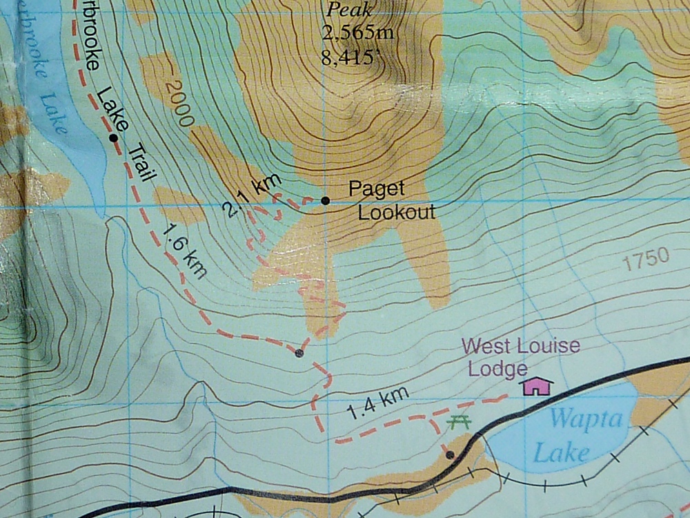
Today, our tenth day of the trip, was a transfer day; we would drive from Field and the Kicking Horse Lodge to Mount Engadine Lodge, outside Canmore. This drive is short enough that we were able to bag a hike that we had been talking about for several years, the trail to the Paget Lookout. It's only 4.4 miles round trip, but the trail gains almost 2,000 feet.
We had our breakfast as the sun was slowly climbing down the mountains into the valley. The yard for the Canadian Pacific Railway, a stone's throw from the Kicking Horse Lodge, was still in shadow.
The parking for the Paget Lookout trail is just 2¼ km west of the Lake O'Hara parking. The lookout trail is a side trail to the much longer Sherbrooke Lake trail. Grizzly bear warnings were posted for the area, so in addition to my carrying bear spray, Joan and I made loud calls every couple of minutes to avoid stumbling into a bear encounter.
You can see that the first leg of the trail is relatively flat, but then begins to climb, and then the Paget turnoff climbs relentlessly. Early on, we saw, without knowing what in the world it was, purple fairy club fungus.
We marveled at the first specimen, not knowing that we would see it several times in the remaining week of our trip.
In this picture Joan is admiring the view while she catches her breath. We were about 15 minutes from the lookout.
We reached the lookout, hot and sweaty from our exertions. The old cabin is still there.
Of course, we stopped to have our lunch at this viewpoint. Here is Joan looking down the valley towards Field.
This panorama reveals most of the rest of the view from the lookout.
At the far left, the Trans-Canada highway begins to curve towards Lake Louise. The valley heading into the mountains, in the center of the picture, holds the road to Lake O'Hara. (With binoculars, you can see the Paget Lookout from Wiwaxy Gap, and vice-versa.)
The cabin isn't locked, although the doorknob came off in my hand the first time I tried to open it. Inside there is a table with a sign-in log, and this plaque on the wall.
Shortly after beginning our return, we paused to admire the geological strata on the opposite ridge, which leads up to Mount Ogden. In particular, look at the erratic folding on the far left, where the darker purple band zigs and zags. It's a long road from being a flat sedimentary deposit to being over a mile above sea level.
Joan enjoys a brief level stretch of trail.
Ten minutes further down the trail we came to this young squirrel, who was clutching a skinny branch as tightly as he could.
On the lower section of the trail, where wet spots occurred from time to time, we often found stunning tall white bog orchids.
Many orchids are definitely not hothouse flowers. We've seen them "in the wild" in environments as spartan as Iceland.
Then we drove on to Mount Engadine Lodge, which I have written about several times before; to easily find those posts, just type 'mount engadine lodge' into the search box below my photo at the top of the blog.
One of the top attractions at Mount Engadine Lodge is reliable moose sightings. Just below the wrap-around deck at the lodge is a mud or mineral wallow that attracts moose almost every night, as well as the occasional deer or elk. The moose, who prefer seclusion, tend to visit the lodge in the evening, as the light is fading, although morning visits are also possible. On our first night we saw this big fellow come in ...
and partake of the waters.
The light continued to fade, although on August 1st at almost 51° North, sunset was much later than it would have been back in Ohio. Finally it was time for bed.