Wednesday, February 19, 2025

Canada 2024: A Busy Start

On July 5th, 2024, Joan and I began our trip to the Canadian Rockies with an early United flight (6:45am). Our connection to Calgary out of Houston United was delayed because, after we'd boarded, the crew discovered that this international flight was the plane's first flight of the day, and a security sweep was required, forcing us all to de-board, wait, and reboard. Still, this was much better than the previous year, when United canceled our booked flight after everyone boarded and got us there a day late.
 
A group of twenty or so from Houston were flying to Calgary to observe and study that city's famous "Calgary Stampede," a multi-day collection of events including rodeos, concerts, etc. They were having a jolly time, although one woman had the flight crew scurrying to find her fancy cowgirl hat -- in the back of a bin above her seat. The front of the plane was entertained, that's for sure.
 
We had to put our foot down at the Enterprise car rental, for they kept offering us an SUV, and we kept insisting that we wanted a car with a trunk. Why? Several times we would be taking a day hike while traveling from one lodge to the next. We did not want our luggage to be visible to anyone in the parking area looking for a profitable vehicle to break into. Finally they found a Nissan Versa, although the car hadn't been washed yet. We took it. Heading west on the Trans-Canada, we stopped at the Kananaskis Visitor's Center to purchase bear spray and a two-day "Conservation Pass," required to park in Kananaskis and the Bow Valley, before reaching our hotel in Canmore. It had been a very long day and we collapsed into bed after dinner.
 
The next morning, July 6th -- a Saturday -- Joan and I drove a short distance east to the parking area for the Heart Creek Trail, arriving at 9:45, which is not bad for a first day. (Click on any image to enlarge.)
The trail meandered to the northeast for a short while.
Taking advantage of a sunny Saturday, families, family groups, and their dogs were out in force. On this stretch flowers were also plentiful, including these longtube twinflowers.
The trail bent 90° and began to wander up the gorge that Heart Creek has cut between Heart Mountain and Mount McGillivray. The 2013 floods scoured this narrow valley.
The trail has been reconstructed but wanders from side to side as the new topography allows. The sheer faces have always been popular for wall climbing.
We continued upstream. I took this photo twenty minutes before reaching the end of the trail.
We reached the choke point of the 2013 flood.
The rock wall and its narrow channel.
Joan inspects.
As I mentioned, family groups were out in force today; this destination, with its pools of water and rocks for sitting, was where they clustered.
On our way back I took this photo of a young lady practicing her "free climbing" -- a friend stands by belaying a rope for protection, but the climber (halfway up) ascends using only natural rock holds.
Joan and I finished the return to the parking area. We continued to the west, towards the Heart Creek Vault, a tunnel carved into Mt. McGillivray's limestone, intended (at first) to store essential documents against nuclear attack. Along this stretch we encountered wood lilies,
yellow salsify,
and a foraging least chipmunk.
Closer to the vault, this web of roots caught my eye.
The bright day was growing hot. Finally, we reached the entrance to the vault.
It's pitch black inside. Joan's headlamp was bright, but mine, an older model (and perhaps with a weaker battery?), was barely adequate for me to shuffle forward carefully. I neglected to take any photos (my camera does have a flash!), but there are images in this blog post from 2018. We snacked in a shady grove nearby, wandered happily a bit further west on the Trans-Canada trail, and then began our return to the car. On the way we admired this spotted saxifrage.
Our day had been quite full. The next day would be more challenging: seeing just how far we could manage on a route that had frustrated us in 2022, climbing the Centennial Ridge trail from the north.

Saturday, February 15, 2025

Puebloan Mysteries: Acoma Pueblo

On May 10, 2024, our Off the Beaten Path group departed Grants, NM, to visit the Sky City of Acoma Pueblo, a settlement perched atop a 365-foot mesa. Arriving promptly, we were among the first to arrive at the visitor's center, sitting near the foot of the mesa. (Click on any image to enlarge.)
All visitors must be accompanied by a tribal guide. A van took us to the top of a road blasted out of the rock in the 1950s.
 
Acoma first appears in historical records in 1539. Several Spanish expeditions followed over the years, culminating in a massacre and enslavement of the Acoma in 1599. Between 1629 and 1641, the Mission Church was built using enslaved labor, 20,000 tons of adobe and other materials, plus Ponderosa pine cut and carried from over 40 miles away. In this photo, our guide is explaining the architecture, art, and grisly early church history.
No photos are allowed inside.
Afterward, we began a walking tour of the Sky City. To make the presence of tourists less intrusive, taking photos of the residents is not done.
There are streets and cross streets.
The mesa hosts buildings old, new, and refurbished. About 55 families live here during the summer, but fewer in winter, so the children can attend school.
Some home renovations are still a work in progress.
Here's a look back as we left the church behind.
There are some vehicles up here. Note the outdoor oven to the left of the car.
To the northwest lies Enchanted Mesa, an earlier abode of the Acoma until erosion destroyed all access to the top.
Zooming in for a closer look ...
This closeup of a knob of "our" mesa shows how sheer the sides can become.
At one location, local artisans had works for sale, including gorgeous pots and other handicrafts. Joan and I needed extreme self-control to avoid accumulating more souvenirs.
 
Here, our group is moseying down the wide "Main Street."
Originally, access to the dwellings was through an opening in the roof, and ladders gave access from the street level.
At a wide intersection we enjoyed some more presentations, but without any photos, I'm at a loss to describe them in any detail. One fellow gave a presentation about his hand-made knives.

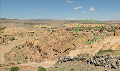
At the end of the tour, we could take the van back down to the visitor's center or clamber down the mesa, using the original route. This was the prospect as we pondered our choice; the visitor's center is in the green circle.
Click on any image to enlarge.
Most of us decided to try our luck with the trail. In the beginning, there were well-worn steps in the rock.
Then things went vertical, and the original hand- and foot-holds were very welcome. John, our Off the Beaten Path guide, did an excellent job guiding and assisting us.
More descent on more accommodating stairs.
Everyone made it safely down, and on our stroll to the visitor's center we admired this rock formation, perhaps a dike. The tip at the top right seemed ready to fall off.
After reassembling at the visitor's center, we left for the Pueblo Indian Cultural Center in Albuquerque. We had an ample lunch there, and then admired the traditional arts of 19 pueblos, such as the San Ildefonso black-on-black pottery. We also watched a traditional dance in a central courtyard.

Afterwards our group checked into the elegant Hotel Albuquerque Old Town, and later had a yummy farewell dinner at a favorite spot for our guide, John
Ninneman. We arrived half an hour early at the restaurant and therefore retreated to the Old Town Plaza, perusing shops and the courtyard of the San Felipe de Neri Catholic Church, built in 1793, and other establishments around the plaza. Also, we had a chance to admire a couple of elegant lowriders before our excellent farewell repast. Early the next morning John ferried the first wave, including Joan and me, to the airport, ending our Off the Beaten Path adventure.
 
If you missed the first post in this Puebloan Mysteries sequence, it's here.

Friday, February 7, 2025

Puebloan Mysteries: Hubbell Trading, Window Rock, El Morro

On May 9th, 2024, our Off the Beaten Path group filled the day with a visit to three intriguing sites: the Hubbell Trading Post, the Navajo Tribal Headquarters, and the El Morro National Monument. There would be a few hours in the van, as well. (Click on any image to enlarge.)

Hubbell Trading Post.
The Hubbell Trading Post, operating since 1889, is the oldest trading post within the Navajo Nation.
We parked near the original complex John Hubbell built.
This view includes the barn.
A National Park ranger gave us a tour of the interior of the Hubbell residence. A portrait of John Hubbell hangs in one hallway. He was noted for his fair dealings with the Navajo and hosted many visitors, including Theodore "Teddy" Roosevelt in 1912.
The trading post was sold by family members to the National Park Service in 1967, and the home has been preserved. Here's the main hallway.
Many famous persons of the era passed through, and some stayed a while. In this photo of a bedroom, you'll note the conte-crayon portraits by Elbridge Burbank. (Click on images to enlarge.)
They even owned a piano!
Outside, we noted the guest hogan (eight-sided building) used by researchers and artists.
Our group spent time in the separate trading post store, where visitors can peruse various Navajo handiwork, ranging from children's toys to spectacular classical rugs. On the outside, Joan and I also enjoyed a pair of supervising (well, napping) owls.
Eventually, it became time to leave, and we were on our way to Window Rock.

Window Rock.
Window Rock is a name for both a geological feature and the Navajo Nation's capital. First, we parked at the Window Rock Tribal Park & Veteran's Memorial. Three flags fly at the parking area: Arizona, Navajo, and USA.
The Veteran's Memorial, established in 1995, was designed as a circle with walkways oriented to the four compass points.
The park naturally gives a place of prominence to the Navajo Code Talkers of World War II. It was our first stop, traveling clockwise.
It's a dramatic history ... click on any image to enlarge.
There seems to be a tradition of leaving coins at the memorial's base.
Continuing along the walkway, the name-bestowing window rock grew larger and larger.
A closeup using zoom. Walking to, above, or upon the Window is strictly forbidden.
Continuing around, we walked respectfully through the remembrance of Navajo veterans.
After leaving the memorial, our group relocated to the Navajo Nation Museum. The sidewalk was lined with vendor's stalls, but our time was limited, so Joan and I entered straight away. The exhibits include Navajo art of various genres, covering many eras of Navajo history. A topic of particular interest to us was the "Long Walk of the Navajo," a deportation by the United States of about 10,000 Navajo to eastern New Mexico, requiring some 50+ different forced marches from 1864-1866. During the march and following internment, a third of the population died from starvation (the new land was unfarmable) and disease. In 1868, the Navajo were allowed to return to their homeland, as negotiated by General William Tecumseh Sherman, and on exhibit at this museum is one of  two surviving original copies of the Treaty of Bosque Redondo.

After a big lunch nearby, we clambered into the van and headed for El Morro National Monument.
 
El Morro.
The El Morro National Monument is sometimes known as the Grafitti Rock. Indigenous peoples, Spanish explorers, and American adventurers have all carved inscriptions on the sheer bluff sides. After a stop at the visitor's center, I took my first photo.
There are trails to follow to inspect the "graffiti," but some are currently closed.
Our first major stop was at the pond when heading counter-clockwise from the visitor's center.
Approaching the pond, tucked in a shaded corner.
In season, it must be a charming waterfall.
Joan and I continued on and began encountering the inscriptions/graffiti. Here, we see indigenous petroglyphs (Click on any image to enlarge.)
More work was left by the Spanish and Americans. Some of the script is elegant,
Block letters from 1859. (All graffiti after 1906, when the site became a national monument, has been erased.)
Spanish script from 1709!
At the Inscription Rock, a cluster of rectangular signatures appeared, as if planned.
Soon, Joan and I reached a point where we decided to turn around; we wanted to visit the ancestral Zuni pueblo atop the plateau. Returning the way we'd come would be the shorter way; we'd been told that further along the trail was closed. After climbing various staircases, we found the view from the top, about 500 feet up, was expansive.
We soon arrived at the Atsinna pueblo.
The focus now is more on preservation and less on excavation.
Just beyond, the trail was in need of repairs.
I took a few steps forward and took another panoramic shot, bringing the valley floor on both sides into view.
Then it was time to turn around. A rock wren was supervising us.
After gathering at the visitor center, our group drove on, regrettably passing by the El Malpais National Monument -- lava flows, cinder cones, lava tube caves! But there are only so many hours in a day. We settled down in Grants, New Mexico, for dinner and to spend the night.