Thursday, August 29, 2024

Hiking Canada 2023: The Paint Pots & Nearby Trails

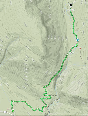
On July 27, 2023, Joan and I set out for a less ambitious hiking day than yesterday's hike towards Ball Pass. We drove down Highway 93 again, this time to the parking area for the Paint Pots. Here's an overview of this day's hiking: (Click on any image to enlarge.)
A trail through the woods takes you from the parking area
to a bridge over the Kootenay River.
It's an impressive span for a hiking trail, but then, the pots are a popular hike.
The view from the bridge is impressive.
The
pots are formed by the accumulation of iron oxide around the outlets of cold mineral springs. Indigenous peoples used the ochre for paint, and settlers mined the ochre clay until the late 1920s. It will stain anything it touches, and the mushy route to the pots is built on it.
Here, Joan inspects the pots.
We continued our exploration on the Ochre Creek Trail, meeting
several other groups of hikers along the way until its junction with the Tumbling Creek Trail. We took that trail and soon encountered a bridge over Ochre Creek.
On the far side we took a break.
Joan and I shared some cookies, and discovered some "hidden" maintenance equipment, including chainsaws, stashed in the brush. The sky was clouding up, so we decided this was a good point at which to turn around. The return over the bridge was as exciting as the going out:
Along the way, we encountered this three-toed woodpecker. It favors areas with lots of dead trees, and that's where we saw this one:
Darn well camouflaged!
Also, the ubiquitous fireweed.
A spotted longhorn beetle; they favor plants in the Apiaceae family for their pollen and nectar.
And here's a "pale beauty" butterfly!
There's a lot to see if you take the time to look.
 
At the junction with the Paint Pot trail, Joan and I kept left and explored the trail towards Marble Canyon for a while. (It was also a way to avoid slopping through the ochre clay of the Paint Pot trail again). Here, we again encountered fallen trees that required negotiation: shall I go around? Over? We reached the junction without mishap.
Having seen Marble Canyon two years before, Joan and I decided to return towards the Paint Pots. We were rewarded with a scenic riverside trail.
And recrossed the bridge to the parking area.
Then it was time to return to Storm Mountain Lodge for dinner and packing -- the next day, we'll slowly make our way, with several stops, back to Calgary and the airport hotel.

Monday, August 26, 2024

HIking Canada 2023: Hawk Creek / Ball Pass

For July 26th, 2023, Joan and I chose the Hawk Creek / Ball Pass hike. We tackled this route back in 2009 (a very brief account is here) and had observed fresh growth after the catastrophic fire of 2003. Now, it was time to see how it looked after another fourteen years. The trail starts in the lower left corner of this map -- the first hundred yards or so are along the berm of Highway 93. (Click on any image to enlarge.)
We had to arrive early, because the parking area is crowded these days with hikers tackling the popular Rockwall route on the other side of the valley. The drive was a bit longer than in 2009 because we were leaving from Storm Mountain Lodge rather than Kootenay Park Lodge, which has apparently turned into a dismal dump -- and refused to return a $500 deposit we couldn't use because of COVID, even after Consumer Protection BC tried to intervene. They even refused delivery of a FedEx package! (There had been two changes of ownership.) The difference was only 15 minutes, but these delays add up.
 
Starting out, we saw both new growth and bones of the old forest.
Twenty minutes up the trail, more of the same.
Dead trees that had fallen across the path slowed us down. Many were heavily charred, and brushing against them meant smearing our garb or packs.
Almost always, tangled new growth prevented us from going off-trail to circumvent the obstacles. Each one needed to be studied to decide: can it be lifted, if I find a decent spot to grab? Is it high enough for us to go under it? Is it low enough for us to go over it? Joan and I were often on our hands and knees. The Parks staff had cleared earlier casualties with chainsaws,
but the corpses had continued to fall since their last visit. We learned how to  manage, but it slowed us down. This photo doesn't do justice to the variety of obstacle positions, condition, and sizes.
Over or under?
Taking in the view.
Occasionally there was a bloom, such as this lanceleaf blanketflower.
Ascending the valley, looking ahead. Hawk Creek is in view.
We began to encounter other hikers, including those catching up to and passing us. A young couple was descending from Ball Pass, having been around a month so far on the Great Divide trail. (Click on the image to enlarge.) I marveled at how modest their equipment load appeared to be for such a trek.
As Joan and I climbed, the terrain became rockier and the wind picked up. Here, Joan is crossing a side stream.
Looking back, we can see we've gained some altitude.
Ahead is a steady climb and a narrowing valley.
Here, we can see a sharp transition from burnt to untouched forest across the way.
Old, bleached roots are the same color as the rocks.
The walls drew closer.
More hikers passed us when we stopped for a snack. Joan and I forged on, hoping to reach Ball Pass despite the many obstacles we'd encountered. Another fifteen minutes ... another ten minutes ... we finally decided that we had to turn around if we were to show up on time for dinner at Storm Mountain. On our descent, I snapped this photo, which included aging fireweed.
Later on our return, a Rocky Mountain Maple. This species is known to favor fire-disturbed sites: that fits!
And then, Solomon's Plume, with berries.
As we grabbed another snack, a young fellow came up the trail. He had ambition -- first reach Ball Pass, and then scramble up Isabella Peak (summit at 9639' or 2938 m).
As many Canadian hikers seem to do, he'd gotten a late start, and even forgot his sandwiches. Yikes! We hope it turned out OK.
 
Back at the start, Joan and I found the Floe Lake parking area saturated, with several cars parked on the berm of Highway 93. Although we hadn't reached Ball Pass, it had been a grand adventure. But if you go, plan for burnt timber strewn across the trail.

Friday, August 9, 2024

Hiking Canada 2023: The Inkpots, and Beyond!

On July 25th, 2023, Joan and I aimed for a hike to the Inkpots and beyond. We drove back down to Highway 1A from the Storm Mountain Lodge and pulled into a parking area just east of the Moose Meadows. This was a strategic choice; although it would add some distance to the hike, it avoided the hordes and impossible parking at the Johnston Canyon trailhead. (Click on any image to enlarge.)
The first stretch of trail was wooded, wide, and climbed gradually.
Our "secret" trail began climbing in earnest, joining the Inkpots trail after 3.2 km, or 2 miles. By avoiding the Johnston Canyon section we had yet to see another soul.
The next stretch of trail was wider, and rolled up and down with a final descent into the valley holding the Inkpots. This sign greeted us on arrival.
Looking down as we approached the valley floor.
Here's one of the larger ponds.
At the bottom, I took this video of the huffing and puffing at a pond's bottom. The upwelling keeps the ponds at a constant 4° C (39° F).

Good viewpoints are spread around the lower reaches of the valley.

Joan and I felt encouraged to hike beyond the pots for a while. We began walking up the valley, and butterflies appeared. This specimen might be one of the several possible sulphurs (clouded? pink-edged? orange?) or a Moorland Clouded Yellow.
The route was rocky but plain to see.
This white admiral needs to be better camouflaged!
A few people had congregated at the bridge over the river but were reluctant to attempt it. The wooden structure consisted of two boards on edge, not flat, with only one handrail, and steps up and down at each end.
The bridge is circled in yellow.
We crossed without mishap, but nobody followed. On the other side we met this battered sign.
At first, we wandered through willows and other brush as the gap between us and the river on our left widened. Then we climbed to a higher level and finally encountered another hiker. Shortly after that, we arrived at campground Jo 9, also known as Larry's Camp Campground. It consisted of ten campsites and an outhouse. A hop and skip later, we crossed a bridge.
We were sitting at a major intersection for back-country exploration.
We found a congenial spot under a tree and had our major lunch. While here, Joan and I saw plenty of overnight back-country campers pass by: an enthusiastic solo woman, a youth group, a solo guy, and yet another group.
 
Retracing our steps to the Inkpots seemed to take half the time it did walking out -- a familiar experience when traversing an area for the first time. However, climbing back out of the Inkpot valley was a heavy-breathing ascent. Then the spur trail to Moose Meadows seemed to go on and on. Eight km or five miles out, same way back. A 10-mile hike ... not bad!

This map contains, in condensed form, our entire route. (Click on any image to enlarge.)

Wednesday, August 7, 2024

Hiking Canada 2023: Moraine Lake Highline

July 24, 2023, was our transfer day away from Moraine Lake, but Joan and I didn't need to leave until 2:00, so we decided to take a stroll on the trail paralleling the access road, the Moraine Lake Highline. It's open to both hikers and cyclists. (Click on any image to enlarge.)
We aimed to reach a fabulous viewpoint with panoramic vistas that hover over the Moraine river/creek valley. We hadn't made it that far the previous year.
 
At times, we could look toward the Consolation Lakes valley.
Early on there was some damage to the trail, easily walked around.
The route parallels the road, sometimes closer, sometimes further away.
Open areas speckled the forest as we climbed towards the viewpoint.
Some of the flowers were still early in their season.
We enjoyed a shifting, always panoramic view.
Looking back the way we'd come.
During our return we encountered other hikers and were passed by a mountain bike. Joan and I had a light lunch at the lodge, where the crowds never abated. Moraine Lake is a perpetual motion machine.
Then it was time to depart. Getting on Highway 1A, the more scenic route than the Trans-Canada (Highway 1), consumed extra time due to construction at the intersection. On the 1A, we encountered a myriad of motorcyclists, including two towing miniature classic cars! To reach Storm Mountain Lodge, our base for the next four overnights, we turned south onto Highway 93, which was extra busy with car and double-trailer truck traffic because of repaving work on Highway 1. This rerouted mob was climbing towards Vermilion Pass (~5600 ft.) and bound for Radium, Windemere, or as a long detour to Golden. (Click on the image to enlarge.)
But we had enough time and had no problem cleaning up for our dinner reservation at Storm Mountain.
 
The next day, we'll tackle a back door to the Inkpots and beyond.