In this map our start is in the lower right corner, and the first two stops are shown, Loch Droma at the location symbol and Corrieshalloch Gorge in the upper left.
When we stopped at Loch Droma Jonathan and Louise brought out spotting scopes.
The sharp-eyed among us spotted a Black-throated Diver (Arctic Loon) in the loch, and as it began to swim, its mate and a chick came into view. This is the best photo from my point-and-shoot, zoomed in and heavily cropped! (Click on the image to enlarge, and look between the two trees.)
Louise spotted a golden eagle in the distance above the ridge of Sgurr Mor, and we watched it being harassed by a raven.
It was a short drive on to Corrieshalloch Gorge. From the parking area we could see down a green valley to Loch Broom.
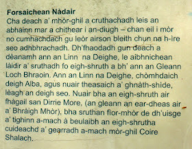
A descriptive sign about Corrieshalloch.
After a few switchbacks down the side of the gorge we arrived at the footbridge: limit six persons at a time.
Here's a closer look at the bridge.
 |
| No jumping up and down, please. |
Jonathan led us along the loop trail on this side of the gorge.
On the far side was a typical Scottish scene of demarcated wildness bordered by clear-cutting and tree plantations.
Our path returned to the parking area, where Jonathan, Louise, and Jim popped open the back of the van and plied us with various biscuit ("cookie" to us Yanks) and drink options. They were wont to do this all through the trip, and we never complained.
A sign explained the formative geology of the phenomenon.
 |
| It took a long time. |
Our snacking finished, Jim drove us northward down the valley of Loch Broom, and after a brief stop in Ullapool we continued north to Knockan Crag, a famous geological site. The rugged highlands were on full display.
A sculpture on the path displayed the geological layers that had caused disputation, through the paradox of having older rock on top of younger rock. (The layers are named but you'll need to click on the image to see 'em.)
It was a brief walk to the exhibit,
which included statues of advocates of the two sides of the argument, which were, 1) it must be a mistake, older rocks can't possibly be on top of younger ones, and 2) we can't tell you why the layers are "flipped," but the aging is correct. Although the theory of plate tectonics was still decades away, the conundrum was settled in 1907 by proposing a thrust fault that had pushed older rock up and over the younger.
We got our first good look at a red deer, a one-antlered male. Our group had been in Scotland briefly enough that this still caught our attention.
Then it was up to the ruins of Ardvreck Castle, at 58º North latitude, the same as Juneau, Alaska.
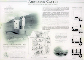
The explanatory sign.
A closeup. The abandoned castle was badly damaged in a 1795 thunderstorm.
Not much remains of the backside. Susan, from our group, is waving from the grassy edge.
The view from the castle mound back to the lake includes the ruins of Calda House, built by the MacKenzies in 1726, possibly using stones from the castle, and which burned down in 1737. (The MacKenzies backed the losing side in the 1745 Jacobite uprising, and their estates were seized by the Crown. Not a lucky bunch.)
On our way back to the van we did some serious botanizing which included orchids. Here Jonathan lends his expertise.
Spoiler Alert. If you are thinking of signing up for this NatHab trip, don't follow this link to a spoiler regarding our visit to Ardvreck.
From Ardvreck Jim drove west to Lochinver, where we dropped off our luggage at the Inver Lodge Hotel (a Telsa Model S in the parking area caught my eye) before heading up a long, meandering road to Clachtoll Beach. The beach has an extensive campground and is very popular, particularly on a hot (for Scotland) and sunny day. A small promontory separates a narrow beach, in earlier days used for landing fishing boats,
and the main, recreational beach.
Jagged rock formations guarded the southern end of the beach inlet. Note the hiker on the skyline.
With our binos Joan and I scanned the waters, spotting a distant bird or head of a seal, and then we explored the tidal pools. As did the oystercatchers.
In one pool we discovered possible sea slug (a widely used term for marine gastropods that have no shell, or appear not to.)
A fuzzy closeup.
 |
| Not a piece of kelp. |
 |
| The view from our window. |
Tomorrow: the isle of Handa.


No comments:
Post a Comment
Comments may not appear immediately as they are moderated by the author to eliminate spam. Please, no commercial links!