The next day, July 31st, was our last at Lake O'Hara for the year. Fortunately, we had arranged to take the afternoon bus out, so we had time for one more hike. This time, we would climb to the Opabin Plateau and "mess around" on the many trails there on our way to Opabin Lake.
We took the West Opabin trail, which offers much more scenery than the East trail. Early on we were offered flowers again, this time side-by-side arnica and columbine.
The West Opabin trail quickly leaves the lakeside forest and begins to climb up a rocky face of the plateau. Looking out, even from the low beginnings of the climb, is worthwhile.
On our way up we encountered this bladder campion.
We first went to the Opabin Prospect, although we took the longer (counterclockwise) direction from the West Opabin intersection (see map below.) However, the video I took there didn't turn out well, so I have no pictures from this year to offer. But the first half of a post from last year has excellent pictures and information about both the West Opabin climb and the Prospect.
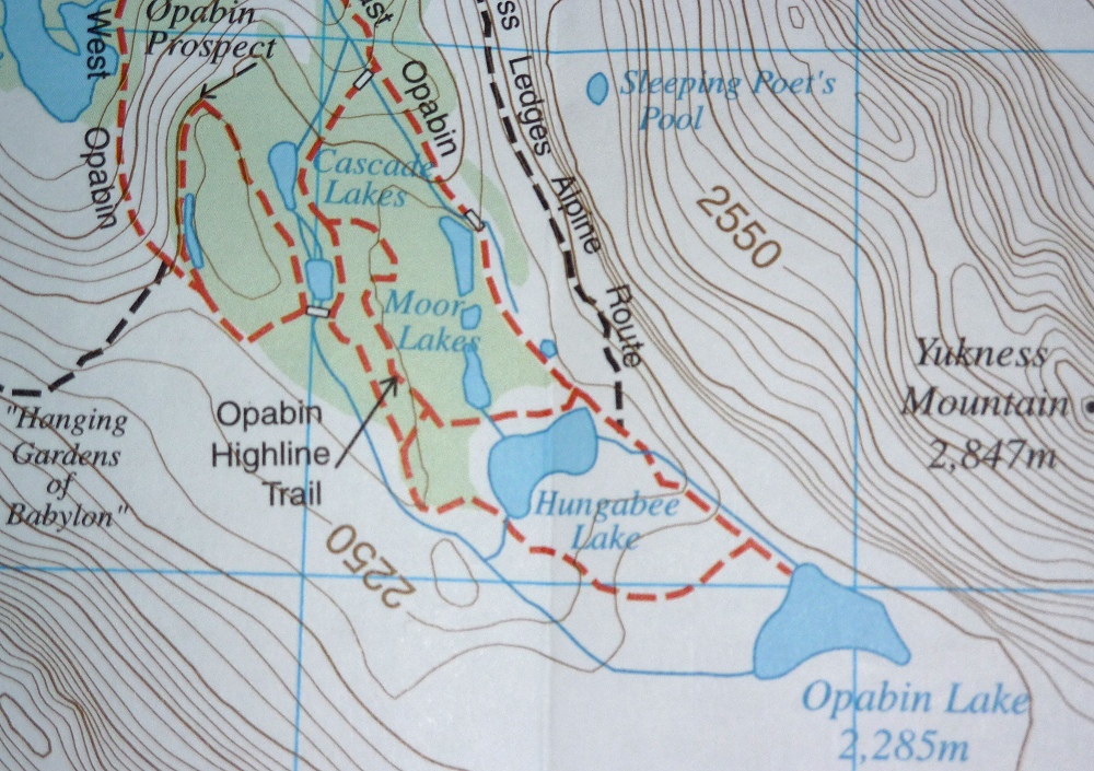
Now it's time for a map, to help me explain our peregrinations around the plateau.
In this picture we are approaching the Cascade Lakes.
We spent a while at these lakes watching the wildlife. There was a pair of common goldeye ducks diving, resting, and sunning.
And a sandpiper!
We crossed over to the Opabin Highline trail, to head up towards Hungabee Lake and then Opabin Lake. About 40 minutes later we encountered a pika by the side of the road.
The highline trail runs into the East Opabin trail just before the Yukness Ledges trail, a busy stretch of intersections. Just beyond, when you are committed to reaching Opabin Lake (no more intersections, except the return), a small portion of the trail has been rerouted. Signs and trees block the old path.
Snow avalanches over the winter had decapitated some of the trees.
We came over the top of the moraine and down to the shores of Opabin Lake.
The lake was much fuller this year than last, as the next photo, from September 2, 2011 shows. I was standing on lakebed, and more dry lakebed is visible in the photo.
Joan and I lunched on the shores of the lake, very much where this year's portrait photo was taken. There was a gray-crowned rosy finch foraging on the rim of the lake and in a feeder creek, and I caught some of its rapid hunting of water bugs in this video.
We weren't the only ones admiring the view.
There were a couple of marmots browsing on the greenery near the lake, but not close enough for a good photo.
Then it was time for us to march back to the lodge to catch the afternoon bus down to the parking area. My parting photo from Lake O'Hara is the view from the top of the moraine, looking away from Opabin Lake.
From the parking area it was a quick drive back to the Kicking Horse Lodge and the Truffle Pigs Café.
Tomorrow we would explore the trail, new to us, to Paget Lookout.
Our next hike was climbing to Wiwaxy Gap and following the Huber Ledges. I documented this in detail last year, so this time I took pictures of whatever caught my eye.
Early morning photos of Lake O'Hara are common, but I can't resist sharing this one with you, taken on our way to the Wiwaxy Gap trail junction.
One of the joys of an early-season visit is the profusion of flowers making the most of a short growing season. In this next photo, spot the beardtongue everywhere in the right-hand third (click to enlarge). Also note the alpine trail blaze in the lower right-hand corner; two yellow bars on a blue field.
And then there were these, stonecrop and fringed grass of parnassus.
On an ultra-steep trail such as Wiwaxy Gap, you will pass some people and be passed by others. A cheerful word, even if you're out of breath, and spectacular views remove any embarrassment.
We continued to move higher, taking frequent lung breaks. Another half hour, and we were able to see Sleeping Poet's Pool, which we had visited two days before. This picture was taken at full zoom.
We reached Wiwaxy Gap, cooled down, and caught our breath. I didn't take any photos from the gap this year, but this is such a milestone that it must be noted, so I'll include the video I shot from Wiwaxy Gap last year.
Then we began to traverse the Huber Ledges. We nearly ran over a hoary marmot who was intent on eating the dirt in the trail, perhaps for minerals. As long as we stayed more than three feet away he ignored us. After a moment of observation we were forced to disturb him, in order to press on.
Drawing closer and closer to Lake Oesa, we came to a spot that offered us an excellent angle for scanning, with our binoculars, the tilted tableland that forms the corner of the Yukness Ledges trail.
Even on the high ledges we would run across flowers, such as this moss campion, particularly on damp spots where water would be running down from the heights.
This picture, taken as we drew closer to Lake Oesa, shows not only the lake itself but the extensive rocky shelf on its shore. This is a favorite lunch stop and picnic ground, with room to absorb dozens of people. Click to enlarge the photo, and if you squint, you might be able to spot hikers scattered about.
Researchers from the University of Alberta and the University of Calgary are conducting various studies in the Lake O'Hara region, both geological and hydrological. We've seen them up at Opabin Lake, and today some were out on Lake Oesa. Two were in an inflatable craft -- how would you like to carry that up to the lake?
This fellow was definitely not a researcher. He also didn't stay in the lake very long.
We left Lake Oesa by the outflow, planning to take the initial section of the Yukness Ledges trail, and then take the Victoria Lake cutoff to rejoin the Lake Oesa trail for our return.
At the foot of the outflow another team was taking some measurements.
In the next photo, we're looking forward on the cutoff trail, near the unnamed pond in the map above.
The clouds threw down rain and hail twice on our walk back. The hailstones were large and fast enough to hurt when they hit. The white spots you see in this picture aren't flowers, they are hailstones.
Here is a closeup.
Sometimes the smaller hailstones would be stuck in the fingers of a tree.
Twice we sought shelter under large trees when an intense shower swept up the lake, a strategy that helped. We sought a tree on the side of the trail with a dry, or nearly dry, ring around its base. Good ones were not common, and the Lake Oesa trail has many sections open to the sky, so we had little shelter from the first storm. Nonetheless Joan and I made it back to the cabin without any bruises from the hailstones, and ready for dinner.
Our training goal for the next day, compared to the preceding days, was a longer hike with fewer steep sections. We decided on going to Linda and Cathedral Lakes, but, because we were not going as far as Monica Lake, which we did the previous year, we started the hike from our cabin instead of taking the bus to the Linda Lake junction.
The first trail segment is called the Morning Glory Lakes trail, and it winds for a long, long time (especially on the return) through the forest on the outskirts of Odaray Mountain.
After a while the path goes around a shoulder and begins to descend to the Morning Glory Lakes. Here is a picture taken as we drew closer to the middle lake.
We continued down and around the left side of the lake, encountering a rich grove of flowers in that sunny, moist environment.
The trail was briefly in the open. Cathedral Mountain ruled the horizon.
We soon faced a choice between the Linda Lakes Beeline trail, which switchbacks directly over the moraine in the photo above, and a more circuitous route via the Morning Glory Valley.
We intended to resolve a mystery, so we knew we were taking the Morning Glory Valley connector. There is a Linda Lake Circuit, a way to circumambulate the lake. This explanation may be clearer if I first provide a map:
The link on the east side of the lake, connecting the northern and southern arms of the Linda Lake trail, had apparently disappeared in our earlier visits. We felt this way because the trail sign where the southern arm and the eastern link should join points only down the southern arm, and a log or two crosses the unlabeled, faint link trail heading north, as if that path is considered 'discontinued.' But we thought we had seen a different indication, last year, at the sign at the junction of the eastern link and the northern arm. We were going to revisit that spot and take any trail south, no matter how tenuous, to discover what now existed.
Arriving at the northeast junction, we inspected this sign. It shows the Linda Lake Circuit heading both west and south.
We headed south. On that narrow trail we had to brush past tree limbs a few times.
We were definitely making our way down the east side of a lake.
As you can see from Google Maps, the main body of Linda Lake is connected to this long, skinny arm.
We paused at a good place for a rest stop. I found the clarity, aquamarine color, and hypnotic waves of the lake here worth a short video.
Clarity, Color, and Waves on the East Side of the Linda Lake Circuit.
The arm of the lake then disappeared, except for perhaps in wetter seasons. We walked through a flowered meadow, and soon arrived at the trail sign for the southeast corner of the circuit.
As you can see, the sign indicates only a passage to the west on the Linda Lake Circuit, with no mention of the east link. A log still blocked the lightly-traveled link. We had resolved the question of whether the east link still existed -- it does -- but not the question of why it seems to have been wiped off the books at this intersection.
After a short walk to the west, we arrived at the shores of Linda Lake. This point gives a wide view of the main body of the lake.
As we made our way along the south shore, I saw this patch of moss, a sapling, and a paintbrush just offshore, and something in its existence in an environment of rock and water appealed to me. It's almost an aquatic bonsai.
The trail passes near the edge of the lake, which can make the ground soft, and then starts to climb a small, rocky moraine. The view of Linda Lake from its southwest corner is one of the best you can get without climbing a mountain.
The structure of the rock pile here -- not too large, not too small -- makes it a favorite of pikas.
We decided to lunch here, and saw a wonderful floor show, including this golden-mantled ground squirrel. He has stuffed his cheeks to overflowing.
Our pika friend stayed busy harvesting as well.
OK, one more pika picture. When they emit their clear, carrying, high-pitched "eeeeep!", they put their whole body into it:
After lunch we marched on, taking the Cathedral Lakes trail, which continues up the Duchesnay Basin.
We paused at the outflow of the largest of the Cathedral Lakes; I took this picture on a footbridge over Duchesnay Creek.
Then it was time to turn around and begin the long walk back to Lake O'Hara. At the moraine where we had eaten, this time there was a pair of hoary marmots to greet us.
The previous winter's deposits were melting in the late July sun, and pouring off Odaray Mountain/Glacier.
Then it was time for the long slog back along the Morning Glory Trail. It was good training; our feet were sore by the time we reached our cabin, but we had been privileged to see gorgeous lakes, flowers, and animals today, under perfect skies.