
The Columbus Metro Parks system has many parks and sponsors many programs, one of which is called Metro Five-0, activities for adults 50 and over. These activities run a wide gamut, from casual workshops on writing about nature to observing butterflies to canoeing and hiking.
Our favorite spot for nearby hilly hiking is Clear Creek Metro Park, just under an hour away. Through the Metro Five-0 program Joan and I can take guided weekday hikes into areas of Clear Creek that are unmarked and normally off-limits. So far I've been on three of these Metro Five-0 Clear Creek hikes, and Joan's been on more. I have enough photos to lightly document the last two.
Ice Cave/Jan 18
Here our Five-0 group is gathering on a chilly but sunny January 18th for the Ice Cave hike. This parking area is at the office for Clear Creek, the white building.
 This hike generally has a broad trail, which in one spot blends into the landscape a bit, and has a couple of intersections. This photo is actually from the return leg, but it will suffice to illustrate.
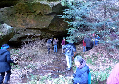
 Here we have arrived at the mouth of the small gorge where the ice cave lives.
 We have stumbled into a perfect day for the ice cave. There is a steady drizzle of melt water, but the cold snap earlier in the week has left plenty of ice.
 Pre-registration was required for this hike, which has a maximum number of participants, and you can understand why when people are maneuvering for a better look at the ice formations.
 This is one of the views looking out from the cave into the light.
 The combination of falling water and cold temperatures has laid a thick skin of ice over the sticks and stones.
 This shot has a more accurate coloration.
 When inspected more closely, the wet ice resembles a congealed flow of shiny glass.
 Some small critter left his or her skull here.
 Then it was time to hike back. The fellow in front of the group in this photo, wearing a cap, is Bob Neinast, or "Barefoot Bob". (Click on the photo to enlarge.)

Winnowing Rock
We returned for another Metro Five-0 hike on June 7th, this time to Winnowing Rock. This hike didn't require pre-registration, but the turnout was modest anyway. Here we have just departed from the parking area, crossing Clear Creek, which is muddy from heavy rain the night before, which might have suppressed the turnout.
 We proceeded at a relaxed pace, observing the landscape and listening to the guide, Marcy, point out features and flora and answer our questions. Here we have paused to admire some blooming mountain laurel.
 There was even more just down the road.
 I zoomed in for a closeup.
 Early on we passed a beaver dam.
 This picture gets a little closer (click on the image to enlarge).
 The damp environs of the first part of the trail supported ferns, whose spores Marcy is describing here, as well as the difference between spores and seeds. Seeds contain food as well as the plant embryo, spores do not.
 There was also a lush crop of skunk cabbage, which fortunately bloomed long ago, in January and February.
 One spot hosted some fire pinks.
 The low-lying portion of the hike was near its end at Emily Lake, known to Google Maps as Benua Lake. The Beck and Benua families donated much of the land that became Clear Creek Metro Park.
Our favorite spot for nearby hilly hiking is Clear Creek Metro Park, just under an hour away. Through the Metro Five-0 program Joan and I can take guided weekday hikes into areas of Clear Creek that are unmarked and normally off-limits. So far I've been on three of these Metro Five-0 Clear Creek hikes, and Joan's been on more. I have enough photos to lightly document the last two.
Ice Cave/Jan 18
Here our Five-0 group is gathering on a chilly but sunny January 18th for the Ice Cave hike. This parking area is at the office for Clear Creek, the white building.


Winnowing Rock
We returned for another Metro Five-0 hike on June 7th, this time to Winnowing Rock. This hike didn't require pre-registration, but the turnout was modest anyway. Here we have just departed from the parking area, crossing Clear Creek, which is muddy from heavy rain the night before, which might have suppressed the turnout.


From the dam visible in the above map, this is the view.


A foundation is all that remains of the other cabin. Rumors say that this cabin hosted celebrities and wild parties many decades ago.


