Pages

Monday, February 27, 2023

Back to Canada: Continental Divide, Marble Canyon, and Wapta Falls


After a good overnight rest at Storm Mountain Lodge, our first hike on July 23rd was the gentle trail at the continental divide, the boundary between the provinces of Alberta and British Columbia. (Click on the image to enlarge.)
I didn't take any photos there, but Google Street View provides an assist:
The trails here show how the forest has regenerated after a 1968 fire. The 1.6 km loop leaves from the left-hand side of the parking area, and it needed maintenance. Joan and I traversed it without finding much of interest. The shorter loop, which is handicap-accessible, had interpretive signs. The highlight of this portion was a Cooper's hawk, guarding her nest and perching on a branch to screech at us every time we came too close or even looked in her direction.

From the divide, it was a short drive to Marble Canyon, a popular spot with crowded parking. As we followed the trail upstream,
the canyon became deeper and narrower, and the water faster.
Sometimes it looked as if a giant axe had split the rocks.
The varying depths and angles created different lighting, including the occasional rainbow.
Some folks enjoyed going beyond the fences.

After this hike, Joan and I decided to return to Storm Mountain and spent the afternoon resting or taking local walks. It was our last night there, and we settled on tomorrow's goal: a trip to Wapta Falls before turning around and motoring east to Moraine Lake Lodge.

The next day, July 24th, we set out for Wapta. When traveling westbound, as we were, the route is tricky. One must leave the Trans-Canada on a small side road, pass under the highway, and proceed down a gravel route to the trailhead. As Joan and I approached the critical area, there were construction signs, and workers milling about. We missed the turnoff, and the next chance to turn around wasn't until a rest area much further down the Trans-Canada. Click on the image to enlarge -- Google Maps estimates we spent at least an hour and a half on the road. Whew!

Wapta Falls is a popular destination, and attracted lots of visitors today, from speedy young adults to meandering family groups. The trail was easy to follow and without tricky footing until it reached the falls.
The route began to drop, and soon we were abreast of the stream.
A gentle but obscure switchback reaches the bottom of the falls, but many visitors either didn't see it or preferred to plummet down a steep slope without handholds to reach the bottom. Joan and I took the steep way down, where there were gravel beaches to wander on and logs to sit on while eating lunch.

As an exploratory gamble, on our return we began with the switchback, and found it deserted and congenial all the way back to the top of the falls, where we retraced our steps to the car.

After a few miles, the traffic came to a stop. There was no sign of an accident, but some people had left their vehicles to wander about and catch the air. Then we began to inch forward. Turning around was not an option; we would have had to drive around half the province (a mild exaggeration). There are precious few routes through the Rockies and the continental divide.

The creeping grew progressively better, but it was still creeping. We wondered, had there been an accident, or, given the volume of traffic on a sunny Sunday on a two-lane road, were we beyond the carrying capacity of the highway? I thought of the climb up Kicking Horse Pass; even one semi-truck struggling up that incline would reduce the volume by half!

Fortunately, the congestion let up as we squeezed through Field. But our goal, Moraine Lake Lodge, lies in a permanently congested area it shares with Lake Louise. This summer (2022), private vehicles were turned around from the 19-mile road to Moraine Lake after 4am: you had to book a shuttle. But, as Lodge guests, our exalted status took us past the traffic guards and their orange-and-white sawhorses -- after driving to and from the Lake Louise parking, for left turns onto the Moraine Lake road are not allowed.

What a day! But now we were at Moraine Lake, and ready to indulge in some serious hiking on the morrow.

Thursday, February 23, 2023

Back to Canada: Stanley Glacier Hike

On July 22nd, Joan and I drove across the continental divide (just a few  miles away!) to join the guided Stanley Glacier Hike. The trail is open to the public, but by joining this hike we benefited from commentary and interpretation. The Parks Canada website warns,
 
From the Stanley Glacier parking, the first 4 km of the trail are gently graded on well maintained, packed dirt trails. The final section of the trail includes 800 m of rough trail and 200 m of walking on rough and loose rocks. This hike is not advised for people with recurring knee, back, or ankle injuries. 
 
As you can see from this image, the hike starts with switchbacks. Your definition of "gently graded" may vary from that of Parks Canada, but it's not extreme.
Some early sections were consumed by forest fires in 1968 and 2003, and the lodgepole pines, willows, and other trees are slowly growing back. In this photo, the brownish band halfway up the prominence (click on the image to enlarge) hosts some of the fossils for which the area is famous, along with the Burgess Shale and Mt. Stephen.
On the way up, our guide called a couple of stops, for a breather and some information about the critters of the Cambrian Period.
After we climbed up to the lip of the hanging valley, the trees were taller and the brown band more prominent.
Our group paused for another break before crossing the exit stream. One of our band of hikers ... not Joan! The photos of us didn't turn out well.
The route began to rise on one side of the valley. Here's a peek looking back. The footing was getting rocky.
Across the way, the summer melt running off the glacier formed a waterfall.
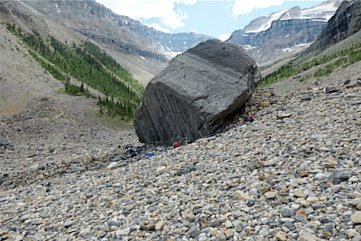
At lunchtime, we left the path and settled down next to a large boulder. We had time to spread out and look for fossils, primarily trilobites.
The sky began to cloud over. Our guide decided it was time to start our return, and we kept our rain gear handy. A few moderate showers passed through as we walked down the valley, but thankfully, no thunderstorms erupted.
Joan and I arrived at the parking area worn out but happy.

Sunday, February 19, 2023

Back to Canada: Castle Mountain Lookout

My previous post described the automotive troubles Joan and I had during our drive to Storm Mountain Lodge. The chef and maintenance man, Gary, rechecked all the tire pressures the next morning, July 21st.


We drove forty minutes to the Enterprise office in Banff, a cubicle at the Caribou Lodge lobby. After a bit of a wait, the helpful folks there accepted our suspect black Malibu for the only car they could give us, another black Malibu. All the other vehicles were being driven to other Enterprise locations.
 
Joan and I had time for an afternoon hike, and chose the Castle Mountain Lookout as our goal. (Click on the image to enlarge.)
It sounds like a good half-day hike -- 4.5 miles round-trip, and 1827 ft. of altitude gain, and we'd hiked it before, but not for a long time. The day was hot, and the hike was tough. We often stopped to catch our breath. Joan and I reached a man with a large, elderly dog lying down in the shade; the heat forced them to turn back.

The route began as a dirt mountain road, but narrowed as it climbed. At one location, the 2013 floods had carved a channel that the trail dipped into and out of.
The path switched back and forth as it relentlessly climbed. It grew narrower as it went, and near the end, it sometimes reverted to skinny steps on a steep rock face. A couple of times, Joan and I debated whether to turn around, but we pushed on. It wasn't until the final flat stretch that I hauled my camera out.
Then we reached the site of the former fire lookout.
The final view was fabulous. The road and rail traffic headed east or west all funneled through the valley before us. The trains looked like strands of painted spaghetti as they followed the tracks.
Joan and I encountered several groups on our way back down, each wondering how much further they had to go. We encouraged them with words of praise for the view.

Back at Storm Mountain, we enjoyed our cleanup, and dinner, and then sacked out. For the next day, we had reservations for a guided hike on the Stanley Glacier route, a full-day affair.

Thursday, February 16, 2023

Back to Canada: Opabin Plateau and Low Pressure

July 20th, 2022, was our last day at Lake O'Hara. Joan and I had signed up for the afternoon (4pm) bus, making room for one more hike. We chose to stay closer to O'Hara and aimed for the Opabin Plateau, in the lower center of this map. (Click on the image to enlarge.)
As you can see, several trails crisscross the plateau's varied terrain. We started by skirting Mary Lake on the West Opabin trail, and it soon began a rocky climb, where a marmot spotted us.
He was busy foraging and ignored us.
Joan and I pulled up our binoculars and zoomed in.
Partway up, I took this look back toward O'Hara.
Joan and I decided to go a short way along the All Souls alpine route, to visit the stretch of rocky tableland that precedes the slopes of Mount Schaffer. This photo is of the trail intersection. Hikers headed towards the All Souls prospect proceed up among the rocks following alpine route blazes, blue paint patches with two yellow bars embedded.
We clambered up the stones and reached the "top,"
Looking back the way we came
and meandered until we found a congenial spot to look down on O'Hara. The wooded plateau on the right is the Opabin prospect.
A host of  landmarks were visible from this spot, including Wiwaxy gap, in the saddle above and beyond Opabin. The air was so clear that, with binoculars, we could see hikers there. (Click on the image to enlarge.)
Joan and I returned to the trail intersection and walked to the tip of the Opabin prospect. Here's the view:
Many trails explore Opabin, as the map at the start of this post shows. We continued from the prospect and emerged to a viewpoint overlooking the streams, ponds, and lakes flowing down the plateau.
Those boulders and bluffs on the far side are a portion of the Highline trail, one of our favorites. We descended to the streams and crossed at the next bridge. Looking back, Joan and I could see our descent route.
After the initial climb, the Highline trail turns into a tabletop meander with its own views.
Joan and I saw marmots on the Highline, both up at our altitude and down below. We found a good roost for our light lunch, with a browsing marmot on the valley floor providing a show. Then we decided it was time to begin our return to O'Hara, with time for a tea-hour stop at the lodge before boarding the bus for an 11km ride down to the parking area.
 
We descended and hiked to the stream crossing, where we noticed a cluster of people on the far side. Joan and I continued over and discovered an accident scene. A woman had fallen and hit her head on one of the flat stones forming the trail, and she was unconscious and bleeding. It was a multi-generational family group, including mom, who had fallen, and her adult daughter. The daughter's husband had already begun a run for help. An additional hiker was there with an emergency radio beacon, and a helicopter had been summoned by pressing its red button. There was nothing Joan and I could contribute in those circumstances, so we continued on and descended by the west trail.

A helicopter flew in and landed briefly, out of our view, perhaps delivering an emergency responder. A bit later, a larger helicopter flew in and landed for several minutes, doubtless loading the injured woman and maybe a family member. Due to the altitude, this helicopter circled the plateau twice, climbing all the while, and then disappeared over Abbot Pass (9600') headed east. Joan and I drew closer to O'Hara, and a helicopter arrived at the warden's cabin, perhaps to pick up the husband and/or the family's gear.

After a brief respite at the lodge, we boarded the bus to the O'Hara parking lot. There we hauled our luggage to the rental car, drove to the Trans-Canada Highway, and headed for our next accommodation, Storm Mountain Lodge and Cabins, 38 km/24 mi away.

"TING!" the car announced. Unequal tire pressure, according to the light on the dash. Crap. The car wasn't pulling to either side, so we continued to Storm Mountain. At dinner, I borrowed a tire gauge from another guest, and the front right tire barely pushed it to 14 lb. of pressure, while the other three were over-inflated to 40 lb. We asked the waitstaff if anyone at Storm Mountain could check and inflate the tire? Yes -- the chef, Gary, once he had a break! He adjusted all four tires.

But should we trust the tire? Our vehicle's trunk held a temporary spare, but it was rated for only 50 miles at 50mph. That was not an option. To make a very long story shorter, I'll just report that after several phone calls to Enterprise, including the closest location (Banff) remarking that "national doesn't know what it's talking about," we arranged,
through the goodwill of the staff there, to exchange vehicles the next day. Banff is not a major location for Enterprise and usually has no cars to spare.
 
As an aside, I'm weighing whether to be superstitious about July 20th. That's when I had a major bicycle accident in 1996, the day my father passed away in 2009, and now the events of today!

Tomorrow would begin with the drive to Banff, about half an hour away.