Pages

Tuesday, September 22, 2015

CR2015: Wiwaxy Gap and Huber Ledges

As Joan and I started out on July 27th there were occasional peeks by the sun, but the foliage was still wet.

Today we headed for Wiwaxy Gap, a relentless climb that offers spectacular views and the Huber Ledges traverse to Lake Oesa. Few choose to go down from Wiwaxy; Joan and I have done it once, and are in no hurry to do it again.

After just a few minutes, we spied a gentleman enjoying the scenery from his cabin porch.
Lake O'Hara opens up early on this route. Click to enlarge this photo, and you'll see the Lake Oesa trail winding through the rock pile just left of the lake.

Early on the route climbs a gully via switchbacks, then moves through trees, including a grand specimen we call "grandfather tree." Then it crosses several rock faces.
The weather became chilly and overcast, but the assault on Wiwaxy warms you up fast. The Lake Oesa basin and chain of lakes come into view as your altitude rises.
Here I have zoomed in on Sleeping Poet's Pool, across the valley above the Yukness Ledges. It is our one must-do for this visit. We had hoped to get there last year, but events intervened.
At Wiwaxy Gap, the panorama stretches from Lake Oesa to McArthur Pass. Note the low clouds ...

At Wiwaxy Peak the clouds are rolling up the mountainside. It's not windy, which is highly unusual for the pass, but chilly, and the low ceiling gives it an eerie feeling.

Shortly before reaching the gap we caught up to and met Vlad, who was at Lake O'Hara for the first time. He's been in Vancouver for eight years, but is originally Russian from Riga, Latvia. Vlad loves the mountains but his family doesn't, so he was here by himself, having arrived for the day on the park bus. He was stopping frequently and taking many, many photos.

This panorama is taken from halfway along the Huber Ledges,
stretching from Lake Oesa at left, past the Yukness Ledges, Opabin Prospect, Lake O'Hara, McArthur Pass, and Wiwaxy Peak on the right. The small figure in front of Wiwaxy Peak is Vlad; he fell behind and then caught up to us several times along the way.

The weather continued cold and misty. Even up here the spring blooms were enjoying the damp week.
Joan and I lunched on the shores of Lake Oesa again, while Vlad continued on, calculating with some assistance from us that he could walk the Yukness Ledges and still be in time for the bus back down. He wasn't truly worried, as he said, "It's downhill all the way." We anticipated walking the Ledges tomorrow, and decided to return to our cabin via the Oesa trail.

At one of the smaller lakes below Oesa we saw an American Dipper and a couple of her babies. By the time I pulled my camera out they had paddled on.

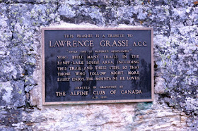
Here, Joan poses for me on the Grassi Steps,
built by Lawrence Grassi.
In truth we were headed down the steps, but I thought up would look best for the photo.

I love this next image, which I took along the Oesa trail with zoom. Hikers on the Yukness Ledges stand in front of Mount Yukness. Note the light coating of snow at the higher altitude. Joan and I were caught in a shower down at Lake O'Hara before reaching our cabin, but not as wet as the day before.
After dinner the weather and lighting were begging us to take another stroll.
Mists lingered above.
Our traveling pigs, Knuckles and Pierre, were waiting for us at the cabin.
Tomorrow, tomorrow. Would we make it to Sleeping Poet's Pool?

Monday, September 14, 2015

CR2015: Lake McArthur and Odaray Highline

July 26th began overcast, but not particularly threatening. Joan and I decided to head for Lake McArthur, using the Big Larches trail for the first part of the approach.
In this photo we have emerged from the woods at left, and will be climbing a staircase-like trail at far right.
In a couple of minutes Joan spotted mountain goats on the flanks of Mount Schäffer (click to enlarge). We also caught up to a couple, Edith and Renee, whom we knew from this and earlier years. After chatting briefly they marched on ahead.
We tore ourselves away from goat-watching and continued, past the All Souls Prospect trail, and past Schäffer Lake. We took the meadow route to the junction with the Odaray Highline trail,
where there's a kiosk to sign in to limit the number of parties heading further on that trail. It almost always fills up early; however, today there was only one party. So far. We continued towards our original goal, McArthur.

Soon there was a decision to be made, because there are two trails to Lake McArthur, the Highline and the Low Level. Joan and I chose to make a loop, entering via the Highline and leaving via the Low Level. On the Highline the trail led through scree and boulders,
and there are a couple of high steps that might look intimidating at first, but even tykes can navigate them with a bit of help.
We followed the Highline,
 to the web of trails at the shores of Lake McArthur.
Both we and the family ahead of us lunched here.
A passing marmot caused the littlest to scream and run for Mom, but otherwise they appeared to be having a good time.

After our cookies were all gone, we wandered down to where the Low Level trail meets the lakeside. This year, the lake's waters were normal or a touch low,
in contrast to our 2012 visit.
On reaching the lip of the McArthur basin, the Low Level trail plunges.
This view is before reaching the low point of the Low Level trail. Hikers must regain some of the lost altitude to complete the loop.
Joan and I returned to the Odaray kiosk.
There were still remaining slots to visit the Odaray Highline today, and we decided to go. Soon we were hearing and seeing pikas and hoary marmots.
We reached the end of the Highline.
Beyond, the Odaray Prospect has been closed for decades in deference to the grizzly bears that favor it.
The way to continue would be the steep path up to Odaray Grandview, but there had been intermittent light sprinkles, and the clouds were thickening. We knew the wind would be fierce at the top. Joan and I had climbed the Grandview last year, so we decided to return the way we had come. Even without extending our hike to the Grandview, the scenery was wonderful.
This picture zooms across the valley to show the exposed switchbacks of the All Souls' Prospect trail.
We returned largely the way we had come, except we took the alternate route down to Schäffer Lake. Descending the Big Larches trail, we enjoyed an even better view of the mountain goats spotted in the morning.

There was a light rain for the last twenty minutes of the hike, but it didn't detract from another rewarding day at Lake O'Hara, and we looked forward to tomorrow. If the weather holds, perhaps we'll tackle Wiwaxy Gap.

Wednesday, September 9, 2015

CR2015: Rainy Day at Lake O'Hara, and a Show

It rained most of July 25th. It started out with a light shower at breakfast, followed by an interval of sunshine, but Joan and I had barely left the lakeshore on the West Opabin trail when the rains came and we made a major stop to don our rain pants and waterproof gloves.

The Opabin Plateau is our first choice for a rainy-day hike. It's not too far or too high, and there are plenty of trails (east side, west side, highline, prospect, and more) to indulge in. In fact, we have a favorite bunch of trees, near Hungabee Lake, to shelter behind for lunch. Today the rain kept intensifying, and the further up the plateau we went, the colder it got. After two hours in the rain my "waterproof" gloves were soaked. We visited Lake Opabin but did not stop long. By the time we approached our lunch tree, my hands were cold, and I suggested going straight back to the cabin to eat lunch instead. Joan agreed. Enough was, well, enough.

We did some reading during the mid-afternoon. When the weather cleared shortly before dinner, we took a walk.

There was much to see. The low angle of the sun pulled the details out of surrounding mountain faces. Note the watercourses tumbling down Mount Hungabee.

A closeup. Of some mountain. I forget which.
Others were enjoying the improved weather.
In July there is a lot of bird activity -- at this altitude and latitude it's spring, not summer. We enjoyed the frequent hermit thrushes, an uncommon sighting where we live.
I admired the look of these new canoes in the water.

After dinner it was time for a long-standing Saturday tradition at Lake O'Hara, the staff show. It opens with a musical number in which most staff members take part. A note on the colors in these pictures: there were colored lights on the second floor shining on the performers, managed by a "lighting director." Some photos show multi-colored shadows.
The opening and closing songs are the same during a season, but the other performances change each week. This time, two guys were playing emcee.
Fancy glasses, bro.
There's a ton of musical talent on display through several acts.
One musician played multiple instruments, including a hand organ.
One act was, what shall I call it? Blind hands? A sheet hides a second person behind the first. The front person can see, but his/her hands are hidden. The person in back can't see, but provides the hands. The person in front will say something such as, "time to put on my lipstick," and hilarity ensues.
It sounds simple and sophomoric, a single joke, but it's presented in one form or another in every show, and it always works. People can't stop laughing. Even me.

Another act was the Marmot Book Club, with four lady marmots. Guy marmots do not do book clubs.

The show ended with a big song, Lake O'Hara lyrics to the tune of Sweet Caroline. Tomorrow, we knew, the weather must be better.

Tuesday, September 8, 2015

CR2015: Lake O'Hara, Part 1

We hied ourselves to the Lake O'Hara parking area, just off the TransCanada, early on July 24th. I needed a few extra minutes to find a decent parking spot.

The lodge bus maneuvered up the 11 km of fire road and pulled up to the lodge.
Joan and I checked in and picked up our trail lunches. The cabins wouldn't be ready until after 1pm, so we set off for Lake Oesa, a popular destination compatible with having a late start and needing to unpack before dinner.

We started clockwise around the Lakeshore Trail. Here's the view looking south from the benches in front of the warden's cabin.

The trail to Oesa splits from the Lakeshore Trail in just under a kilometer. We had gone just a few steps up the Oesa trail, still with a good view of the lakeshore, when we thought we heard familiar voices. Some folks go to Lake O'Hara the same time every year ... Joan and I scanned the Lakeshore Trail ... it was Jim and Gabby, approaching the intersection! We had been at O'Hara simultaneously a couple of times before, starting with meeting Gabby on the steep climb to Wiwaxy Gap. We paused and called out, and they recognized us by the pigs on the outside of our daypacks. They were headed to Oesa too, and we joined forces.

Lake O'Hara opens up even after the first short climb on the way to Oesa.

After the first big altitude gain the Oesa trail climbs more gradually, winding through several boulder fields separated by tongues of conifer woods. Looking back:

The latter part of the trail must cross several rock faces, some by swinging to the far (left going up) side of the valley, and some by neatly constructed rock stairways built by the legendary Lawrence Grassi.

The rock faces, now walked past so easily, are imposing.

Smaller lakes entertain you on the way. This is Victoria Lake, which is also the terminus/origin of a bypass trail connecting to the Yukness Ledges trail, offering a shorter route across Yukness than through Oesa.

After climbing a bit more, and passing one more small lake, we entered the broad expanse in front of Lake Oesa and found a lunch spot. Today was overcast and chilly, especially at 7400 feet with a light breeze.

Here are Gabby, Jim, and Joan, left to right.

We returned the way we had come, but on reaching the Lakeshore Trail Joan and I continued clockwise and Jim and Gabby continued counter-clockwise. Near the end of our loop, I took this picture including the docks at the lodge.

Then it was time to go to our cabin and unpack.